Sand dam

Last updated
Sand dam project in Ethiopia

Sand dams are a simple, low-cost and low-maintenance, replicable rainwater harvesting technology. They provide a clean, local water supply for domestic and farming use and are suited to semi-arid areas of the world.

Contents

Operation

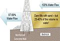
A sand dam is a reinforced concrete wall (or a similarly robust and impermeable weir) built 1–5 metres high across a seasonal sand river.

When it rains the dam captures soil laden water behind it – the sand in the water sinks to the bottom, whilst the silt remains suspended in the water.

Research on Kenyan dams shows that only 1 to 3% of rainwater is retained behind any individual dam, the remainder continues its natural flow towards the ocean. [1] Eventually the dams fill with sand - sometimes after only one rainfall or over 1 – 3 seasons. 25 to 40% of the volume of the sand held is actually water.

A mature sand dam can store millions of litres of water – refilling after each rainfall providing a year round supply of clean water to over 1,000 people.

Application

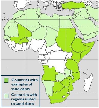
The highest concentration of sand dams with the strongest track record is found in Kenya although examples are found throughout world’s semi-arid regions from Angola to Zimbabwe. Further examples are recorded in Japan, India, Thailand, SW USA and Brazil.

Africa sand dams.jpg

Sand dams can be built in the upper and middle courses of seasonal sandy river valleys (also known as wadis). Typically, sand dams are built in the transition zone between hills and plains where the gradient of the river bed is between 0.2 - 4%, but in extreme cases sand storage dams have been constructed on slopes of 10-16% (Nilsson 1988). Dams must be built on bed rock or highly compacted sub-soil. For the obvious reason of economy on materials and labour, the stream must be reasonably narrow with well defined and stable river banks and the bedrock or impermeable subsoil within a few metres of the stream bed. Rocky banks and gorges are the most apt features. Further advice on the siting, design and construction of sand dams is available from the organisations and in the manuals listed below

Extracting stored water

There are two simple ways:

  1. Scooping a hole in the sand. The water will naturally emerge to the surface. Scope holes used for domestic water should be protected from contamination by livestock (by using acacia fencing or similar)
  2. A slotted pipe buried in the sand that either passes through the dam wall or is connected to a simple hand pump situated on the river bank

Benefits

  1. Low cost and maintenance: Sand dams are the lowest cost form of rainwater harvesting known – 3 to 100 times lower cost than other technologies. A sand dam is built to last over 50 years, has no operational costs and requires little maintenance.
  2. Community owned and managed: Most examples of sand dams are built by members of the communities they serve with support local and international development agencies. Community ownership and management is key to their successful operation.
  3. They save time and enable increased food production and tree planting: During drought periods in semi-arid regions, people might have to walk up to 12 hours a day to fetch water, which is often unsafe to drink. Freed from the chore of walking sometimes the whole day to collect the water, farmers are able to improve food production and generate surplus income.
  4. They provide a clean, secure and local year-round water supply in water scarce environments: The sand effectively acts as a large slow sand filter resulting high quality potable water. As the water is held under the sand, evaporation is minimal, people are protected from water-borne diseases and mosquitoes can’t breed – reducing the threat of malaria.
  5. Wider benefits for health, education and communities: In areas where sand dams have been built, communities have observed a dramatic fall in water related disease, an increase in school attendance and a significant increase in household income and food production.
  6. They transform the local ecology: The water held in the sand behind the dam spreads horizontally creating a permanent increase in the water table, allowing trees to grow naturally and transform the local ecology. The dams create a natural buffer that reduces the threat posed by flooding and drought and builds the resilience of communities to cope with the impacts of climate change in semi-arid regions.

Case Study: A socio-economic effort at Community Development in Kitui, Kenya

On a global scale climate change and effects there of have exerted tremendous pressure on the biophysical, economic, political and social systems that govern the sustenance of a majority of African populations. (Zierrogel et al, 2009)

“Climate Change is expected to intensify existing problems and create new combinations of risks, particularly in Africa where there is widespread poverty and dependence on the natural environment.” (Zierrogel et al. 2009)

Kitui is a region in Eastern Kenya, East Africa, where the sand dam project has been relatively more successful in comparison to other regions that adopted the same or similar systems. The Kitui region has approximately five hundred functional sand dams that help with water storage for subsistence and commercial purposes for example irrigation, domestic use and for feeding and sustaining livestock. (Maurits, 2008)

Effectiveness of Sand Dams in Kitui

With the setup of over 500 dams in the region there is no question to how these sand dams are a major community requirement. The image below shows an overview of the multiple uses of sand dams in the Kitui region. (Lasagne, 2008)

Image: Table showing Sand Dams use in Kitui (Lasagne, 2008)

Image 2.0: Table showing Sand Dams use in Kitui (Lasagne, 2008) Sand Dams.jpg
Image 2.0: Table showing Sand Dams use in Kitui (Lasagne, 2008)

Human welfare:- these dams provide water security during the dry season when numerous rivers and wells dry up due to the harsh conditions of the region. (Lasagne, 2008)

Quality of nature:- The dams provide water to the ecosystem by feeding the water table hence trees and flora are able to thrive in the surrounding areas. (Lasagne, 2008)

Food capacity:- Due to access to water reserves numerous individuals engage in subsistence and semi-commercial farming which creates a source of income and livelihood for the Kitui People. (Lasagne, 2008)

Industrial use:- On a larger scale these dams provide water for industrial capacity as individuals are able to engage on economic activities such as charcoal production, basket making and brick laying which creates a semi-stable source of income for the locals. (Lasagne, 2008)

Hindrances to the sand dam project

There are numerous obstacles to the sand dam projects but the major ones that stand out are irregularity of the rainy seasons, slow funding, lack of communal platforms to run the projects and maintain them. (Lasagne, 2008)

Conclusion

“The average income of farmers using sand dams rose with 9000 KSh. (USD 120), while less than 3% of total runoff is used. It is estimated that in 10 years time, more than 100,000 people have better access to water through low cost measure at an investment of about 35 USD per capita.” (Lasagne, 2008) If these projects had more government, Non-governmental participation and an increased community involvement, Kitui could be a world renown model for the ability of rural communities to combat drought , famine and other effects of climate change.

Sand dam building organizations

Polish Humanitarian Action building dams in Kenya and Madagascar

Related Research Articles

<span class="mw-page-title-main">Geography of Kenya</span> Geographical features of Kenya

The Geography of Kenya is diverse, varying amongst its 47 counties. Kenya has a coastline on the Indian Ocean, which contains swamps of East African mangroves. Inland are broad plains and numerous hills. Kenya borders South Sudan to the northwest, Uganda to the west, Somalia to the east, Tanzania to the south, and Ethiopia to the north and currently facing border disputes with South Sudan over the Ilemi Triangle and the dispute over Jubbaland in Somalia where if the Somalian Government gives it up it could be a new part of Kenya bringing the total land area of Kenya to approximately to 692,939km2.

<span class="mw-page-title-main">Drought</span> Extended period of deficiency in a regions water supply

A drought is a period of drier-than-normal conditions. A drought can last for days, months or years. Drought often has large impacts on the ecosystems and agriculture of affected regions, and causes harm to the local economy. Annual dry seasons in the tropics significantly increase the chances of a drought developing and subsequent wildfires. Periods of heat can significantly worsen drought conditions by hastening evaporation of water vapour, drying out forests and other vegetation and increasing fuel for wildfires.

<span class="mw-page-title-main">Rainwater harvesting</span> Accumulation of rainwater for reuse

Rainwater harvesting (RWH) is the collection and storage of rain, rather than allowing it to run off. Rainwater is collected from a roof-like surface and redirected to a tank, cistern, deep pit, aquifer, or a reservoir with percolation, so that it seeps down and restores the ground water. Dew and fog can also be collected with nets or other tools. Rainwater harvesting differs from stormwater harvesting as the runoff is typically collected from roofs and other surfaces for storage and subsequent reuse. Its uses include watering gardens, livestock, irrigation, domestic use with proper treatment, and domestic heating. The harvested water can also be committed to longer-term storage or groundwater recharge.

<span class="mw-page-title-main">Tana River (Kenya)</span>

The ca. 1000 km long Tana River is the longest river in Kenya, it is also called Sagana River in the Mt Kenya region and gives its name to the Tana River County. Its catchment covers ca. 100,000 km² and can be divided into the headwaters and the lower Tana consisting of the section downstream of Kora where the river flows for ca. 700 km through semi-arid plains. Its tributaries include some major rivers in the Central Region like Thika, Ragati River, Nyamindi, Thiba ,Mathioya, Chania in short all Rivers flowing from Mt Kenya and Aberdare Ranges all end up in River Tana. The river rises from Mt Kenya in Nyeri. Initially it runs east before turning south around the massif of Mount Kenya and meanders all the way up to Indian Ocean. A series of hydroelectric dams has been constructed along the river. These include the Masinga Dam, the Kamburu Dam, the Gitaru Dam, the Kindaruma Dam and the Kiambere Dam. en The Masinga Reservoir and the Kiambere Reservoir, created by the Masinga and Kiambere dams respectively, serve a dual purpose: hydro-electric power (HEP) generation and agricultural irrigation. The other three are used exclusively for HEP generation. A 2003 study reported that two-thirds of Kenya's electrical needs were supplied by the series of dams along the Tana River. Many people believe this river has groundwater underneath it, but it doesn't. The electricity is then supplied to the national grid system and distributed countrywide through a series of substations, transformers and cables.

<span class="mw-page-title-main">Reservoir</span> Storage space for water

A reservoir is an enlarged lake behind a dam. Such a dam may be either artificial, usually built to store fresh water, or it may be a natural formation.

<span class="mw-page-title-main">Environmental issues in Kenya</span>

Environmental issues in Kenya include deforestation, soil erosion, desertification, water shortage and degraded water quality, flooding, poaching, and domestic and industrial pollution.

<span class="mw-page-title-main">Groundwater recharge</span> Groundwater that recharges an aquifer

Groundwater recharge or deep drainage or deep percolation is a hydrologic process, where water moves downward from surface water to groundwater. Recharge is the primary method through which water enters an aquifer. This process usually occurs in the vadose zone below plant roots and is often expressed as a flux to the water table surface. Groundwater recharge also encompasses water moving away from the water table farther into the saturated zone. Recharge occurs both naturally and through anthropogenic processes, where rainwater and or reclaimed water is routed to the subsurface.

<span class="mw-page-title-main">Kwale County</span> County in Kenya

Kwale County is a county in the former Coast Province of Kenya. Its capital is Kwale, although Ukunda is the largest town.

Water resources management is a significant challenge for Mexico. The country has in place a system of water resources management that includes both central (federal) and decentralized institutions. Furthermore, water management is imposing a heavy cost to the economy.

<span class="mw-page-title-main">Water security</span> A goal of water management to harness water-related opportunities and manage risks

The aim of water security is to make the most of water's benefits for humans and ecosystems. The second aim is to limit the risks of destructive impacts of water to an acceptable level. These risks include for example too much water (flood), too little water or poor quality (polluted) water. People who live with a high level of water security always have access to "an acceptable quantity and quality of water for health, livelihoods and production". For example, access to water, sanitation and hygiene services is one part of water security. Some organizations use the term water security more narrowly for water supply aspects only.

<span class="mw-page-title-main">Taanka</span> Rainwater harvesting technique

A taanka or paar, is a traditional rainwater harvesting technique, common to the Thar desert region of Rajasthan, India. It is meant to provide drinking water and water security for a family or a small group of families. A taanka is composed of a covered, underground, impermeable cistern on shallow ground for the collection of rainwater. The cistern is generally constructed out of stone or brick masonry, or concrete, with lime mortar or cement plaster. Rainwater or surface run-off from rooftops, courtyards, or artificially prepared catchments flow into the tank through filtered inlets in the wall of the pit.

<span class="mw-page-title-main">Desert greening</span> Process of man-made reclamation of deserts

Desert greening is the process of afforestation or revegetation of deserts for ecological restoration (biodiversity), sustainable farming and forestry, but also for reclamation of natural water systems and other ecological systems that support life. The term "desert greening" is intended to apply to both cold and hot arid and semi-arid deserts. It does not apply to ice capped or permafrost regions. It pertains to roughly 32 million square kilometres of land. Deserts span all seven continents of the Earth and make up nearly a fifth of the Earth's landmass, areas that recently have been increasing in size. As some of the deserts expand and global temperatures increase, the different methods of desert greening may provide a potential solution. Planting suitable flora in deserts has a range of environmental benefits from carbon sequestration to providing habitat for native desert fauna to generating employment opportunities to creation of habitable areas for local communities. The prevention of land desertification is one of 17 sustainable development objectives outlined by the United Nations, desert greening is a process that aims to not only combat desertification but to foster an environment where plants can create a sustainable environment for all forms of life while preserving its integrity.

<span class="mw-page-title-main">Water supply and sanitation in Kenya</span>

Water supply and sanitation in Kenya is characterised by low levels of access to water and sanitation, in particular in urban slums and in rural areas, as well as poor service quality in the form of intermittent water supply. Seasonal and regional water scarcity in Kenya exacerbates the difficulty to improve water supply.

<span class="mw-page-title-main">Water scarcity in Africa</span> Overview of water scarcity in Africa

Water scarcity in Africa is predicted to reach dangerously high levels by 2025 when it is estimated that about two-thirds of the world's population may suffer from fresh water shortage. The main causes of water scarcity in Africa are physical and economic scarcity, rapid population growth, and climate change. Water scarcity is the lack of fresh water resources to meet the standard water demand. Although Sub-Saharan Africa has a plentiful supply of rainwater, it is seasonal and unevenly distributed, leading to frequent floods and droughts. Additionally, prevalent economic development and poverty issues, compounded with rapid population growth and rural-urban migration have rendered Sub-Saharan Africa as the world's poorest and least developed region.

<span class="mw-page-title-main">Water issues in developing countries</span> Water issues and problems in developing countries are diverse and serious

Water issues in developing countries include scarcity of drinking water, poor infrastructure for water and sanitation access, water pollution, and low levels of water security. Over one billion people in developing countries have inadequate access to clean water. The main barriers to addressing water problems in developing nations include poverty, costs of infrastructure, and poor governance. The effects of climate change on the water cycle can make these problems worse.

Mutomo District was a former district in the Eastern Province of Kenya. Its population is 180,000. The administrative center of the district is Mutomo. In 2010, it was merged into Kitui County.

South Eastern Kenya University "SEKU" is a public university with its main campus located in Kwa Vonza, Kitui County, Kenya.

<span class="mw-page-title-main">Climate change in Kenya</span> Emissions, impacts and responses of Kenya related to climate change

Climate change is posing an increasing threat to global socio-economic development and environmental sustainability. Developing countries with low adaptive capacity and high vulnerability to the phenomenon are disproportionately affected. Climate change in Kenya is increasingly impacting the lives of Kenya's citizens and the environment. Climate Change has led to more frequent extreme weather events like droughts which last longer than usual, irregular and unpredictable rainfall, flooding and increasing temperatures.

<span class="mw-page-title-main">2008–2009 Kenya drought</span>

Between 2008 and early 2010, Kenya, one of the countries of Eastern Africa, was affected by a severe drought, which put ten million people at risk of hunger and caused a large number of deaths to livestock in Kenyan Arid and Semi-Arid Lands (ASALs), constituting around 88% of the country.

Rainwater management is a series of countermeasures to reduce runoff volume and improve water quality by replicating the natural hydrology and water balance of a site, with consideration of rainwater harvesting, urban flood management and rainwater runoff pollution control.

References

  1. Hut et al 2008

Bibliography