Soil salinity is the salt content in the soil; the process of increasing the salt content is known as salinization. Salts occur naturally within soils and water. Salination can be caused by natural processes such as mineral weathering or by the gradual withdrawal of an ocean. It can also come about through artificial processes such as irrigation and road salt.
In geotechnical engineering, watertable control is the practice of controlling the height of the water table by drainage. Its main applications are in agricultural land and in cities to manage the extensive underground infrastructure that includes the foundations of large buildings, underground transit systems, and extensive utilities.
Groundwater models are computer models of groundwater flow systems, and are used by hydrologists and hydrogeologists. Groundwater models are used to simulate and predict aquifer conditions.

Soil salinity control relates to controlling the problem of soil salinity, with the aim of preventing soil degradation by salination and reclamation of already salty (saline) soils. Soil reclamation is also called soil improvement, rehabilitation, remediation, recuperation or amelioration.
Well drainage means drainage of agricultural lands by wells. Agricultural land is drained by pumped wells to improve the soils by controlling water table levels and soil salinity.
Alkali, or Alkaline, soils are clay soils with high pH, a poor soil structure and a low infiltration capacity. Often they have a hard calcareous layer at 0.5 to 1 metre depth. Alkali soils owe their unfavorable physico-chemical properties mainly to the dominating presence of sodium carbonate, which causes the soil to swell and difficult to clarify/settle. They derive their name from the alkali metal group of elements, to which sodium belongs, and which can induce basicity. Sometimes these soils are also referred to as alkaline sodic soils.
Alkaline soils are basic, but not all basic soils are alkaline.
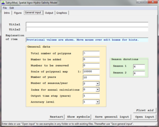
SahysMod is a computer program for the prediction of the salinity of soil moisture, groundwater and drainage water, the depth of the watertable, and the drain discharge in irrigated agricultural lands, using different hydrogeologic and aquifer conditions, varying water management options, including the use of ground water for irrigation, and several crop rotation schedules, whereby the spatial variations are accounted for through a network of polygons.
Drainage research is the study of agricultural drainage systems and their effects to arrive at optimal system design.
A runoff model is a mathematical model describing the rainfall–runoff relations of a rainfall catchment area, drainage basin or watershed. More precisely, it produces a surface runoff hydrograph in response to a rainfall event, represented by and input as a hyetograph. In other words, the model calculates the conversion of rainfall into runoff.
A well known runoff model is the linear reservoir, but in practice it has limited applicability.
The runoff model with a non-linear reservoir is more universally applicable, but still it holds only for catchments whose surface area is limited by the condition that the rainfall can be considered more or less uniformly distributed over the area. The maximum size of the watershed then depends on the rainfall characteristics of the region. When the study area is too large, it can be divided into sub-catchments and the various runoff hydrographs may be combined using flood routing techniques.

SaltMod is computer program for the prediction of the salinity of soil moisture, groundwater and drainage water, the depth of the watertable, and the drain discharge (hydrology) in irrigated agricultural lands, using different (geo)hydrologic conditions, varying water management options, including the use of ground water for irrigation, and several cropping rotation schedules. The water management options include irrigation, drainage, and the use of subsurface drainage water from pipe drains, ditches or wells for irrigation.

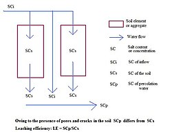
In agriculture, leaching is the loss of water-soluble plant nutrients from the soil, due to rain and irrigation. Soil structure, crop planting, type and application rates of fertilizers, and other factors are taken into account to avoid excessive nutrient loss. Leaching may also refer to the practice of applying a small amount of excess irrigation where the water has a high salt content to avoid salts from building up in the soil. Where this is practiced, drainage must also usually be employed, to carry away the excess water.

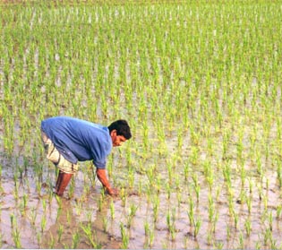
Surface irrigation is where water is applied and distributed over the soil surface by gravity. It is by far the most common form of irrigation throughout the world and has been practiced in many areas virtually unchanged for thousands of years.
An agricultural drainage system is a system by which water is drained on or in the soil to enhance agricultural production of crops. It may involve any combination of stormwater control, erosion control, and watertable control.

Agricultural hydrology is the study of water balance components intervening in agricultural water management, especially in irrigation and drainage.

The environmental effects of irrigation relate to the changes in quantity and quality of soil and water as a result of irrigation and the subsequent effects on natural and social conditions in river basins and downstream of an irrigation scheme. The effects stem from the altered hydrological conditions caused by the installation and operation of the irrigation scheme.
This page shows statistical data on irrigation of agricultural lands worldwide.
Irrigation is the artificial abstraction of water from a source followed by the distribution of it at scheme level aiming at application at field level to enhance crop production when rainfall is scarce.
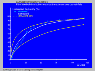
In statistics and data analysis the application software CumFreq is a tool for cumulative frequency analysis of a single variable and for probability distribution fitting.

Salt tolerance of crops is the maximum salt level a crop tolerates without losing its productivity while it is affected negatively at higher levels. The salt level is often taken as the soil salinity or the salinity of the irrigation water.
Crop tolerance to seawater is the ability of an agricultural crop to withstand the high salinity induced by irrigation with seawater, or a mixture of fresh water and seawater. There are crops that can grow on seawater and demonstration farms have shown the feasibility. The government of the Netherlands reports a breakthrough in food security as specific varieties of potatoes, carrots, red onions, white cabbage and broccoli appear to thrive if they are irrigated with salt water.
Water use in alluvial fans refers to irrigation systems using the water resources in alluvial fans, mainly river floods and groundwater recharged by infiltration of rain or river water, to enhance the production of agricultural crops.