Drainage research

Last updated

Drainage research is the study of agricultural drainage systems and their effects to arrive at optimal system design.

Contents

Overview

Figure 1. DrDiagram.JPG
Figure 1.

Agricultural land drainage has agricultural, environmental, hydrological, engineering, economical, social and socio-political aspects (Figure 1). All these aspects can be subject of drainage research.

The aim (objective, target) of agricultural land drainage is the optimized agricultural production related to:

Systems analysis

Figure 2. DrDesign.JPG
Figure 2.

The role of targets, criterion, environmental, and hydrological factors is illustrated in Figure 2. In this figure criterion factors are factors influenced by drainage on the one hand and the agricultural performance on the other.

An example of a criterion factor is the depth of the water table:

  1. A drainage system influences this depth; the relation between drainage system design and depth of water table is mainly physical and can be described by drainage equations, in which the drainage requirements are to be found from a water balance. [1]
  2. The depth of the water table as a criterion factor needs to be translated into a criterion index to be given a numerical value that represents the behavior of the water table on the one hand and that can be related to the target (e.g. crop production) on the other hand.
  3. The relation between criterion index and target can often be optimized, the maximum value providing the ultimate aim while the corresponding value of the criterion index can be used as an agricultural drainage criterion in the design procedure.

Crop response processes

Figure 3. CrResponse.JPG
Figure 3.

The underlying processes in the optimization (as in the insert of Figure 2) are manifold. The processes can be grouped into mutually dependent soil physical, soil chemical/biological, and hydrological processes (Figure 3):

Examples of processes can be found in. [3]

Field data

Crop yield (Y) and depth of water table (X in dm) R-3VAR1.JPG
Crop yield (Y) and depth of water table (X in dm)

In drainage research the collection and analysis of field data is important. [5]

In dealing with field data one must expect considerable random variation owing to the large number of natural processes involved and the large variability of plant and soil properties and hydrological conditions.

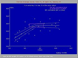
An example of a relation between crop yield and depth of water table subject to random natural variation is shown in the attached graph. The graph was made with the SegReg program, see segmented regression.

When analysing field data with random variation a proper application of statistical principles like in regression and frequency analysis is necessary.

Soil salinity control

In irrigated lands, subsurface drainage may be required to leach the salts brought into the soil with the irrigation water to prevent soil salination.

Agro-hydro-salinity and leaching models like SaltMod [6] may be helpful to determine the drainage requirement.

Related Research Articles

<span class="mw-page-title-main">Soil salinity</span> Salt content in the soil

Soil salinity is the salt content in the soil; the process of increasing the salt content is known as salinization. Salts occur naturally within soils and water. Salination can be caused by natural processes such as mineral weathering or by the gradual withdrawal of an ocean. It can also come about through artificial processes such as irrigation and road salt.

In geotechnical engineering, watertable control is the practice of controlling the height of the water table by drainage. Its main applications are in agricultural land and in cities to manage the extensive underground infrastructure that includes the foundations of large buildings, underground transit systems, and extensive utilities.

Groundwater models are computer models of groundwater flow systems, and are used by hydrologists and hydrogeologists. Groundwater models are used to simulate and predict aquifer conditions.

<span class="mw-page-title-main">Soil salinity control</span> Controlling the problem of soil salinity

Soil salinity control refers to controlling the process and progress of soil salinity to prevent soil degradation by salination and reclamation of already salty (saline) soils. Soil reclamation is also known as soil improvement, rehabilitation, remediation, recuperation, or amelioration.

Segmented regression, also known as piecewise regression or broken-stick regression, is a method in regression analysis in which the independent variable is partitioned into intervals and a separate line segment is fit to each interval. Segmented regression analysis can also be performed on multivariate data by partitioning the various independent variables. Segmented regression is useful when the independent variables, clustered into different groups, exhibit different relationships between the variables in these regions. The boundaries between the segments are breakpoints.

Well drainage means drainage of agricultural lands by wells. Agricultural land is drained by pumped wells to improve the soils by controlling water table levels and soil salinity.

<span class="mw-page-title-main">SahysMod</span>

SahysMod is a computer program for the prediction of the salinity of soil moisture, groundwater and drainage water, the depth of the watertable, and the drain discharge in irrigated agricultural lands, using different hydrogeologic and aquifer conditions, varying water management options, including the use of ground water for irrigation, and several crop rotation schedules, whereby the spatial variations are accounted for through a network of polygons.

<span class="mw-page-title-main">Runoff model (reservoir)</span> Type of water motion

A runoff models or rainfall-runoff model describes how rainfall is converted into runoff in a drainage basin. More precisely, it produces a surface runoff hydrograph in response to a rainfall event, represented by and input as a hyetograph. Rainfall-runoff models need to be calibrated before they can be used.

<span class="mw-page-title-main">SaltMod</span> Salinity modelling software

SaltMod is computer program for the prediction of the salinity of soil moisture, groundwater and drainage water, the depth of the watertable, and the drain discharge (hydrology) in irrigated agricultural lands, using different (geo)hydrologic conditions, varying water management options, including the use of ground water for irrigation, and several cropping rotation schedules. The water management options include irrigation, drainage, and the use of subsurface drainage water from pipe drains, ditches or wells for irrigation.

<span class="mw-page-title-main">Surface irrigation</span> Form of irrigation

Surface irrigation is where water is applied and distributed over the soil surface by gravity. It is by far the most common form of irrigation throughout the world and has been practiced in many areas virtually unchanged for thousands of years.

An agricultural drainage system is a system by which water is drained on or in the soil to enhance agricultural production of crops. It may involve any combination of stormwater control, erosion control, and watertable control.

<span class="mw-page-title-main">Agricultural hydrology</span>

Agricultural hydrology is the study of water balance components intervening in agricultural water management, especially in irrigation and drainage.

<span class="mw-page-title-main">Environmental effects of irrigation</span> Land & irrigation

The environmental effects of irrigation relate to the changes in quantity and quality of soil and water as a result of irrigation and the subsequent effects on natural and social conditions in river basins and downstream of an irrigation scheme. The effects stem from the altered hydrological conditions caused by the installation and operation of the irrigation scheme.

A leaching model is a hydrological model by which the leaching with irrigation water of dissolved substances, notably salt, in the soil is described depending on the hydrological regime and the soil's properties.

This page shows statistical data on irrigation of agricultural lands worldwide.
Irrigation is the artificial abstraction of water from a source followed by the distribution of it at scheme level aiming at application at field level to enhance crop production when rainfall is scarce.

<span class="mw-page-title-main">Drainage equation</span> Equation used in drainage design

A drainage equation is an equation describing the relation between depth and spacing of parallel subsurface drains, depth of the watertable, depth and hydraulic conductivity of the soils. It is used in drainage design.

Irrigation in Iran covers 89,930 km2 making it the fifth ranked country in terms of irrigated area.

<span class="mw-page-title-main">CumFreq</span> Software tool for data analysis and statistics

In statistics and data analysis the application software CumFreq is a tool for cumulative frequency analysis of a single variable and for probability distribution fitting.

<span class="mw-page-title-main">Salt tolerance of crops</span>

Salt tolerance of crops is the maximum salt level a crop tolerates without losing its productivity while it is affected negatively at higher levels. The salt level is often taken as the soil salinity or the salinity of the irrigation water.

Water use in alluvial fans refers to irrigation systems using the water resources in alluvial fans, mainly river floods and groundwater recharged by infiltration of rain or river water, to enhance the production of agricultural crops.

References

  1. Drainage for Agriculture: Hydrology and Water Balances. Lecture notes, International Course on Land Drainage (ICLD), International Institute for Land Reclamation and Improvement (ILRI), Wageningen, The Netherlands. Download at :
  2. Ahiablame, L.M.; Chaubey, I.; Smith, D.R.; Engel, B.A. (2011). "Effect of tile effluent on nutrient concentration and retention efficiency in agricultural drainage ditches". Agricultural Water Management. 98 (8): 1271–1279. Bibcode:2011AgWM...98.1271A. doi:10.1016/j.agwat.2011.03.002. ISSN   0378-3774.
  3. Agricultural Drainage Criteria. Chapter 17 in: H.P.Ritzema (ed., 1994), Drainage Principles and Applications, Publication 16, p.635-690. International Institute for Land Reclamation and Improvement (ILRI), Wageningen, The Netherlands. ISBN   90-70754-33-9. Download at :
  4. Data provided by various authors on banana, cotton, sugarcane and wheat response to shallow water tables
  5. Drainage Research in Farmers' Fields: Analysis of Data. Part of project “Liquid Gold” of the International Institute for Land Reclamation and Improvement (ILRI), Wageningen, The Netherlands. Download at :
  6. SaltMod: A tool for interweaving of irrigation and drainage for salinity control. In: W.B.Snellen (ed., 1997), Towards integration of irrigation, and drainage management. Special report, p. 41-43, International Institute for Land Reclamation and Improvement (ILRI), Wageningen, The Netherlands. Download at : "Archived copy" (PDF). Archived from the original (PDF) on 2009-02-19. Retrieved 2009-05-17.{{cite web}}: CS1 maint: archived copy as title (link)