Virugambakkam

Last updated

Virugambakkam
Neighbourhood
Chennai area locator map.svg
Red pog.svg
Virugambakkam
Virugambakkam(Chennai)
India Tamil Nadu location map.svg
Red pog.svg
Virugambakkam
Virugambakkam (Tamil Nadu)
India location map.svg
Red pog.svg
Virugambakkam
Virugambakkam (India)
Coordinates: 13°02′58″N80°11′06″E / 13.049557°N 80.184928°E / 13.049557; 80.184928
CountryIndia
State Tamil Nadu
District Chennai
MetroChennai
Elevation
17 m (56 ft)
Languages
  Official Tamil
Time zone UTC+5:30 (IST)
PIN
600 092
Vehicle registration TN 10 (RTO, Chennai South West)
Lok Sabha constituencyChennai South
Vidhan Sabha constituencyVirugambakkam

Virugambakkam is a residential neighbourhood of Chennai, Tamil Nadu, India. It is an important residential area of and is famous for its schools, market, residential colonies and residences of film artists. Virugambakkam had some of Chennai's oldest film studios.

Contents

Virugambakkam is one of the important localities of Chennai and owes its growth to the expansion of the city in the post-independence period. Prior to the establishment of residential colonies, Virugambakkam was a village covered by paddy fields, mango orchards and casuarina trees. Virugambakkam was first included within the Chennai city limits in 1977 along with other villages like Saligramam.

Virugambakkam is well-connected with the heart of Chennai city through roads. Buses running through Arcot Road link Virugambakkam with the more inner suburbs of Chennai city.

Location

Virugambakkam is situated at a distance of 14.6 kilometres from Fort St George and 12.5 kilometres from Poonamallee. It is bound by Saligramam in the east, Koyambedu to the north and Alwarthirunagar to the west and south-west and K.K. Nagar and Ramavaram, Tamil Nadu to the south-east. Its frontier with Alwarthirunagar forms the western limits of the Corporation of Chennai.

History

The growth of Virugambakkam accompanied the expansion of Madras city during the years preceding independence. Virugambakkam was one of the many localities which cropped up during the Second World War. At that time, it was a part of the Kodambakkam-Saligramam-Puliyur residential district of Greater Madras. [1] [2] During the 1940s, Arcot Road was constructed connecting Nungambakkam with the Mount-Poonamallee Road. In 1948, the first movie studios made their appearance when Avichi Meiyappa Chettiar shifted his base from Karaikudi. [3] The locality has since become a haven for movie producers and cine artists. [4] [5]

Virugambakkam was one of the important places connected with the Anti-Hindi agitations of 1965. Aranganathan, a 32-year-old employee with the Indian Postal Service immolated himself in protest against the imposition of Hindi. [6] The Dravida Munnetra Kazhagam vigorously campaigned in the Virugambakkam region during the 1967 elections. [7] Dravida Munnetra Kazhagam has done a first state level meeting it has been organised by V.P Akilan. the meeting has been held in front of Arignar Anna, Karunanithi, M.G Ramachandran and some leaders in Dravida Munnetra Kazhagam.[ citation needed ]

Until the 1970s, Virugambakkam was little more than an insignificant village. It formed a part of Saidapet taluk of Chengleput district. Apart from a few movie studios, there were only a few sparsely populated settlements. The interior area which makes up the middle-class residential colonies were covered by paddy fields. The town had a population of 8,013 in 1971. During those times, the outlying suburbs of the city alongside Arcot Road had a reputation for insecurity and as the haunt of sex.[ clarification needed ] [8] Until the early 1970s, the suburb of Kodambakkam formed the western frontier of Madras city. Virugambakkam was included in Madras city in 1973 along with Saligrammam. Since then, growth has accelerated, peaking in the 1980s and 1990s. [8] The good quality of ground water available in the Arcot Road suburbs was an important reason for the region's growth. [8]

Geography

The soil is fertile and productive as is evident from the fact that paddy fields once covered the area. However, paddy fields have completely disappeared. Natural gas was discovered near Virugambakkam in 1966. [9] To date, Virugambakkam is the only known source of natural gas in Chennai city apart from Avadi. [9]

Once Virugambakkam had a big lake which was maintained by Madras Water Supplies and Sewage Board (now called CMWSSB) and drew water for drinking with several pump houses around the lake until 1976, and several small ponds. After that the lake was encroached by antisocial elements with help of all party politicians and converted it into a habitat. The road around that lake turned habitat is called as Erikarai Street. The ponds have also been encroached and turned into habitat.[ citation needed ]

The Virugambakkam Canal separates Virugambakkam from suburbs such as Koyambedu, which lie towards the interior. [10] [11] The canal runs for about 6 kilometres through the suburbs of Choolaimedu, Arumbakkam and Vadapalani before entering Virugambakkam. [10] [12] This canal originally served the purpose of irrigating farm lands. [10] However, with the transformation of farmlands into residential localities, the canal has been converted into a drain. [10] During the monsoons, the canal frequently overflows creating havoc for the residents of the nearby areas. [12] In 2003, desilting work was carried out to deal with the situation. [12]

Localities

Virugambakkam extends for about 2 kilometres from Avichi Higher Sec. School in Arcot Road to Valasarawakkam. Virugambakkam extends alongside Arcot Road adjacent to Saligrammam in the east, Valasaravakkam in the west, Koyambedu in the north and KK Nagar in the south. State Bank Colony and Baskar Colony are some of the important residential areas in the neighbourhood. Kaaliamman Koil Street which connects Virugambakkam and Koyambedu, Arcot Road are the main arterial roads.

Important landmarks

Balalok Matriculation Higher Secondary School in Virugambakkam Balalok school.jpg
Balalok Matriculation Higher Secondary School in Virugambakkam

Virugambakkam is known for its movie studios and schools. It is also the home to a large number of film actors, music composers and other artists. The Virugambakkam market which lies to the west is a source for fresh vegetables. Some important temples are Vembuliamman Koil, Kaliamman Koil and Raghavendra temple, Sankarashramam-Sri Raja Rajeswari Temple, Hari Hara Temple, Siva Vishnu Temple. There is also a mosque and numerous churches. Virugambakkam also has a number of hospitals which along with the schools and departmental stores cater to the needs of the residential colonies. Virugambakkam RTO Office located at Chinmayanagar on Kaliamman Koil Street. There are also more number of Nationalised & Private Banks. [13] [14]

Shopping malls

Chandra Metro Mall is a shopping mall located in Virugambakkam. The mall has a built up area of 143,000 square feet (13,300 m2) and was opened on 9 April 2011. [15] [16] The mall has a five screen multiplex with a capacity of 1,300 seats called INOX-National operated by INOX Leisure. [17] It has Food Bazaar, E-Zone, Pantaloons as its major anchors. The food court is spread over an area of 10,000 sq. ft. The mall was built after demolishing the National Theatre. The mall's ground floor to floor below the theatre, D-mart is situated. [18]

Educational institutions

Schools

Colleges

Transport and communication

Virugambakkam is well-connected with the heart of Chennai city as it lies on the Arcot Road, which is considered to be one of Chennai's arterial roads. [19] Virugambakkam lies on the Poonamallee-Vadapalani-Broadway bus route. [20] [21] The nearest bus terminuses are Saligrammam, Chennai Moffusil Bus Terminus (CMBT) and Vadapalani. The nearest suburban railway station is at Kodambakkam, 4 kilometres from Virugambakkam. The nearest metro station is at Vadapalani.

Notes

  1. The Indian Geographical Journal. The Indian geographical Society. 1940. p. 20.
  2. The Indian Geographical Journal. The Indian geographical Society. 1940. p. 23.
  3. "A.V. Meiyappa Chettiar Birth entenary".
  4. Muthiah, Pg 397
  5. Muthiah, Pg 398
  6. Asian Recorder. Recorder Press. 1965. p. 6292.
  7. K. S. Ramanujam (1967). The big change. Higginbotham's. p. 157.
  8. 1 2 3 Prince Frederick (7 August 2002). "Arcot Road: There's glamour amidst chaos". The Hindu . Archived from the original on 2 June 2004.
  9. 1 2 Geo Abstracts. University of East Anglia. 1966. p. 494.
  10. 1 2 3 4 "Vigilant residents to monitor Virugambakkam canal works". The Hindu . 2 March 2009. Archived from the original on 7 March 2009.
  11. "Canal cries for attention". The Hindu. 12 June 2003. Archived from the original on 15 November 2004.{{cite news}}: CS1 maint: unfit URL (link)
  12. 1 2 3 "PWD takes up desilting of Virugambakkam canal". The Hindu . 28 June 2003. Archived from the original on 25 March 2005.
  13. V. Subburaj (2006). Tourist Guide to Chennai. Sura Books. p. 14. ISBN   978-81-7478-040-9.
  14. Rajendra Ojha (2006). Screen world. Screen World Publications.
  15. Narayanan, Vivek (9 April 2011). "Suburbs sizzle with malls". The Times of India . Archived from the original on 3 January 2013. Retrieved 27 June 2012.
  16. "Chandra Metromall". Chandra Builders Enterprises Ltd. Archived from the original on 6 July 2012. Retrieved 27 June 2012.
  17. Venkatramam, Deepa (3 April 2011). "More malls to Chennai's skyline". The Hindu. Retrieved 27 June 2012.
  18. "Food Bazaar, E-Zone open at Chandra Mall". Arcot Road Times. Retrieved 27 June 2012.
  19. "New look for Arcot Road". Indian Express . 24 June 1997.
  20. V. Subburaj (2006). Tourist Guide to Chennai. Sura Books. pp. 85–95. ISBN   978-81-7478-040-9.
  21. "List of Routes". Metropolitan Transport Corporation.

Related Research Articles

<span class="mw-page-title-main">Koyambedu</span> Neighborhood of Chennai, India

Koyambedu is a neighbourhood in Chennai, India. Situated in the western part of Chennai city, the Koyambedu area has become a major hub of activity in Chennai City after the inauguration of the Koyambedu market in 1996 and the Chennai Mofussil Bus Terminus (CMBT) in 2002. The area is active round the clock owing to the movement of people and goods through the day, with uninterrupted transport facilities such as long-route buses, autos, share autos, vegetable goods carriers and so forth.

<span class="mw-page-title-main">Avadi</span> Municipal Corporation governing Avadi in Chennai Metropolitan Area

Avadi is a suburb located west of Chennai within Chennai Metropolitan Area in the Thiruvallur district of Tamil Nadu, India. Situated at about 22 kilometres (14 mi) from Chennai Central Railway Station, it is one of the four municipal corporations in Chennai Metropolitan Area and is governed by the Avadi Municipal Corporation. It is surrounded by major defence establishments and is home to various universities and engineering colleges. The neighborhood is served by Avadi Railway Station of the Chennai Suburban Railway. As of 2011, Avadi had a population of 345,996, which is 10th most populous place in Tamil Nadu. It is home to the Heavy Vehicles Factory (HVF), Ordnance Factory Board (ODF) which houses Engine Factory and Combat Vehicles Research and Development Establishment (CVRDE). The lake in Avadi was known as Paaleripattu, which is now found only in very old land documents.

<span class="mw-page-title-main">T. Nagar</span> Neighborhood of Chennai, India

Thyagaraya Nagar, commonly known as T. Nagar, and historically known as East Mambalam, is a very affluent commercial and residential neighbourhood in Chennai, Tamil Nadu, India. It is surrounded by Nungambakkam in the North, Teynampet in the East, Nandanam in the South-East, C.I.T. Nagar in the South and West Mambalam and Kodambakkam in the West. The stretch between Duraiswamy Road and T. Nagar Bus Stand has some of the costliest real estates in Chennai. It was constructed between 1923 and 1925 by the Madras Presidency government of the Raja of Panagal as a part of town planning activities initiated according to the Madras Town Planning Act of 1920. The town was named after P. Thyagaraya Chetty. The streets, parks and localities in the new neighbourhood were named after important officials in the provincial government.

<span class="mw-page-title-main">Tiruvallur</span> Town in Tamil Nadu, India

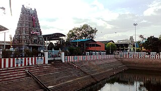
Tiruvallur is a Grade I municipality in the Indian state of Tamil Nadu. It is located on the banks of Coovum river about 46 km (29 mi) from downtown Chennai (Madras) and just 5 km from megacity border, in the western part of the Chennai Metropolitan Area (CMA). It is a satellite town of Chennai and is the administrative headquarters of Tiruvallur district. The city is known for the Veera Raghavar temple, one of the 108 sacred shrines of Vaishnavites. The tank festival is held at a pond near this temple. A Shiva temple near this shrine which is popular among the locals. There is also a 40-foot (12 m) tall Viswaroopa Panchamukha Hanuman temple, where the murti is made of a single green granite stone.

Perambur is a neighbourhood located in the northern region of Chennai, Tamil Nadu, India.

<span class="mw-page-title-main">Poonamallee</span> Suburb of Chennai, India

Poonamallee is town and suburb of Chennai, India under the Chennai Metropolitan Area. It was historically called Pushpagirimangalam, later renamed in Tamil as Poovirundhavalli, and now colloquially called as Poondhamalli. It is the headquarters of the Poonamallee taluk of the Tiruvallur district in the Indian state of Tamil Nadu. The nearest Railway station is at Avadi. It acts as the gateway to the city from its western side. It is a town with rich cultural heritage and also a fast-growing areas in the city. As of 2011, the town had a population of 57,224. There are plans to merge the areas under Poonamallee Municipality with Avadi Municipal Corporation.

<span class="mw-page-title-main">Vadapalani</span> Neighborhood of Chennai, India

Vadapalani is a neighbourhood in the city of Chennai in Tamil Nadu, India. It is known for its film studios and the Vadapalani Andavar Temple, which is an important pilgrimage centre. Situated in the western part of Chennai, Vadapalani is an important bus terminus on Arcot Road. Vadapalani is one of the busiest and densely populated areas in Chennai.

Arumbakkam is a residential locality in Chennai.

West Mambalam is a residential and commercial area in Chennai, India. It is known for its shops, bazaars and Hindu temples. It is bounded by Kodambakkam to the north and Saidapet to the south. T. Nagar and Nandanam stretch all along its eastern frontiers while Ashok Nagar lies to its west. The Ayodhya Mandapam is an important landmark.

Choolaimedu is a large residential and commercial locality in Chennai, Tamil Nadu, India. It borders Kodambakkam, Vadapalani, M.M.D.A. Colony, Aminjikarai, Mahalingapuram and Nungambakkam. Previously a part of Puliyur village, Kodambakkam, Choolaimedu has now become a hub for commercial interests and connects two of the busiest routes in Chennai, namely Arcot Road and Nelson Manickam Road.

Ashok Nagar is a residential locality situated at the southern part of Chennai, Tamil Nadu, India. It was established in 1964. At the heart of this colony, stands the Ashok Pillar. This four lion head stump, resembles the one erected by king Ashoka during the 3rd century BCE at Sanchi.

Purasawalkam also known as Purasaiwakkam or Purasai / Purasawakkam, is a residential shopping area in the district of Chennai in the state of Tamil Nadu, India. It is close to the Chennai Central and Chennai Egmore railway stations.

Alapakkam is a neighbourhood in western part of Central Chennai. It belongs to Central Chennai Revenue Division of Chennai district. It is surrounded by Porur, Valasaravakkam and Maduravoyal. It is part of Chennai corporation under zone 11. Entry in to Alapakkam is through two main roads, that is, Arcot Road and Poonamallee High Road. Alapakkam belongs to Sriperumbudur Lok Sabha constituency and Maduravoyal assembly constituency.

Arcot Road(SH-113) is one of the main arterial roads of the city of Chennai in Tamil Nadu, India. It runs for 12 kilometres and connects Nungambakkam with Porur. The road was constructed during the early 1940s and has been responsible for the development of the outlying areas on the western fringes of Chennai city.

Nerkundram or Nerkunram is a census town located in Chennai City, Chennai district in the Indian state of Tamil Nadu. It falls under Maduravoyal constituency in Tiruvallur district in the Indian state of Tamil Nadu. It consists of a portion of Ambattur taluk and part of Chennai Corporation. It falls under Sriperumbudur.

<span class="mw-page-title-main">Koyambedu Wholesale Market Complex</span> Perishable goods market complex in Chennai, India

Koyambedu Wholesale Market Complex (KWMC) is one of Asia's largest perishable goods market complex located at Koyambedu, Chennai. The market complex is spread over an area of 295 acres (1.19 km2). Inaugurated in 1996, the complex consists of about 3,100 shops, including more than 1,000 wholesale shops and 2,000 retail shops. Of these, 850 are fruit shops. It abuts the Poonamallee High Road and Nesapakkam Road and can be easily accessed from all parts of City. In Phase I, a wholesale market for perishables was developed in an area of around 70 acres (280,000 m2) by constructing 3,194 shops. The market has two blocks for vegetable shops and one each for fruit and flower shops. In Phase II, a textile market and in Phase III, a food grain market have been planned to be developed in the complex.

<span class="mw-page-title-main">EVR Periyar Salai</span> Arterial road in Chennai, India

EVR Periyar Salai (EVR High Road), earlier known as Poonamallee High Road(NH 48) and originally the Grand Western Trunk Road, is an arterial road in Chennai, India. It is the longest road in Chennai. Running from east to west, the 14-kilometre (8.7 mi) road starts at Muthuswamy Bridge near Madras Medical College at Park Town and ends near Maduravoyal Junction via Kilpauk, Aminjikarai, Anna Nagar Arch, Arumbakkam, Koyambedu. It further continues west towards Poonamallee and traverses Sriperumbudur, Walajapet, and Ranipet.

Ayappakkam is a Western suburb of Chennai in Thiruvallur district in the Indian state of Tamil Nadu. Ayapakkam is currently a village panchayat surrounded by Thiruverkadu municipality, Avadi corporation and Greater Chennai Corporations.

<span class="mw-page-title-main">Vadapalani metro station</span> Chennai Metros Green Line metro station

Vadapalani is an elevated metro station on the South-East Corridor of the Green Line of Chennai Metro in Chennai, India. This station serves the neighbourhoods of Vadapalani and Kodambakkam and is one of the major stations on the Koyambedu-Alandur stretch and became operational by early 2015.

References