Kanayi is a village in Kannur district, Kerala, in South India. It is at a distance of 12 km from Payyannur. Vannathi Puzha and Meenkuzhi Dam are very important for its agriculture and fishing.

Ayer Tawar is a town in Manjung District, Perak, Malaysia. Its name came from Air Tawar, which literally means "fresh water" in the Malay language.
Adavad, also spelt Adawad or Adwad, is a village in the Chopda Tehsil of Jalgaon District, Maharashtra, India. It is situated at the southern base of the Satpura Hills, about 30 kilometres northwest of the district seat Jalgaon, and 13 kilometres east of the subdistrict seat Chopda. As of the year 2011, it has a total population of 24,357.
Nitte is a village in Karkala Taluk, Udupi District, Karnataka, India. It is located on the way from Padubidri to Karkala, about 26 kilometres southeast of the district capital Udupi, and 7 kilometres southwest of the taluka capital Karkala. In the year 2011, the village is home to 12,354 inhabitants.

Wandoor is a town in Nilambur Taluk, Malappuram District, Kerala, India. It is located on the southeast of Chaliyar River, about 24 kilometres northeast of the district seat Malappuram, and 8 km south of the taluk seat Nilambur. In the year 2011, the town has a population of 50,973.
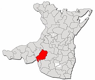
Deleni is a commune in Constanța County, Northern Dobruja, Romania. It is situated in the southern part of the county, 59 km (37 mi) west of Constanța.

Lorcha, or L'Orxa, is a municipality in the comarca of Comtat in the Valencian Community, Spain. As of the year 2021, it has a total population of 581.
Chinchali is a village in Raybag Taluk, Belagavi District, Karnataka, India. It is located near the state boundary with Maharashtra, approximately 84 kilometres north of the district seat Belgaum, and 10 kilometres northeast of the taluk seat Raibag. In the year 2011, the village has a population of 18,986.
Nazarezinho is a municipality in the state of Paraíba in the Northeast Region of Brazil. As of the year 2021, its total population is 7,271.
Cedral is a town and municipality in the Mexican state of San Luis Potosí in central Mexico. As of the year 2020, it has a total population of 19,840.
Mohare is a village in Bailhongal Taluk, Belagavi District of Karnataka, India. It is located near the state border with Maharashtra, about 26 kilometres east of the district seat Belgaum, and 16 kilometres northwest of the taluk seat Bailhongal. As of 2011, it has a total population of 2,365.

Pujut is a district of Central Lombok Regency, West Nusa Tenggara, Indonesia. Its administrative center is in the village of Sengkol. It borders Central Praya District to the north, East Praya District to the east, the Indian Ocean to the south, and the West Praya District to the west. In the year 2022, there were 120,538 inhabitants within the district.
Jale, or Jalley, is a town and the administrative center of Jale Block, Darbhanga District, Bihar, India. It is located to the north of Bagmati River, about 32 kilometres northwest of the district capital Darbhanga. The town was named after Jaleshwari sthan which is a pilgrimage site in rural area of Darbhanga. In the year 2011, it has a total population of 37,256.
Narmada is a town and administrative district (kecamatan) in West Lombok Regency, West Nusa Tenggara, Indonesia. It is located on the west side of the island of Lombok, approximately 10 kilometres east of Mataram, the provincial capital. In mid 2023, its population was 107,201.

Joachín is a locality in Tierra Blanca, Veracruz, Mexico. It is located in the Papaloapan region, about 31 kilometers northeast of Tierra Blanca. The town is located at an average elevation of 36 meters above the sea level. As of the year 2020, it had a population of 2,623.
Anger Gute Town Administration is a town in Anger Gute Town Administration, East Welega Zone, Oromia Region, Ethiopia. The town is located to the north of Didesa River and west of Anger Wenz River, with an elevation of 1,358 meters above the sea level. As of 2024, it had a total population of 65350.
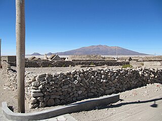
Coipasa is a rural municipality in Sabaya Province, Oruro Department, Bolivia. It is surrounded by Coipasa Lake on three directions, and has an average elevation of 3,709 meters above the sea level.
Morai is a village in Ambattur Taluk, Tiruvallur District, Tamil Nadu, India. It is located in the western suburb of Chennai, about 23 kilometres away from the city center. As of 2011, it had a total population of 10,873.
Dos Ríos is a locality in the municipality of Emiliano Zapata, Veracruz, Mexico. It is located on the southeastern part of the country, about 77 kilometers northwest of the city of Veracruz. As of the year 2020, it had a total population of 1,698.
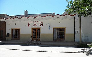
Matorrales is a town located in the Río Segundo Department, Córdoba Province, Argentina. It is located along the Provincial Route 10, about 98 kilometers southeast of the provincial capital Córdoba, at an average elevation of 250 meters above the sea level. As of the year 2010, it had a total population of 972.


