
Anna University is a state technical university in Tamil Nadu, India. The main campus is in Guindy, Chennai and the satellite campus is in Chromepet, Chennai. It was established on 4 September 1978. It is ranked the tenth institution in India overall by the National Institutional Ranking Framework, ranked fourth among universities, and ranked eighth in engineering. The main campus houses the College of Engineering, Guindy; Alagappa College of Technology, School of Architecture and Planning, and three technical departments of the University of Madras. The Madras Institute of Technology campus is located in Chromepet.
The College of Engineering, Guindy (CEG) is a public engineering college in Chennai, India and is India's oldest technical institution, founded in 1794. It is also the oldest technical institution to be established outside Europe.
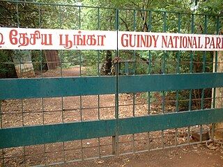
Guindy National Park is a 2.70 km2 (1.04 sq mi) protected area of Tamil Nadu, located in Chennai, India, is the 8th-smallest National Park of India and one of the very few national parks situated inside a city. The park is an extension of the grounds surrounding Raj Bhavan, formerly known as the 'Guindy Lodge', the official residence of the Governor of Tamil Nadu, India. It extends deep inside the governor's estate, enclosing beautiful forests, scrub lands, lakes and streams.

Guindy is one of the important neighborhoods of Chennai (Madras), Tamil Nadu, India. The Kathipara junction where Anna Salai, Mount-Poonamallee Road, Inner Ring Road, 100 Feet Road or Jawaharlal Nehru Road, and GST Road meet here. It is one of the important nodal points of road traffic in the metropolitan area. This junction serves as the entry point to the city limits from the suburbs. It is surrounded by Saidapet in the north, Kotturpuram and Adyar towards the east, Velachery in the south and Adambakkam and St. Thomas Mount in the west. Guindy is home to many important landmarks in the city, the most famous amongst them being the Guindy National Park — the only National Park in the country within city limits. It also serves as a main hub for several small and medium scale industries. Transportation to/ from the neighborhood is catered by Guindy railway station and Guindy metro station.

Alandur is a zone of Chennai corporation, and an urban node in Chennai district in Guindy division in the state of Tamil Nadu, India. As of 2011, Alandur had a population of 164,430. The town agglomeration of Alandur will have an estimated population of 300,000 by the year 2030. Alandur neighbours the St. Thomas Mount Cantontment, the Officers Training Academy of the Indian army and the nearby towns of Guindy and Adambakkam. M. G. Ramachandran, a former chief minister of Tamil Nadu started his political career by winning his first legislative election from Alandur in 1967. Alandur also holds famous landmarks of Chennai namely Nehru Statue and Kathipara Junction.

The Chennai Metropolitan Development Authority (CMDA), formerly known as the Madras Metropolitan Development Authority (MMDA), is the nodal planning agency of Chennai in the Indian state of Tamil Nadu. The CMDA administers the Chennai Metropolitan Region, spread over an area of 1,189 km2 (459 sq mi) and covers the districts of Chennai, Thiruvallur and Kancheepuram. It was set up for the purposes of planning, co-ordination, supervising, promoting and securing the planned development of the Chennai Metropolitan Area. It coordinates the development activities of the municipal corporations, municipalities and other local authorities.

Anna Salai, formerly known as St. Thomas Mount Road or simply Mount Road, is an arterial road in Chennai, India. It starts at the Cooum Creek, south of Fort St George, leading in a south-westerly direction towards St. Thomas Mount, and ends at the Kathipara Junction in Guindy. Beyond the Kathipara Junction, a branch road arises traversing westwards to Poonamallee to form the Mount-Poonamallee Road while the main branch continuing southwards to Chennai Airport, Tambaram and beyond to form Grand Southern Trunk Road. Anna Salai, which is more than 400 years old, is acknowledged as the most important road in Chennai city. The head offices of many commercial enterprises and public buildings are located along Anna Salai. It is the second longest road in Chennai, after Poonamallee High Road.
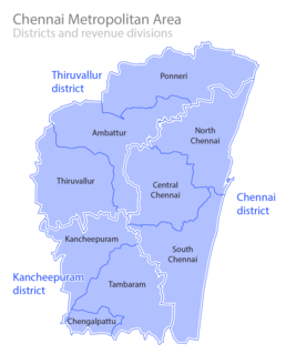
Metropolitan area includes a city and its suburbs. For the city, visit Chennai district
Sardar Patel Road is an arterial road in Chennai which runs from Mount Road eastwards through Guindy and Adyar for 3.2-kilometre (2.0 mi) up to the sea coast where it turns north and crosses the Adyar River to Raja Annamalaipuram.
Jafferkhanpet is a locality of Chennai, India. Guindy, K.K. Nagar, Ashok Nagar, MGR Nagar, Saidapet are its neighbourhood suburbs. You can reach Jafferkhanpet by travelling in the newly constructed Guindy flyover. This allows easier access to Vadapalani, Koyambedu bus stand in Chennai. Jafferkhanpet is twin locality of Ashok nagar
Mambalam taluk is a taluk of the city district of Chennai in the Indian state of Tamil Nadu. It was formed in December 2013 from parts of the former Egmore-Nungambakkam taluk and the Mambalam-Guindy taluk. It comprises the neighbourhoods of K. K. Nagar, Kodambakkam, Mambalam, Saligramam, Saidapet and Virugambakkam.
Ekkattuthangal, also known as Ekkaduthangal or Ekkatuthangal, is a neighborhood in Chennai city, Tamil Nadu, India. It is surrounded by Jafferkhanpet, Guindy and Ramapuram. Area pincode is 600032, and previously it was 600097.
Gerugambakkam is a residential-industrial neighborhood in the South-Western part of Chennai, a metropolitan city in Tamil Nadu, India.It belongs to the Alandur taluk of Chennai District, Tamil Nadu, India. The Alandur taluk, earlier a part of Kanchipuram district has now been annexed to the Chennai District. It forms a suburb of Chennai city.

Guindy railway station is one of the railway stations of the Chennai Beach–Chengalpattu section of the Chennai Suburban Railway Network. It serves the neighbourhood of Guindy, a suburb of Chennai. It is located at about 14 km from Chennai Beach terminus and is situated at NH 45 in Anna Salai, with an elevation of 12 m above sea level.
Alandur taluk is a taluk of the district of Chennai in the Indian state of Tamil Nadu. The centre of the taluk is the neighbourhood of Alandur. The headquarters of the taluk is Guindy division. On 4 January 2018, Chennai district was expanded by annexing Alandur taluk.
Sholinganallur taluk is a taluk of the city district of Chennai in the Indian state of Tamil Nadu. It was created in 2009 by the trifurcation of Tambaram taluk in Kanchipuram district. The centre of the taluk is the neighbourhood of Sholinganallur. The headquarters of the taluk is Guindy division. On 4 January 2018, Chennai district was expanded by annexing Sholinganallur taluk.
South Chennai is the new southern neighbourhoods of Chennai city, India. It is roughly the neighbourhoods and suburbs that lie south of the Adyar River. None of these places were part of Chennai Corporation before 1947 and became part of Chennai before 1990 when they existed as separate local bodies.
Guindy taluk is a taluk of the city district of Chennai in the Indian state of Tamil Nadu. It was formed in December 2013 from parts of the erstwhile Mambalam-Guindy taluk and the Mylapore-Triplicane taluk. It comprises the neighbourhoods of Adyar, Alandur, T. Nagar, Ekkaduthangal, Guindy and Kotturpuram.
Velachery taluk is a taluk of the city district of Chennai in the Indian state of Tamil Nadu. It was formed in December 2013 from parts of the erstwhile Mambalam-Guindy and Mylapore-Triplicane taluks. It comprises the neighbourhoods of Besant Nagar, Tharamani, Thiruvanmiyur and Velachery.


