Kanyakumari district, officially Kanniyakumari district, is one of the 39 districts of Tamil Nadu state and the southern most district in mainland India. It stands second in terms of population density among the districts of Tamil Nadu.[2] It is also the richest district in Tamil Nadu in terms of per capita income,[3][4] and also tops the state in Human Development Index (HDI), literacy, and education.[5][6] The district's headquarters is Nagercoil.
Kanyakumari district has a varied topography with the sea on three sides and the mountains of the Western Ghats bordering the northern side. Except for a small stretch of land to the east of Kanniyakumari town, almost the entire district is sandwiched between the Western Ghats and the Arabian Sea – the only district in Tamil Nadu state facing the Arabian Sea.
Historically, Nanjinad and Edai Nadu, which comprise the present-day Kanniyakumari district, were ruled by various Tamil and Malayalam dynasties: the Cheras, the Ay/Venad/Travancore dynasty, the Pandyans, the Chozhans and the Nayaks. A few artefacts have been unearthed by archaeological excavations.[7] It was part of the princely state of Travancore during the colonial times prior to India's independence;[8] four of the eight tehsils of Thiruvananthapuram district were separated from the erstwhile Travancore Kingdom to form the new district of Kanniyakumari, and they were made the part of Madras Presidency under recommendations from the States Reorganisation Commission in 1956. The Presidency was later renamed Tamil Nadu and Kanniyakumari, today, is one of the 38 districts of Tamil Nadu state.
The district is the birthplace of Ayyavazhi. Many historical assumptions persist in the district and state, which associate sages such as Agastya, Vyasa, Tolkappiyar, Avvaiyar and Valluvar with the district.
The area that comprises the current Kanniyakumari district was a part of the old Ay kingdom of the first and second Sangam ages. Following the decline of the Ay kingdoms, the area became Venad, with its capital Padmanabhapuram located North, North West of Nagercoil. The wealth of the Nanjilnadu beckoned many invaded kings including the Nayaks during the reign of Umayamma Rani. The Venad region was in anarchy before Marthanda Varma ascended the throne in 1729 CE. Under their rule anarchy was dominant in Kanniyakumari region. However, Marthanda Varma brought a sense of disorder under control by annexing the nearby territories, putting down the feudal lords and establishing the strong state of Travancore. He had also bought some portions of Kanniyakumari from the then viceroy making it the southern boundary. Under his rule, the district improved in a social context as well as economically. The famous battle of Colachel took place in the district. Later, the Maharajas of Travancore built the forts at Aramboly (Aralvaimozhy) to prevent any invasion from the Carnatic Kings. Key elements of Velu Thampi Dalawa's revolt occurred in the area and the English East India company's army under Col.
Leger broke through the fortifications and entered Travancore in 1810. In the year 1949, the area became a part of the reestablished Travancore Cochin state. The people of Agasteeswarem, Thovalai, Kalkulam and Vilavancode taluks, which formed the southern divisions of the former district of Trivandrum, were predominantly Tamil speaking people. The present Kanniyakumari district was historically part of the erstwhile Travancore State. Four Tamil-speaking taluks viz., Vilavancode, Kalkulam, Thovala and Agastheeswaram which now form the Kanniyakumari district was transferred to Madras State on 1 November 1956. The changes that were effected between the taluks and the villages as on 1 October 1956 are furnished in the fly-leaf to Table A-I.[9] An extreme agitation by Tamil speaking residents under the leadership of Marshal Nesamony took place for including Kanniyakumari within Tamil Nadu. Eventually the merger happened in 1956 based on language reorganisation of states.
Historically, Nanjilnadu (Agastheeswaram and Thovalai taluks) and Eda Nadu (Vilavancode and Kalkulam taluks) which comprises the present Kanniyakumari district. The district were ruled by various dynasties: Venad Kingdom, Travancore Kingdom, the Cheras, the Cholas, the Ays and the Nayaks. A few artefacts were unearthed by archaeological excavations in parts of the district. The district was part of the princely state of Travancore during the colonial times prior to India's independence; four of the eight tehsils of Thiruvananthapuram district were separated to form the new district of Kanniyakumari in 1956 following the demands of reunion made by the Tamil speaking majority people (about 70% of the population), who feels that their feelings were suppressed by the erstwhile Travancore Kingdom which has Malayalam-majority population. The four taluks were made the part of then Madras State under recommendations from the States Reorganisation Commission in 1956. The Madras State was later renamed Tamil Nadu in 1969 and Kanniyakumari, today, is one of the 38 districts of Tamil Nadu state.
The district is the birthplace of Ayyavazhi, the henotheistic belief initiated by Hari Gopalan Seedar, one among the 5 prime disciples of Ayya Vaikundar. The social, religious and cultural history of the 19th century Kanniyakumari district is intrinsically inter-twined with those of Ayyavazhi. Many historical assumptions persist in the district and state, which associate with sages namely Vyasa, Agastya, Tolkappiyar, Avvaiyar and Valluvar.
Kanniyakumari district has a varied topography with sea on three sides and the mountains of the Western Ghats bordering the northern side. Geologically, the landmass of the district is much younger when compared to the rest of state – faulted as late as 2.5 million years during the Miocene, after which numerous transgression, as well as regression of sea, had shaped the western coast of the district.[13]
The district can be categorised into three natural divisions:[14]
Mountainous Terrain: Located in the northern and north-eastern portion of the district, this area includes the northern parts of Vilavancode and Kalkulam taluks. It includes several impressive hilltops and is an extension of a larger mountain range to the north.
Fertile Sea-Coast: Stretching along the southern and South-eastern and south-western parts of the district, this coastal region is fringed with coconut trees. Although predominantly sandy, there are occasional slightly elevated patches of red cliffs.
Valleys and Plains: Situated between the mountainous terrain and the sea-coast, this area features rolling, undulated valleys and plains interspersed with rivers and streams.
Within the northern mountainous range of the district lies the scenic sanitarium of Muthukuzhivayal. South of Peermedu, this range stands out due to its significant breadth. The rugged landscape boasts bluff ridges and conical peaks, forming a continuation of the Western Ghats that stretches all the way to the Aralvaimozhi Pass. Notably, the perfectly detached Kattadimalai stands out as a prominent rocky mass. Continuing southward, a broken rocky spur shapes into Marunthuvazh Malai, situated approximately 7 kilometres northwest of Kanyakumari. The Vellimalai in Kalkulam taluk and the Maruntuvazh malai in Agastheeswaram taluk are important isolated hills. The variations in altitude and climate across the hilly terrain of the district have led to a diverse vegetation profile, showcasing distinct representations of different land types. The highest hill within the district is Mahendragiri (1654 meters) in Thovalai taluk, situated on the border between Kanniyakumari and Tirunelveli districts. Kalmalai (900 meters), Moliyadi (700 meters) located at the head of old Kulasekaram reserved forest area and Tadakai malai (960 meters) are some of the notable hills in the district.
The mountainous terrain in the northern and eastern portions of the district contains an extensive plateau amidst elevated hilltops. While most of the hills have steep slopes, some exhibit a more gradual spread. While the area is predominantly agricultural, numerous plantations and few handloom industries thrive in this region.[15] The central area of the district, particularly Agastiswaram taluk, consists of vast plains. This includes the plains at Vellimalai, Mylaudy and Derisanamcope.
The district features an extensive 68-kilometer coastline. Predominantly regular in its configuration, the coast showcases notable projections toward the sea at locations such as Kanniyakumari, Muttam, and Erayanthurai. Additionally, there are a few minor sea ports. The ancient port of Colachel stands as the sole natural port on the west coast of Tamil Nadu while Kanyakumari serves as another minor port, primarily catering to tourists. Another minor port at is situated along the edge of Manakudi Estaury. Kanyakumari is the only district in Tamil Nadu facing the Arabian sea.[16]
Rivers
Pazhayar, the southernmost river in India, originates from the secondary range of the Western Ghats, draining Mahendragiri peak and nearby estates. Flowing through Thovalai and Agastiswaram taluks, the Pazhayar significantly supports irrigation. Its course spans approximately 37 kilometres, ultimately joining the Manakkudy Lagoon at Thamaraikulam. Notable places along the river include Boothapandi, Thalakudi, Vadasseri, Nagercoil, and Suchindram.[17]
Kodayar originates east of Valia Malai peak within the southern part of the Muthukuzhivayal plateau and flows southwest through a wild tract. Two streams—one from Motavan Pothai and the other from Thacchamala hills—contribute to this river. The Pechiparai Dam intercepts the Kodayar, creating the Pachipparai lake. With a rocky bed, steep banks, sharp curves, and frequent falls, the Kodayar remains largely untamed except for a few kilometres near its end. The Tirparappu Waterfalls along this river stands at approximately 13 meters. After covering 32 kilometres in Kalkulam and Vilavancode taluks, the Kodayar merges with the Paraliyar to form the western Tambaraparani.[18]
Originating north of Mahendragiri, the Paraliyar, another major river of the district flows southwesterly and passes out of the forest area a mile above Ponmanai[19] where it encounters the Perunchani Dam. The Left Bank Channel supplies water from the Pechipparai reservoir before reaching the weir known as Puthen dam. The ancient Pandyan dam, built in Pandiyan era, across the Paraliyar in Kalkulam taluk, along with the Pandyan Kal and related irrigation works, constitute one of the region's ancient irrigation systems. About a kilometre downstream from the Pandyan dam, the river meets the 250-year-old Puthen dam.[20] The river runs through the Kalkulam and Vilavancode taluks and covers 37 kilometres before joining the Kodayar near Thiruvattar, forming the western Thamirabarani River. It flows southwest through Kuzhithurai, Munchirai and evantually into the Thengapattanam estaury where it meets the sea.
Valliyar a minor river originates at an altitude of 950 m in the Velimalai hills[21] and passes through Kothanalloor, Kalkulam, Eraniel, Thalakulam and Manavalakurichi before joining the Arabian Sea at Kadiapattanam. Along the way, it merges with the Thuvalar, another small river originating from the Mampazhathurai hills. Mullayar another minor river flows approximately 11 kilometres through Vilavancode taluk and joins the western Tambraparani near Thikkurichi.[22]
Geology
The district features diverse topography with its northern and western regions consist of hilly terrain and forests, while the southeastern and central parts are characterised by agricultural lands. Along the southern border lies an extensive sea-shore with scattered rocky ridges, interspersed by valleys and plains. Additionally, sandy beaches and isolated boulders define the southern coastline.[23]
The Peninsular India is typically described as a highland with faulting on both sides. During the Archaean Eon, the eastern coast experienced faulting, whereas the faulting of the western coast, including the major parts of the Kanyakumari district, occurred later—approximately 25 million years ago—during the early Miocene era. Subsequent transgressions and regressions of the sea led to the formation of various sedimentary layers.
Over time, the sea receded, resulting in uplifted land masses. Evidence of this uplift includes deeply entrenched streams, waterfalls, high hanging valleys, alluvial flats, and marine sediment patches at higher elevations. Notably, shelly limestone formations in Kanyakumari further support the theory of land uplift in this area. The uplift likely occurred in stages, rejuvenating older streams. The wind gap at Mekkode resulted from river piracy, where the Paraliyar was captured by the Kodayar, possibly during the Tertiary period. The straight west coastline, uninterrupted by breaks, suggests faulting during the Pliocene epoch. Similarly, changes in the Kodayar river's course—from northward to northeast to southwest indicate faulting along its path.
Geologically, the region features two main rock groups: the Khondalites, and Charnockites while a third group, Migmatites[24] is also found. The Khondalites, composed of garnetiferous Sillimanite-GraphiteGneisses and Garnet-Biotitegneisses, dominate a significant portion of the district.[25] Meanwhile, the Charnockites are exposed in areas between Padmanabhapuram, Aralvaimozhi, Kulasekaram, Thuckalay, and Rajakkamangalam. The distinctive occurrence of feldspathic granites across a significant portion of this region indicates that the rocks underwent intense isoclinal folding, resulting in repeated bands. These folds align in a northwest–southeast direction and may have subsequently experienced cross-folding.[26] These charnockites also occur as lenses and patches within the khondalites. Additionally, thin Pegmatite bodies and quartz veins intrude the khondalites. Tertiary-age Varkala beds appear as thin cappings south of Kaliyakkavilai near the coast.[27]
As part of the Western Ghats, one of the world's eight hottest biodiversity hotspots,[29] this district boasts a rich diversity of flora and fauna, many of which are endemic to the region.[30] The area is home to several endangered and threatened species, including the Indian Bison, Indian Rock Python, Lion-tailed Macaque, and Nilgiri Tahr. The Kanyakumari Wildlife Sanctuary, a protected area covering 457.78 km2, is situated in the northern and north-western parts of the district. They constitute the southern section of the Agastyamalai region, bordered by Kerala's Neyyar Wildlife Sanctuary to the west and Kalakkad Mundanthurai Tiger Reserve to the east. [31] Seven rivers including the Pahrali and Thamirabarani have their origin in this forest.[32] The forests and jungles of Kanyakumari district host approximately 600 species of timber trees and 3,500 other plant species.[33] The wetlands of Suchindrum and Arumanallur alone support numerous variety of floral and faunal species across hundreds of genera.[34][35] New species are frequently being identified throughout the region.[36][37]
Forests
The Western Ghats at Pechiparai, Kanniyakumari District
Out of the total land area of 168,356.216 hectares, approximately 48,423 hectares are covered by forests. Reserved forests account for 44,799 hectares, while 3,605 hectares are unclassed forests. Additionally, there are 19 hectares of reserved lands. Most of the forests in the district are situated on slopes of hills and plateaus, benefiting from high rainfall and serving as catchment areas for numerous streams and rivers. The forests in the district are lush and virgin and is 75 million years old. The forest of this region comes under Boothapandy Mahendra-giri Reserve forest and is managed by the District Forest Officer with Headquarters at Nagercoil.[38]
The jungles host around 600 species of gigantic timber trees and 3,500 other plants, many of which hold significant economic value. Notable timber trees include teak, rosewood (blackwood), Jungle Jack, Malabar ebony, Adina cordifolia, Karumaruthu, and Vengai. Softwood varieties like Bombax ceiba and glossy-leaved jack are also abundant, along with reeds, bamboos, and sandalwood. Plantations of cardamom and tea thrive at higher elevations, while pepper, rubber, ginger, and turmeric flourish in lower areas.[19] Due to various local geological factors, the forests in the Kanyakumari division encompass 14 distinct types, based on the Champion and Seth's classification[39] ranging from lush tropical wet evergreen forests to tropical thorn forests, all within a relatively small area.[38] The region hosts a diverse array of plant species, with its natural vegetation encompassing southern thorn forests, dry deciduous forests, moist deciduous forests, semi-evergreen forests, and evergreen hill sholas interspersed with grassy downs.[40]
The Hills of the region harbour a unique xerophytic flora, adapted to arid conditions. At higher elevations, large grasses like Andropogon, Panicum, lemon grass, and fodder grass thrive, creating a verdant carpet. Closer to the base, shrubby forms—such as species of Phoenix, Cycas, and Inthai—find their niche. Abundant bamboo clumps (including Ochlandra) and dense cane growths (both bamboo family members) abound. Sheltered beneath the grasses, ephemeral annual herbs and herbaceousperennials emerge during favourable seasons. In the sheltered valleys, extensive paddy cultivation sustains the region. Paddy remains the staple food crop. Tapioca, the second most important food crop, thrives primarily in Kalkulam and Vilavancode taluks. Palmyrah and coconut groves dot the plains and coastal regions.[44]
Tigers are found around the Black Rock estate and descend to lower reaches during October and November, occasionally entering bordering villages. Panthers inhabit moist deciduous forests and often prey on domesticated animals. Bears usually reside at elevations above 3,000 feet but sometimes descend to lower levels. Wild dogs are found in the lower hills of the Muthukuzhi valley, while the Indian Grey Mongoose and Jungle Cats are common in the low country and jungles. Jackals and foxes are also common. The South Indian Hedgehog is found throughout the district. Bats are very common, with four different species present. Among squirrels, the Palm Squirrel is most commonly found in the countryside, while the Malabar Squirrel inhabits the jungles. The Indian Porcupine is found throughout the forests. Rats, mice, and hares are very common, with Black rat and Mus booduga found across the district.[54][55]
Elephants are abundant in the upper reaches of Asambu and Veerapuli reserves and are occasionally spotted around Kodayar, Perunchani and Balamore areas. Deer are seen throughout the hilly forests, with three species present: The Spotted Deer, Sambur, and the Barking Deer. The Muthukuzhi valley and the entire Asambu region are favoured by Sambur deer. The Gaur is the largest of the two bovines found in the forests, living in rock caves on hills up to an elevation of 5,000 feet. Small herds of bison frequent the sholas and grassy areas around the Muthukuzhi valley and the higher reaches of Asambu. The wild goat is usually confined to grassy slopes. Wild bears are found on the hills and jungles in herds. Additionally, aquatic dolphins and porpoises are found in river mouths and backwaters. Indian pangolins are also present in forests and surrounding valleys.[56]
The Thiruvalluvar Statue, or the Valluvar Statue, is a 41-metre-tall (133ft) stone sculpture of the Tamil poet and philosopher Valluvar, author of the Tirukkural, an ancient Tamil work on Dharma and morality. It is located atop a small island near the town of Kanniyakumari on the southernmost point of the Indian peninsula on the Coromandel Coast, where two seas (the Bay of Bengal and the Arabian Sea) and an ocean (the Indian Ocean) meet. The statue was sculpted by the Indian sculptor V. Ganapati Sthapati, who also created the Iraivan Temple, and was unveiled on the millennium day of 1 January 2000 by the then Chief Minister M. Karunanidhi. It is currently the 25th tallest statue in India.
Thirparappu Waterfalls
Thriparappu falls
Thirparappu Waterfalls are waterfalls in Kanniyakumari District. It is also known as 'Courtallam of Kanniyakumari'. The Mahadevar Temple is very near to the waterfalls. The waterfalls is 7km (4.3mi) from Kulasekaram. Actually the waterfalls is exactly 34km from city centre, Nagercoil.
Manimedai
Manimedai is situated in the central part of Nagercoil. Manimedai literally means High Clock. It is the symbol of the Nagercoil Town. A clock is placed in a High Clock gauge, so the place becomes Manimedai. The construction of the Clock gauge began in 1892 in the period of Travancore Maharajas. After construction, it was opened by His Highness Sree Moolam Thirunal Varma, the King of Travancore. The clock placed in the gauge was gifted to the English missionary in Nagercoil.
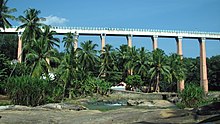
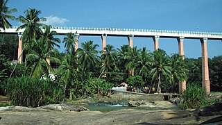
Mathur Aqueduct
Mathur Aqueduct
The Mathur Aqueduct was built to pass the cultivable water between two mountains. Mathur Aqueduct was built between Aruvikkarai and Mudhalaaru in Paraliyaru River. The aqueduct was built by Former Chief Minister of Tamil Nadu Perunthalaivar Thiru Kamarajar. Mathur aqueduct was South Asia's largest aqueduct. The aqueduct is 1,240ft (380m) long, 101ft (31m) high with 28 giant pillars. It is 3km (1.9mi) from Thiruvattar and 26km from Nagercoil.
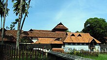
Padmanabhapuram palace
Padmanabhapuram Palace
Before centuries, the houses that has all the facilities are known as Palaces. The rulers of states, the Kings resides in such Palaces. Padmanabhapuram Palace was once the official residence of Travancore Kings. Padmanabhapuram Palace was built in Kerala styled Architecture with woods. The palace was built in 18th century by Travancore King Thiru Anizham Thirunal Marthanda Varma. The palace was situated in 6.5 acres in 186 acres fort. The palace is under the control of Kerala Government. The palace is situated just 2km from Thuckalay.
Udayagiri Fort
Udayagiri Fort was situated just 10km from Parvathipuram. The fort was situated in 22½ hectares in a place called Puliyoorkurichi. The Fort is maintained by the Ministry of Forests, Government of Tamil Nadu.
Vattakkottai
Inside of the fort.
The word 'Vattakkottai' means Circle Fort and is circular. The Fort was constructed along the seashore in the East coast. The fort was situated in 3½ acres with compound stones constructed for 25 meters in height and constructed by Travancore Army Chief Dilanai. The fort is under the control of the Archaeological Department, Government of India. It is situated 6km north of Kanniyakumari and 2km south of Anjugramam.
Vivekananda Rock
Rock Memorial
Vivekananda Rock Memorial is a monument in Vavathurai in Kanniyakumari District. It is located just 500 meters east in the mainland of Vavathurai. The rock was built in 1970 in honour of Swami Vivekananda who is said to have attained enlightenment on the rock. Vivekanand was a disciple of Swami Ramakrishna Paramahansa.[59] According to local legends, Goddess Kumari performed Tapas in devotion of lord Shiva in these rocks. The rocks are surrounded by the Laccadive Sea.
Chitharal Jain Rock Cut Temple
Jain bas-relief on the north side outer wall of the cave temple.
It is famous for the Rock-cut temple. Hill rock at Chitharal has a cave containing Rock-cut sculptures of Thirthankaras and attendant deities carved inside and outside dating back to 9th Century A.D by King Mahendra Varman I.[60]
Administrative divisions
For administrative purposes, the district comprises six taluks and nine blocks. There is a municipal corporation in the district which is Nagercoil. There are also four municipalities and 51 Town Panchayats.[61]
At the lower levels of administration, there are 95 village panchayats.[62]
According to 2011 census, Kanniyakumari district had a population of 1,870,374 with a sex-ratio of 1,019 females for every 1,000 males, much above the national average of 929.[64] A total of 182,350 were under the age of six, constituting 92,835 males and 89,515 females. Scheduled Castes and Scheduled Tribes accounted for 3.97% and 0.39% of the population respectively. The district had a total of 483,539 households. There were a total of 679,620 workers, comprising 12,229 cultivators, 51,350 main agricultural labourers, 21,078 in household industries, 468,001 other workers, 126,962 marginal workers, 3,381 marginal cultivators, 21,517 marginal agricultural labourers, 14,711 marginal workers in household industries and 87,353 other marginal workers.[64]
The average literacy rate of Kanniyakumari in 2011 was 91.75 compared to 87.55 in 2001. If things are looked out at gender-wise, male and female literacy were 93.65 and 89.90 respectively. For the 2001 census, the same figures stood at 90.37 and 84.79 in Kanniyakumari District. The total number of literates in Kanniyakumari District were 1,548,738 of which male and female were 780,541 and 768,197 respectively. In 2001, Kanniyakumari District had 1,308,322 in its district.
Tamil is the most widely spoken language in Kanniyakumari district, though there is significant minority (5.76%) of Malayalam speakers (Malayalis), living mainly along the Kerala border.[65] Kanniyakumari district has a Tamil dialect which is different from other part of Tamil Nadu, since it has a little Malayalam influence.[66] English can be understood by two-thirds of the district's population.[67]
Urban population
Out of the total Kanniyakumari population for 2011 census, 82.33 per cent lives in urban regions of district. In total 1,539,802 people lives in urban areas of which males are 761,407 and females are 778,395. Sex ratio in urban region of Kanniyakumari district is 1022 as per 2011 census data. Similarly child sex ratio in Kanniyakumari district was 966 in 2011 census. Child population (0–6) in urban region was 148,570 of which males and females were 75,573 and 72,997.
This child population figure of Kanniyakumari district is 9.93% of total urban population. Average literacy rate in Kanniyakumari district as per census 2011 is 91.96% of which males and females are 93.92% and 90.06% literates, respectively. In actual number 1,279,358 people are literate in urban region of which males and females are 644,109 and 635,249, respectively.
Rural population
As per 2011 census, 17.67% population of Kanniyakumari districts lives in rural areas of villages. The total Kanniyakumari district population living in rural areas is 330,572 of which males and females are 164,938 and 165,634 respectively. In rural areas of Kanniyakumari district, sex ratio is 1004 females per 1000 males. If child sex ratio data of Kanniyakumari district is considered, figure is 957 girls per 1000 boys. Child population in the age 0-6 is 33,780 in rural areas of which males were 17,262 and females were 16,518.
The child population comprises 10.47% of total rural population of Kanniyakumari district. Literacy rate in rural areas of Kanniyakumari district is 90.76% as per census data 2011. Gender wise, male and female literacy stood at 92.39 and 89.16 per cent, respectively. In total, 269,380 people were literate of which males and females were 136,432 and 132,948, respectively.
As per 2011 census, total population of the district is 1,870,374, among them 909,872 (48.7%) are Hindus, 876,299 (46.9%) are Christians, 78,590 (4.2%) are Muslims, 438 (0.02%) are Buddhists, 160 (0.01%) are Sikhs, 156 (0.01%) are Jains, 10 (0.001%) are Others and 4,849 (0.26%) are "not stated".[68] The western talukas of the district are Christian-majority, while the eastern talukas are Hindu-majority. Some of the Hindu population follows Ayyavazhi. Protestants and Catholics are both present in the Christian population, with Protestants largely from the Nadar community and Catholics from the fishermen community. Some Syrian Christians also live here.
The Mandaikadu festival is celebrated in March by people of the district and by those in Kerala. Traditionally, participants would chant while walking while others would provide them with butter, milk, water, jaggery, and coffee. The festival, which is celebrated for ten days, later became a social function, especially on Sunday.
Kollemcode Festival
The Kollemcode Tookam festival is another famous festival celebrated by the people of the district and also by the people from the nearby Thiruvananthapuram district of Kerala state. It is celebrated for 10 days during the month of March/April with the famous Child Tookam taking place on the 10th day corresponding to Meena Bharani as per the Malayalam calendar.
The "ezhunnalath" or elephant procession festival of Alappancode Sree Eeswarakala Bhoodhathan Temple located at Anducode is also another major festival of the district. It is the largest elephant festival of Tamil Nadu and is often considered Tamil Nadu' Thrissur Pooram.
Ayya birthday Celebration
The Ayya vaikunda Avataram of Ayyavazhi is widely celebrated throughout the district.[69][70] The Kodiyettru Thirunal is celebrated in the religious headquarters of Swamithope pathi and attracts large crowds[71] from Tamil Nadu and across India.[72][73][74] Onam is also celebrated in many places throughout Kanniyakumari district, especially in the western part of the district.
Sucheendrum temple car festival
The Temple Chariot festival
the religious significance of the Thanumalayan Temple stems from the fact that the main statue of linga represent Siva (Sthanu), Vishnu (maal) and Brahma (Ayan) (as well as giving the temple its name). The representation of the three central gods of Hinduism in one linga makes it unique in India. The 10-day Car Festival celebrated in this temple during between December and January every year attracts crowds of thousands of people. Special worship practices are followed and the festival images of Sthanumalayan, Aram valartha Nayagi and Vinayagar are taken in the temple car around the streets of the temple. Another festival known as Teppam is celebrated during between April and May every year. The Sanskrit work Sucindrastalamahatmya gives a full-fledged legendary account of the origin and development of this temple.[75]
Kottar, St. Francis Xavier's temple festival
Church records indicate that St. Xavier Church was built in 1600. In 1865, the Shrine of Mary was renovated and enlarged. In 1930, the church was raised to the status of a cathedral. The annual festival is celebrated during November – December lasting for 10 days. The people from various place and near by state kerala people also join during the festival. During the festival other religious people also Get together. and helping to organise the Festival by vaious ways.
Kanya Kumari, Bagavathi Amman temple festival
Chitra Pournima Festival: on the Full moon day in May
Navaratri festival: 9 day festival in (September–October). The music artists get an opportunity to offer their artistic skill to the goddess by performing in the Navarathri Mandapam.
Vaisakha festival: 10-day festival in May–June culminating by a Thoni Ezhunellathu in May–June. During this festival Devi will be taken in procession both in the morning and evening, during Aaraatu the eastern door is opened. On the ninth day, the Thoni Ezhunellathu takes place. Devi will be taken round the water on the western part in a boat.[76]
Kalabham festival: The idol is smeared in Sandal paste in the last Friday of the month of Karkidaka or Aadi, in July–August.[77]
Onam festival
Onam is an annual harvest and cultural festival related to Hinduism that is celebrated mostly by the people of Kerala. The people of Kanyakumari district also celebrate this fest (formerly Kanyakumari district was part of Kerala). The date of Onam celebration is based on the Panchangam and falls on the 22nd NakshatraThiruvonam in the month Chingam of the Malayalam calendar, which in the Gregorian calendar falls between August and September.[78][79]
Kuzhithurai Vavubali Exhibition
annual Karkida Vavu Bali (Shradham for the ancestors held during the Mahalaya Amavasai) ceremony that is held here during July/Aug (Malayalam month Karkidakam). Along with the religious ceremony during this time, the famous annual exhibition fair - Vavubali Mela / Exhibition - was started by Shri. T.C Kesava Pillai, MLC from Kuzhithurai in the 1900s. Today this is continued by the Kuzhithurai Town Municipality.[80] The people from various place and near by state kerala people also join during the festival. During the festival other religious people also Get together.
Marungoor Soora Samharam and mylaudy Arattu fest
The Subramania Swamy Temple, which is situated atop a small hillock is worth a place to visit. This temple area is called as Kumarapuram thoppur, Marungoor. Because of Kumaran's (Subramania swamy) name. Shashti and Surasamharam are the famous festivals at this temple. The famous kandhashashti kavasam festival is very popular over here and celebrated as major festival. after 5 days later Subramania Swamy come to mylaudy by the silver horse car and bath in Mylaudy river and abishekam with 17 products. Every year it was celebrated only in kanyakumari district after 5 days of Surasamharam fest. The people from various place join during the festival. During the festival other religious people also Get together.
Transport and highways
Roadways
There are two major National Highways (NH) roads originating from Kanniyakumari town. One is the National Highway 44 which connects Kanniyakumari with Srinagar of Jammu & Kashmir. NH 44 connects North India with South India. The road passes through Madurai, Hosur, Bengaluru, Hyderabad, Nagpur, Jhansi, Delhi and Jalandhar. It covers 3745 kilometres. The other is the National Highway 66 that connects Kanniyakumari with Panvel (38km from Mumbai) in Maharashtra. NH 66 roughly runs north–south parallel to the western ghats. It passes through Thiruvananthapuram, Kochi, Kozhikode, Mangaluru, Udupi, Margoa and Ratnagiri. Nagercoil, the district capital is well connected with the rest of Tamil Nadu.
The nearest international airport is Trivandrum International Airport which is 76km from Kanniyakumari. The Civil Aviation Ministry is planning to construct an airport near Swamithoppu in Kanniyakumari District as the initiative attracts international tourists to the district.[82]
Education
According to the 2011 Census, Kanyakumari has a literacy rate of 91.7%, compared to Tamil Nadu's literacy rate of 80.1%. The district has recorded the highest male literacy rate of 92.4% and the female literacy rate of 89.2% in rural areas, as well as the highest female literacy rate of 90.1% in urban areas.[83]
The district is home to many well-established institutions like colleges such as Scott Christian College (est. 1809), South Travancore Hindu College (est. 1952), Holy Cross College (est. 1965), Women Christian College, Sivanthi Aditanar College (est. 1984) and schools such as Ringletaube Higher Secondary School (est. 1809), Scott Christian Higher Secondary School (est. 1819), Duthie Girls School (est. 1819), St. Joseph's Convent Higher Secondary School (est. 1910), Carmel Higher Secondary School (est. 1922), S.L.B. Government Higher Secondary School (est. 1924), S.M.R.V. Higher Secondary School (est. 1919).
Rainfall
Achankadu hill is the tallest mountain peak in the district with a height of 1828m. Hilly regions like Upper kodayar, Muthukuzhivayal and Achankadu hills receive more than 5000mm of annual rainfall which makes the region one of the wettest regions in Tamil Nadu. Kanniyakumari town which is located on the leeward side with no tall mountain ranges receives less rainfall in the district. Pechiparai, Chittar dams I & II, Perunchani dam and Surulacode receive annual rainfall between 2500 and 3000mm. Kanniyakumari is the only district in Tamil Nadu that benefits receiving from both the South-West and North-East monsoon, so Kanyakumari District rains in all seasons.
The Kingdom of Travancore, also known as the Kingdom of Thiruvithamkoor or later as Travancore State, was an Indian kingdom that lasted from c. 1729 until 1949. It was ruled by the Travancore Royal Family from Padmanabhapuram, and later Thiruvananthapuram. At its zenith, the kingdom covered most of the south of modern-day Kerala and the southernmost part of modern-day Tamil Nadu with the Thachudaya Kaimal's enclave of Irinjalakuda Koodalmanikyam temple in the neighbouring Kingdom of Cochin. However Tangasseri area of Kollam city and Anchuthengu near Attingal in Thiruvananthapuram were parts of British India.
Nagercoil, also spelt as Nagarkovil, is a city and the administrative headquarters of Kanyakumari District in Tamil Nadu state, India. Situated close to the tip of the Indian peninsula, it lies on an undulating terrain between the Western Ghats and the Arabian Sea.
Travancore–Cochin, officially the United State of Travancore and Cochin and later the State of Travancore–Cochin, was a short-lived state of India. It was formed through the merger of two former kingdoms, Travancore and Cochin on 1 July 1949. Its original capital was Thiruvananthapuram.
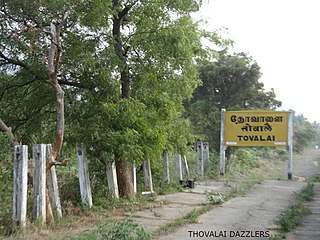
Thovalai is a small village located in Kanyakumari district, Tamil Nadu, India. The area is well known in India for its production of flowers, especially jasmine. The taluk was among the four in Thiruvananthapuram district that with the passage of the States Reorganisation Act of 1956 were transferred from Thiruvananthapuram district, Travancore-Cochin State to the newly created Kanyakumari district of Madras State.
Padmanabhapuram is a town and a municipality near Thuckalay in Kanyakumari district in the Indian state of Tamil Nadu. As of 2011, the town had a population of 21,342. Padmanabhapuram was the capital of Travancore state in the past. In 1795, the King of Travancore, Rama Varma (known as Dharma Raja moved the capital from Padmanabhapuram to Thruvananthapuram. At that time the boundaries of Travancore state included half the area of modem Kerala state. In 1947, after independence, Padmanabhapuram became part of Travancore-Cochin state When Indian states ware reorganized on the basis of language. In 1957, Padmanabhapuram along with other Tamil-speaking areas were ceded to Madras State, while the Malayalam-speaking areas became part of Kerala. Later the name of Madras State was changed to Tamil Nadu.
Marthandam is a major trade centre in Kuzhithurai municipality across National Highway in the Kanyakumari district of Tamil Nadu, India. Formerly known as Thoduvetty, it was a portion of Kanyakumari district which was added to the state of Tamil Nadu on 1 November 1956.
The Adikesava Perumal Temple is a Hindu temple located in Thiruvattar, Kanyakumari district, Tamil Nadu, India and is one of the 108 Divya desams, the holy sites of Hindu Vaishnavism according to existing Tamil hymns from the seventh and eighth centuries C.E. The temple is one of the historic thirteen Divya Deshams of Malai Nadu. The temple is a picturesque setting surrounded on three sides by rivers namely, It was the Rajya Temple and Bharadevatha shrine of Erstwhile Travancore. After state reorganisation, the temple handed over to Tamilnadu H&RCE Dept. The presiding Vishnu in the form of Ananthapadmanabhan/Adikeshavaperumal is believed to be older than Padmanabhaswamy Temple in Thiruvananthapuram. Since Vishnu resides here in a reclining position, and is surrounded by rivers, the temple is called as "The Srirangam of Chera Kingdom".
Colachel is a coastal town in the far south of India, located in the Kanyakumari district of Tamil Nadu. It is a natural harbor on the Malabar coast, located 20 km north-west of Kanyakumari, the southernmost tip of India. As of 2011 the municipality had a population of 23,227 and a metropolitan population of 47,007.
Thiruvithamcode, is a small panchayat town located in the Kanyakumari district of the Indian state of Tamil Nadu. Thiruvithamcode is about 20 km from Nagercoil and 2 km from Thuckalay.
Mylaudy is one of the town panchayats in Kanniyakumari district in the Indian state of Tamil Nadu. It is a municipality rich in fields, mountains, rivers and natural resources. Before 1950, Mylaudy was part of South Travancore. Now it is in Kanniyakumari district of Tamil Nadu.
Mathur Aqueduct is an aqueduct in Thiruvattar taluk of Kanniyakumari district of Indian state of Tamil Nadu. It was built in 1966 over the Pahrali River and takes its name from Mathoor, a hamlet near the aqueduct, which is about 3 km from Thiruvattar town and about 60 km from Kanniyakumari.
Kalkulam is a small village located in Kalkulam taluk, Kanyakumari district, Tamil Nadu, India. The taluk was among several in Thiruvananthapuram district that with the passage of the States Reorganisation Act of 1956 were transferred from Thiruvananthapuram district, Travancore-Cochin State to the newly created Kanyakumari district of Madras State.
Vilavancode, also spelt as Viḷavaṅgōḍu, is a town panchayat in Kanyakumari district in Tamil Nadu state, India. It is part of territory among several taluks that were with the Thiruvananthapuram district that with the passage of the States Reorganisation Act of 1956 transferred from Thiruvananthapuram district, Travancore-Cochin State to the newly created Kanyakumari district of Madras State.
A. Nesamony, sometimes known as Marshal Nesamony, was a political leader from Kanyakumari district in Tamil Nadu, India. He was the second son of Kesavan Appavu Nadar, born on 12 June 1895 at Nesarpuram, Palliyadi in Vilavancode Taluk, Kanyakumari district. He graduated from Maharaja's College in Thiruvananthapuram, and studied at law college in Thiruvananthapuram. He began practising in 1921. He was among those involved with the merger of four Taluks from Southern Travancore to Tamil Nadu.
Agasteeswaram taluk is a taluk located in Kanyakumari district, Tamil Nadu, India. The headquarters of the taluk is the town of Nagercoil. The taluk was among several in Thiruvananthapuram district that with the passage of the States Reorganisation Act of 1956 were transferred from Thiruvananthapuram district, Travancore-Cochin State to the newly created Kanyakumari district of Madras State.
Kallkkulam taluk is a taluk of Kanyakumari district of the Indian state of Tamil Nadu. The headquarters of the taluk is the town of Kallkkulam.Up to 1957, Kallkkulam Taluk formed part of the Travancore Kingdom and subsequently the Travancore-Cochin State. It was when the States were divided on linguistic basis that Kallkkulam, Thovalai, Vilavancode, and Agastheeswaram Taluks of the erstwhile Thiruvananthapuram District of the then Travancore-Cochin State were included in the then Madras State as Kanyakumari District.
Vilavancode taluk is a taluk located in Kanyakumari district, Tamil Nadu, India. The headquarters of the taluk is the town of Vilavancode. The taluk was among several in Thiruvananthapuram district that with the passage of the States Reorganisation Act of 1956 were transferred from Thiruvananthapuram district, Travancore-Cochin State to the newly created Kanyakumari district of Madras State. The present Tahsildar of Vilavancode is Mr. Abraham Denny
Eraniel Railway station is an NSG–5 category Indian railway station in Thiruvananthapuram railway division of Southern Railway zone. It in Eraniel is the most important railway station of Kallkkulam taluk of Kanyakumari district in the Tamil Nadu state of India. All daily trains passing through the station halts in Eraniel station. The famous Mandaikadu Bagavathi Amman Temple, Colachel Port, I.R.E Industries in Manavalakurichi and Padmanabhapuram Palace are situated nearby the station. The station also is the nearest railhead for two municipalities – Padmanabapuram, Colachel and for 25 villages.This Railway station is very useful to go work in morning time.
The Travancore Tamil Nadu Congress (TTNC) was a political party in the Indian state of Travancore-Cochin. The party was founded by Sam Nathaniel and led by A. Nesamony, both natives of Palliyadi.
The present-day Kanyakumari district and parts of Tenkasi district of Tamil Nadu state in India was originally a part of the Travancore-Cochin state. Between 1945 and 1956, especially after the Government of India announced plans to reorganize states along linguistic lines, the people of Tamil-majority Kanyakumari campaigned for its inclusion in the Madras State instead of the Malayalam-majority Kerala state. In Tamil, the campaign is also known as Therkku Ellai Porattam.
↑ Gopalakrishnan, M. (13 January 1995). Gazetteers of India - Kanyakumari District. Chennai: Commissioner of Archives & Historical Research, Government of Tamil Nadu. p.11.
↑ M. Gopalakrishnan (13 January 1995). Gazetteers of India - Kanyakumari District. Chennai: Commissioner of Archives & Historical Research, Government of Tamil Nadu. p.23.
↑ M. Gopalakrishnan (13 January 1995). Gazetteers of India - Kanyakumari District. Chennai: Commissioner of Archives & Historical Research, Government of Tamil Nadu. p.25.
↑ M. Gopalakrishnan (13 January 1995). Gazetteers of India - Kanyakumari District. Chennai: Commissioner of Archives & Historical Research, Government of Tamil Nadu. pp.25–26.
↑ M. Gopalakrishnan (13 January 1995). Gazetteers of India - Kanyakumari District. Chennai: Commissioner of Archives & Historical Research, Government of Tamil Nadu. p.26.
1 2 Gopalakrishnan, M. (13 January 1995). Gazetteers of India - Kanyakumari District. Chennai: Commissioner of Archives & Historical Research, Government of Tamil Nadu. p.16.
↑ Gopalakrishnan, M. (13 January 1995). Gazetteers of India - Kanyakumari District. Chennai: Commissioner of Archives & Historical Research, Government of Tamil Nadu. p.17.
↑ Gopalakrishnan, M. (13 January 1995). Gazetteers of India - Kanyakumari District. Chennai: Commissioner of Archives & Historical Research, Government of Tamil Nadu. p.18.
↑ Gopalakrishnan, M. (13 January 1995). Gazetteers of India - Kanyakumari District. Chennai: Commissioner of Archives & Historical Research, Government of Tamil Nadu. p.27.
This page is based on this Wikipedia article Text is available under the CC BY-SA 4.0 license; additional terms may apply. Images, videos and audio are available under their respective licenses.