Kanyakumari, officially Kanniyakumari, also known as Cape Comorin, is a city in Kanyakumari district in the state of Tamil Nadu, India. It is the southernmost tip of the Indian subcontinent and the southernmost city in mainland India, and thus referred to as "The Land's End". The city is situated 90 kilometres (56 mi) south of Thiruvananthapuram city, and about 20 kilometres (12 mi) south of Nagercoil, the headquarters of Kanyakumari district.

Namakkal is a city and the headquarters of Namakkal district, Tamil Nadu. It is the first ISO 14001-2004 certified municipality in Asia for environmental management, specifically the provision and maintenance of water supply, solid waste and sewage management, town planning, lighting and other social services. Namakkal is known as the Egg City due to its large egg production and Transport city.

Mettur is an industrial and tourist town located in the Salem district in the state of Tamil Nadu, India. It is best known for the Mettur Dam which is the largest dam in south India.

Padmanabhapuram is a town and a municipality near Thuckalay in Kanyakumari district in the Indian state of Tamil Nadu. As of 2011, the town had a population of 21,342Padmanabhapuram mes the capital of Travancore state in the past in 1795, the King of Travancore, Rama Varma (known as Dharma Raja moved the capital hom Padmanabhapuram to Thruvananthapuram. At that time the boundaries of Travancore state included half the area of modem Kerala state. In 1947, after independence, Padmanabhapuram became port of Travancore-Cochin state When Indian states ware neorganized on the basis of language in 1957, Padmanabhapuram alung with other Tamsi-speaking areas cuire to Madras State, while the Malayalam-speaking areas became part of Kerala Later the name of Madras State was changed to Tamil Nadu Padmanabhapurans is a town and a municipality near Thuckelayan Kanyakumari district in the Indian state of Tamil Nadu. As of 2011, the town hast a population of 21,342.
Marthandam is a major trade centre in Kuzhithurai municipality across National Highway in the Kanyakumari district of Tamil Nadu, India. Formerly known as Thoduvetty, it was a portion of Kanyakumari district which was added to the state of Tamil Nadu on 1 November 1956.

Pahrali River flows through the Kanyakumari District in southern India. It originates in the Mahendragiri hills. The Mathur Hanging Trough, the highest and longest aqueduct in Asia, was built over it near the hamlet of Mathur. Perunchani dam is constructed across Pahrali river.

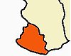
Kanyakumari district is one of the 38 districts of Tamil Nadu state and the southernmost district in mainland India. It stands second in terms of population density among the districts of Tamil Nadu. It is also the richest district in Tamil Nadu in terms of per capita income, and also tops the state in Human Development Index (HDI), literacy, and education. The district's headquarters is Nagercoil.

The Chitharal Jain Monuments and Bhagavati Temple, also known as Chitharal Malai Kovil, Chitaral Cave Temple or Bhagavati Temple, are located near Chitharal village in Kanyakumari district, Tamil Nadu, India. They consist of stone beds with inscriptions, and two monuments – one rock cut Jain temple with outer wall reliefs and one Hindu goddess temple next to it that is a combination of rock-cut and stone that was added during the reign of Vikramaditya Varaguna Pandya. The monuments are from the 9th century CE.
Puzhuthivakkam, commonly known as Ullagaram or Ullagaram–Puzhuthivakkam, is a southern neighbourhood of Chennai in Tamil Nadu, India. Puzhuthivakkam loosely translates to dust neighborhood. The neighbourhood is part of the Greater Chennai Corporation, following Chennai's expansion into Kanchipuram district. Puzhuthivakkam is located between the neighborhoods of Madipakkam, Adambakkam, Velachery, Pallikaranai, and Nanganallur. Puzhuthivakkam was initially developed in the late 1960s and early 1970s. Upon completion of the MRTS extension line, the neighborhood will be served by Puzhuthivakkam railway station. As of 2011, the town had a population of 53,322.
Tiruchengode is a selection grade municipality located in western part of southern Indian state of Tamil Nadu. It is famous for the ancient hilltop Ardhanareeswarar Temple, dedicated to the unique combined male-female form of Lord Shiva and Goddess Parvathi. This important place of pilgrimage is mentioned in the Tamil work Silapathikaram as 'Nedulkundru' and is celebrated in the hymns of Saivite saints. The equally famous Chenkottu Velavar Temple, dedicated to Lord Murugan, is situated on the same hill. As of 2011, the town had a population of 95,335. As per 2011 population, Tiruchengode is the largest city in Namakkal district. It is also famous for rig business.
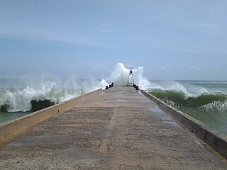
Colachel is a coastal town in the far south of India, located in the Kanyakumari district of Tamil Nadu. It is a natural harbor on the Malabar coast, located 20 km north-west of Kanyakumari, the southernmost tip of India. As of 2011 the municipality had a population of 23,227 and a metropolitan population of 47,007.

Kulithalai is a municipality in Karur district & Sub-urb of Tiruchirapalli City in the Indian state of Tamil Nadu. The recorded history of Kulithalai is known from Cheras, followed by medieval Chola period of the 9th century and has been ruled, at different times, by the Medieval Cholas, Later Cholas, Later Pandyas, Vijayanagar Empire and the British.
Madhavaram is a neighbourhood of Chennai, Tamil Nadu, India. Located in the northern part of Chennai, it is also a taluk in Chennai District and a zone in Greater Chennai Corporation. It is located in between Perambur and Kodungaiyur. As of 2011, the neighbourhood had a population of 119,105. The Chennai district was expanded on 16 August 2018 by transferring Madhavaram taluk from Tiruvallur district to Chennai district.

Madurantakam is the southernmost suburb of Chennai city and a municipality in Chengalpattu district in the Indian state of Tamil Nadu. The town is known for the artificial and second largest lake in Tamil Nadu, the Madurantakam lake. It is said to have been built by the Chola King Uttama Chola, also called as Maduranthaka, during his reign. It is also home to the Eri-Katha Ramar Temple. As of 2011, the town had a population of 30,796.
Mettupalayam is a municipality town and taluk headquarters of Mettupalayam Taluk in the Coimbatore district of the Indian state of Tamil Nadu, a suburb of Coimbatore. It is the third largest town in the Coimbatore district after Coimbatore and Pollachi. It's located to the North of the Coimbatore city on the way to Ooty in the foothills of Nilgiri hills. As of 2011, the town had a population of 66,595. Mettupalayam railway station is the starting point of Nilgiri Mountain Railway and it operates the only rack railway in India connecting Ooty and Mettupalayam.

Thiruparankundram, also spelled Tirupparankundram or Tiruparangundram, is a neighbourhood in Madurai city in Tamil Nadu, India. It is about 7 kilometres (4.3 mi) from Periyar Bus Terminus, the centre of the city and constitutes the southwest part of the Madurai city. The town's landmark and fame is the huge monolithic rock hill that towers to a height of 1,048 feet (319 m) and has a circumference of over 2 miles (3.2 km). It is a home to many ancient and historic monuments including Jain caves, some protected as India's national monuments.

Thuraiyur is a town and a municipality in the Tiruchirappalli district in the Indian state of Tamil Nadu. It was upgraded to a III Grade Municipality from Town Panchayat on 17 January 1970, and to a II Grade Municipality in May 1998. It was upgraded to Selection Grade Municipality in the year 2008. It is also a taluka. It is located 310 km away from Chennai.

Sengottai is a town in the Tenkasi district, of Tamil Nadu, India. It is the gateway to southern Tamil Nadu and Kerala. Spread over an area of 2.68 km2 with a population of over 26,823, the economy of the town and Sengottai Taluk revolves around the cultivation of rice,coconut,Mango,clove and pepper. Sengottai is well known in Tamil Nadu as a major market of Dosa kal. This town has lot of Black smith shops.
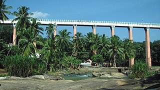
Mathur Aqueduct is an aqueduct in Kalkulam taluk of Kanniyakumari district of Indian state of Tamil Nadu. It is built over the Pahrali River and takes its name from Mathoor, a hamlet near the aqueduct, which is about 3 km from Thiruvattar town and about 60 km from Kanniyakumari.
Madichel is a village in Vilavancode taluk, Kanniyakumari district, Tamil Nadu, India. The village is near Kuzhithurai, a historical seaport where merchants came from across the Arabian sea in ancient times.