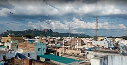
Pernambut[1] is a town and municipality located in the Vellore district of the Indian state of Tamil Nadu. It serves as a regional headquarters and is known for its leather tanning industry, earning it the nickname "Leather City" of Tamil Nadu.
Pernambut is a multicultural town where people of various religions live harmoniously.[2]
Islam: Major Muslim places of worship in Pernambut include Chowk Masjid, Jamiya Masjid, Nawab Daryakhan Masjid, Park Masjid, Road Masjid-e-Ahle Hadees, New Masjid-e-Ahle Hadees, Small Masjid-e-Ahle Hadees, Masjid-e-Istiqamath, Ahle Hadees Forquan Masjid, Masjid-e-Hassaniya Ahle Hadees, Ahle Hadees Jamiya Masjid, Masjid-e-Shekul Hadees, Masjid Umar, Masjid-e-Fazal, and several others.[citation needed]
Hinduism: Prominent Hindu temples in Pernambut include Gangai Amman Kovil, Sivan Kovil, Anjaneyar Kovil, Krishnar Kovil, Vinayagar Kovil, and Venkatesa Perumal Temple (with Sri Devi and Bhu Devi).[citation needed]
Christianity: Notable Christian churches in the town include St. Paul’s Lutheran Church (IELC) and the Church of God (COG).[citation needed]
Demographics
Religious census
Religion
Percent (%)
Muslim
61.56%
Hindu
36.44%
Christian
1.72%
Jain
0.10%
Other
0.15%
According to the 2011 Census of India, Pernampattu had a population of 51,271, with a sex ratio of 1,028 females for every 1,000 males — much above the national average of 929.[3]
A total of 6,866 were under the age of six, consisting of 3,452 males and 3,414 females. Scheduled Castes and Scheduled Tribes accounted for 23.57% and 0.02% of the population respectively.
The average literacy rate of the town was 68.94%, compared to the national average of 72.99%.[3] The town had a total of 10,450 households.
There were 16,523 workers in total — 62 cultivators, 103 main agricultural labourers, 1,602 in household industries, 12,838 in other occupations, and 1,918 marginal workers (including 30 marginal cultivators, 18 marginal agricultural labourers, 158 in household industries, and 1,712 in other sectors).[4]
Pernambut is a multicultural town with people from all major religions. According to the 2011 Census, the population comprised 61.56% Muslims, 36.44% Hindus, 1.72% Christians, 0.02% Sikhs, 0.0% Buddhists, 0.10% Jains, and 0.15% belonging to other religions. A very small percentage of the population did not specify their religion.[5]
The economy is dependent on the leather industries, glue factories, as well as beedi factories where many locals work.[9] The town houses leather tanning and manufacturing facilities and is a leading cluster for the export of finished leather and leather-related products.[citation needed]
Pernambut is also known for its Unani medicine. Ramadan and Eid al-Adha festivals are celebrated by Muslims, Diwali and Pongal by Hindus, and Easter and Christmas by Christians.[citation needed]
Paddy, bananas, coconuts, groundnuts, corn, soya, and vegetables are cultivated here.[citation needed]
Transport
The town has transport facilities in all directions, with major National Highways passing through Pernambut. NH 75 connects Mangalore, Bangalore, and Vellore. State Highways, major district roads, and village roads provide access to nearby important towns such as Ambur, Vaniyambadi, Gudiyatham, Pallikonda, and Vellore. It also connects to the metro cities of Chennai and Bangalore.
1 2 "Census Info 2011 Final Population Totals". Office of The Registrar General and Census Commissioner, Ministry of Home Affairs, Government of India. 2013. Retrieved 26 January 2014.
This page is based on this Wikipedia article Text is available under the CC BY-SA 4.0 license; additional terms may apply. Images, videos and audio are available under their respective licenses.