Thiruthuraipoondi

Last updated

Thiruthuraipoondi
Tirutturaippundi
Town
Piravimarundeesar temple.jpg
Piravi Marundeeswarar Temple
Nickname: 
TTP
India Tamil Nadu location map.svg
Red pog.svg
Thiruthuraipoondi
Location in Tamil Nadu, India
Coordinates: 10°32′N79°39′E / 10.53°N 79.65°E / 10.53; 79.65
CountryFlag of India.svg India
State..Tamil Nadu Flag(INDIA).png Tamil Nadu
District Tiruvarur
Taluk Thiruthuraipoondi
Zone Cauvery Delta
Region Chola Nadu
Government
  TypeMunicipality
  BodyThiruthuraipoondi Municipality
  CommissionerS. Nagarajan
Area
  Total11.94 km2 (4.61 sq mi)
Elevation
4 m (13 ft)
Population
 (2011)
  Total24,404
  Density2,000/km2 (5,300/sq mi)
Languages
  Official Tamil
Time zone UTC+5:30 (IST)
PIN
614713
Telephone code04369
Vehicle registration TN 50R
Literacy88.63%
Lok Sabha constituency Nagapattinam
Vidhan Sabha constituency Thiruthuraipoondi
Avg. annual temperature28.3 °C (82.9 °F)
Avg. annual rainfall930.11 millimetres (36.619 in)
Website thiruthuraipoondi.net

Thiruthuraipoondi is a municipality in Tiruvarur district in the Indian state of Tamil Nadu. Thiruthuraipoondi is an agricultural town located south of Thiruvarur district. The town is located at a distance of 28 km (17 mi) from the district headquarters Thiruvarur.

Contents

Tirutturaipundi is a taluk in Tanjore District (Madras Presidency), after independence, it was a part of Thanjavur district till 1991. It subsequently became a part of the newly formed Tiruvarur district on January 1, 1997.

The Mulli river passes through the town. It is 1,260 square kilometres (490 sq mi) and includes more than 25 villages. Most of the people work in agriculture.

Thiruthuraipoondi is 330 km (210 mi) south of Chennai, 40 km (25 mi) south of Nagapattinam and 65 km (40 mi) east of Thanjavur. As of 2011, the town had a population of 24,404.

History

The town was ruled by various dynasties including the Early Cholas, Kalabhras, Pallavas, Medieval Cholas, Later Cholas; and later by Pandyas, Vijayanagara Empire, Delhi Sultanate, Thanjavur Nayaks, Thanjavur Marathas and the British Empire.

Geography

Thiruthuraipoondi or Thiruthuraipundi (a.k.a. TTP) is an agricultural town located south of District Thiruvarur.

Satellite pictures and carbon dating of some ancient beaches between Thiruthuraipoondi and Kodiyakarai show the Thiruthuraipoondi beach dates back 6,000 years and the Kodiyakarai beach 1,100 years. In other words, the sea was near Thiruthuraipoondi 6,000 years ago and reached Kodiyakarai around 1,100 years ago.[ citation needed ]

Tiruturaipundi is located at 10°32′N79°39′E / 10.53°N 79.65°E / 10.53; 79.65 . [1] It has an average elevation of 4 m (13 ft). Thiruthuraipoondi is located at center of many towns like Mannargudi, Thiruvarur, Muthupet, Vedaranyam, Velankanni, Nagapattinam. Thiruthuraipoondi is located at Thiruvarur district.

Economy

Agriculture is the main occupation for people living in Thiruthuraipoondi and surrounding areas.[ citation needed ] Rice and dhal items grow here. The short-term Kuruvai and long-term Samba rice crops are cultivated depending on the water sources. Thiruthuraipoondi Cooperative Urban Bank was established in 1911, and is the oldest bank in the city .[ citation needed ] Several major banks have branches in Thiruthuraipoondi.

Market

Thiruthuraipoondi Municipal Market is one of the important commercial centre, which supports the daily needs of population residing in and the surrounding rural areas & the town. The Municipality market is located in the central area accommodates 45 shops. The commercial activities are concentrated along TVR Road, Mannai salai, R.S. Road, D.M.C. Road, Bazar Street. Thiruthuraipoondi Municipal Market is one of the important commercial centres and generates revenue . At present, Municipal market is located in the central area near old bus stand area. The existing market needs to be retrofitted with additional facilities. Thiruthuraipoondi Municipality maintained one Fish market at Chetty street, Thiruthuraipoondi.

Demographics

Religious census
ReligionPercent(%)
Hindu
90.41%
Muslim
6.36%
Christian
3.09%
Sikh
0.04%
Other
0.09%
No religion
0.01%

According to 2011 census, Thiruthuraipoondi had a population of 24,404 with a sex-ratio of 1,036 females for every 1,000 males, much above the national average of 929. [2] A total of 2,324 were under the age of six, constituting 1,180 males and 1,144 females. Scheduled Castes and Scheduled Tribes accounted for 29.7% and 1.84% of the population respectively. The average literacy of the town was 80.19%, compared to the national average of 72.99%. [2] The town had a total of : 6263 households. There were a total of 9,378 workers, comprising 607 cultivators, 885 main agricultural labourers, 92 in house hold industries, 4,833 other workers, 2,961 marginal workers, 57 marginal cultivators, 2,076 marginal agricultural labourers, 41 marginal workers in household industries and 787 other marginal workers. [3] As per the religious census of 2011, Thiruthuraipoondi had 90.41% Hindus, 6.36% Muslims, 3.09% Christians, 0.04% Sikhs, 0.09% following other religions and 0.01% following no religion or did not indicate any religious preference. [4]

Culture

Gajasamharamurti panel, Tirutturaippundi South-Indian Images of Gods and Goddesses-Page No.131-Gajahamurti Tirutturaippundi.jpg
Gajasamharamurti panel, Tirutturaippundi

Thiruthuraipoondi has many Hindu temples, prominent one being the Chola-era, Bhava Oushadeeswara or Piravi Marundeeswarar Temple dedicated to Lord Shiva. Lord is worshipped as Gajasamharamurti . [5] [6]

Idol theft

Nataraja (Freer Gallery) Bronze Shiva Nataraja, Tamil Nadu State, Chola Dynasty, c. 990 AD (10433443515).jpg
Nataraja (Freer Gallery)

The idol of Nataraja belonging to the temple is believed to be stolen and smuggled abroad sometime after 1957, when it was last seen during a record-keeping exercise by the French Institute of Pondicherry. The Idol Wing of the Tamil Nadu Criminal Investigation Department (IW-CID) has traced it to the Freer Gallery of Art in the United States. [7]

Politics

Since 1971, Tiruthuraipundi assembly constituency has been consistently voting for Communist Party of India. This is one of few constituents in Tamil Nadu, that is a bastion for communist parties in Tamil Nadu. G. shri Palaniswamy, of CPI, has won this constituent, four straight elections, from 1989 to 2001. He won this constituent in 1991, which made it one of handful of constituents, that was won by a party other than ADMK/Congress, that year.[ citation needed ]

Tiruthuraipundi comes under the Nagapattinam (Lok Sabha constituency). [8] The current Member of Parliament from the constituency is M. Selvarasu from the CPI. [9] From 1957, the Nagapattinam parliament seat was held by the Indian National Congress for 4 times during 1957–1961, [10] 1962–67, [11] 1991–96, [12] and 1996–98 [13] elections. CPI won the seat for 5 times during 1971–77, [14] 1977–80, [15] 1989–91 [16] elections. DMK won 4 times during 1980–84, [17] 1999–2004, [18] 2004–09 [19] and 2011 elections. ADMK won the seat once during 1984–89. [20]

Municipality

Thiruthuraipoondi is a Municipality in district of Thiruvarur, Tamil Nadu and Thiruthuraipoondi is the headquarters of Thiruthuraipoondi taluk, Thiruthuraipondi Municipality was upgraded from selection grade Town Panchayat to Third grade Municipality 1992 and upgraded as Second Grade Municipality in 1996.As of 2011, the municipality covered an area of 11.94 km2 (4.61 sq mi) and had a population of 120,336. Thiruthuraipoondi comes under the Thiruthuraipoondi assembly constituency which elects a member to the Tamil Nadu Legislative Assembly once every five years and it is a part of the Nagapattinam constituency which elects its member of Parliament (MP) once in five years. The Thiruthuraipoondi Municipality is divided into 24 wards for which elections are held every 5 years. The Thiruthuraipoondi Municipality has population of 24,404 of which 11,985 are males while 12,419 are females as per report released by Census India 2011

The functions of the municipality are devolved into six departments: general administration/personnel, engineering, revenue, health, town planning and information technology (IT). All these departments are under the control of a municipal commissioner.

Roadways and railways are the major mode of transportation to the town. The nearest seaport, Nagapattinam Port, is located 43 km (27 mi) from Thiruthuraipoondi, while the nearest airport, Tiruchirappalli International Airport, is located 124 km (77 mi) from the town.

Utility services

Electricity

Electricity supply to Thiruthuraipoondi is regulated and distributed by the Tamil Nadu Electricity Board (TNEB). The town and its suburbs forms the Trichy Electricity Distribution Circle. Thiruthuraipoondi TNEB office located at Anna Nagar, Thruthuraipoondi and Thiruthuraipoondi Sub-power station located at Pallankoil, Tiruthuraipoondi

Water

water supply to the town was provided from Kollidam River at Thiruvaikavur. Water supply is provided by the municipality of Thiruthuraipoondi; there are 9 over Head Tanks with a capacity of 17.15 lakhs litres in municipality.

Solid waste

Solid waste is collected by Thiruthuraipoondi Municipality every day by door-to-door collection. Subsequently, the source segregation and dumping is carried out by the sanitary department of the municipality.the Compost Yard(4.50 Acres) is located at Vedhai road.

Medical and emergency

There are two government hospitals, One maternity centre and ten private hospitals and private clinics in Thiruthuraipoondi and municipal health care centre at Ramamada street.

Law and order

Town Police Station of Thiruthuraipoondi, located at Mannargudi Road. All Women Police Station of Thiruthuraipoondi, located at Mannargudi Road. Deputy Superintendent of Police Camp Office, located at opposite of Police Station. Combined District Municipal Court Building located at D.M.C road.

Paddy festival

Nel Thiruvizha or Paddy Festival is one of the biggest seed exchange programmes in the whole country, organised every year by the Save our Rice Campaign and the local host organisation – CREATE – at Thiruthuraipoondi. It was Nel Jayaraman who initiated this festival in 2007, when he, as the state coordinator of the campaign, had collected 15 indigenous seeds along with his mentor and guru Dr Nammalvar. In 12 years, he and his followers, enthusiastic organic farmers and seed savers, have collected about 174 varieties, most of them on the verge of extinction, from various regions in Tamil Nadu.

Transport

Piravimarundeesar Temple at Thiruthuraipoondi Thiruthuraipoondi temple.jpg
Piravimarundeesar Temple at Thiruthuraipoondi

Thiruthuraipoondi is well connected by road and rail with neighbouring towns.

Road

NH-32 (ECR) connecting Chennai–Nagapattinam–Velankanni–Thiruthuraipoondi–Muthupet–Ramanathapuram–Thoothukudi–Kanyakumari, SH-23 Thiruthuraipoondi to Mayiladuthurai via Thiruvarur, SH-63 connecting Thanjavur–Vedharanyam and Kodiyakarai,

Buses are available to lot of major towns like Thiruvarur, Mannargudi, Muthupet, Pattukkottai, Velankanni, Nagapattinam, Vedharanyam, Kodiyakarai, Kumbakonam, Mayiladuthurai, Thanjavur, Trichy. Also good number of buses plying to long-distance places like Coimbatore, Chennai, Madurai, Karur, Namakkal, Salem, Tirupur, Palani, Dindigul, Puducherry, Chidambaram, Kanchipuram, Viluppuram, Thiruchendur, Thoothukudi, Ramanathapuram, Ervadi, Sivagangai, Karaikudi, Thisayanvilai, Rameswaram, Mudukulathur, Sayalgudi and Bengaluru, Kulasekarapattinam, Tirunelveli Nagercoil Trivandrum as well. TNSTC Ticket reservation counter in New busstand, State Express Transport Corporation (Tamil Nadu) (SETC) and several private bus operators ply to cities like Chennai, Puthucherry, Salem, Hosur, Bengaluru, Coimbatore, Ramanathapuram, Thoothukudi, Tirunelveli, Nagercoil, Soon SETC and TNSTC planned to operate services to Tirupathi, Vellore, Erode and Coimbatore.

Rail

Tiruturaipundi Junction railway station TTP Junction.jpg
Tiruturaipundi Junction railway station

Tiruturaipundi Junction railway station serving the town of Thiruthuraipoondi, Train service between Thiruvarur Junction and Karaikkudi Junction via Thiruthuraipoondi route and Tiruturaipundi Junction to Vedharanyam, Agasthiyampalli railway station, and the New railway line works between Nagapattinam JunctionVelankanni–Thirukuvalai–Tiruturaipundi Junction.

Education

There are four government high schools out of a total of 12 schools in the town. The Government Higher Secondary School (formerly Board High School), founded by the British government in 1936.This is one of the largest and oldest government school in Thiruvarur district, the Bharathidasan University Model College located at Velur, Thiruthuraipoondi, one teacher training institute at Paruthichery, Thiruthuraipoondi, one Industrial training institutes (ITI) and polytechnic college at Korukkai, Thiruthuraipoondi.

Villages

Footnotes

  1. Falling Rain Genomics, Inc – Tiruturaipundi
  2. 1 2 "Census Info 2011 Final population totals". Office of The Registrar General and Census Commissioner, Ministry of Home Affairs, Government of India. 2013. Retrieved 26 January 2014.
  3. "Census Info 2011 Final population totals – Thiruthuraipoondi". Office of The Registrar General and Census Commissioner, Ministry of Home Affairs, Government of India. 2013. Retrieved 26 January 2014.
  4. "Population By Religious Community - Tamil Nadu" (XLS). Office of The Registrar General and Census Commissioner, Ministry of Home Affairs, Government of India. 2011. Retrieved 13 September 2015.
  5. "Sri Piravi Marundeeswarar temple". Dinamalar. Retrieved 8 August 2023.
  6. "Piravi Marundeeswarar, Thiruthuraipoondi". Million Gods. Retrieved 8 August 2023.
  7. "Shiva Nataraja". Freer Gallery of Art and Arthur M. Sackler Gallery. c. 990. Retrieved 8 August 2023. ... In the spring of 2023, the museum discovered that the sculpture was photographed in the Shiva Temple of Sri Bhava Aushadesvara, in Tirutturaiippundi taluk, Thanjavur district of Tamil Nadu, India, in 1957; the original photograph is at the photo archive jointly run by the École Française d'Extrême Orient(EFEO)and the French Institute of Pondicherry (IFP). It is unclear when the sculpture left the Tamil Nadu temple. ...
  8. The Hindu& 31 March 2009.
  9. "General Election 2019 – Election Commission of India". results.eci.gov.in. Archived from the original on 22 June 2019. Retrieved 23 May 2019.
  10. Key highlights of the general elections 1957 to the Second Lok Sabha.
  11. Key highlights of the general elections 1962 to the Third Lok Sabha.
  12. Key highlights of the general elections 1991 to the Tenth Lok Sabha.
  13. Key highlights of the general elections 1996 to the Eleventh Lok Sabha.
  14. Key highlights of the general elections 1971 to the Fifth Lok Sabha.
  15. Key highlights of the general elections 1977 to the Sixth Lok Sabha.
  16. Key highlights of the general elections 1998 to the Twelfth Lok Sabha.
  17. Key highlights of the general elections 1980 to the Seventh Lok Sabha.
  18. Key highlights of the general elections 1999 to the Thirteenth Lok Sabha.
  19. Key highlights of the general elections 2004 to the Fourteenth Lok Sabha.
  20. Key highlights of the general elections 1984 to the Eighth Lok Sabha.

Related Research Articles

<span class="mw-page-title-main">Thanjavur</span> Historical city in Tamil Nadu, India

Thanjavur, also known as Thanjai, previously known as Tanjore, is a city in the Indian state of Tamil Nadu. It is the 11th biggest city in Tamil Nadu. Thanjavur is an important center of southern Indian religion, art, and architecture. Most of the Great Living Chola Temples, which are UNESCO World Heritage Monuments, are located in and around Thanjavur. The foremost among these, the Brihadeeswara Temple, built by the Chola emperor Rajaraja I, is located in the centre of the city. This temple has one of the largest bull statue in India carved out of a single granite rock called Nandi. Thanjavur is also home to Tanjore painting, a painting style unique to the region. Thanjavur is the headquarters of the Thanjavur District. The city is an important agricultural centre located in the Kaveri Delta and is known as the Rice bowl of Tamil Nadu. Thanjavur is administered by a municipal corporation covering an area of 36.31 km2 (14.02 sq mi) and had a population of 222,943. Roadways are the major means of transportation, while the city also has rail connectivity. The nearest airport is Tiruchirapalli International Airport, located 59.6 km (37.0 mi) away from the city. The nearest seaport is Karaikal, which is 94 km (58 mi) away from Thanjavur. The city first rose to prominence during the reign of the Cholas when it served as the capital of the empire. After the fall of the Cholas, the city was ruled by various dynasties such as the Mutharaiyar dynasty, the Pandyas, the Vijayanagar Empire, the Madurai Nayaks, the Thanjavur Nayaks, the Thanjavur Marathas and the British Empire. It has been a part of independent India since 1947.

<span class="mw-page-title-main">Nagapattinam</span> Town in Tamil Nadu

Nagapattinam is a town in the Indian state of Tamil Nadu and the administrative headquarters of Nagapattinam district. The town came to prominence during the period of Medieval Cholas and served as their important port for commerce and east-bound naval expeditions. The Chudamani Vihara in Nagapattinam constructed by the Srivijayan king Sri Mara Vijayattungavarman of the Sailendra dynasty with the help of Rajaraja Chola I was an important Buddhist structure in those times. Nagapattinam was settled by the Portuguese and, later, the Dutch under whom it served as the capital of Dutch Coromandel from 1660 to 1781. In November 1781, the town was conquered by the British East India Company. It served as the capital of Tanjore district from 1799 to 1845 under Madras Presidency of the British. It continued to be a part of Thanjavur district in Independent India. In 1991, it was made the headquarters of the newly created Nagapattinam District. Nagapattinam is administered by a Special grade municipality covering an area of 17.92 km2 (6.92 sq mi) and had a population of 102,905 as of 2011.

<span class="mw-page-title-main">Mannargudi</span> Town in Tamil Nadu, India

Mannargudi is a town in Thiruvarur district in the Indian state of Tamil Nadu. It is the headquarters of the Mannargudi taluk. The town is located at a distance of 28 km (17 mi) from the district headquarters Thiruvarur, 36 km from Kumbakonam, 40 km from Thanjavur and 310 km (190 mi) from the state capital Chennai. Mannargudi is known for the Rajagopalaswamy temple, a prominent Vaishnavite shrine.

<span class="mw-page-title-main">Pudukkottai</span> Municipality and administrative head quarters of Pudukkottai district

Pudukkottai is the administrative headquarters of Pudukkottai District in the Indian state of Tamil Nadu. It is a town located on the banks of the Vellar River. It has been ruled, at different times, by the mutharaiyar dynasty, Cholas, Early Pandyas, Thondaimans, and the British. It is situated about 395 kilometres (245 mi) southwest of the state capital Chennai and about 55 kilometres (34 mi) southeast of Tiruchirappalli. Tamil Nadu's first woman Asian Games competitor, Santhi Soundarajan, is from Pudukkottai.

<span class="mw-page-title-main">Thiruvarur</span> Town in Tamil Nadu, India

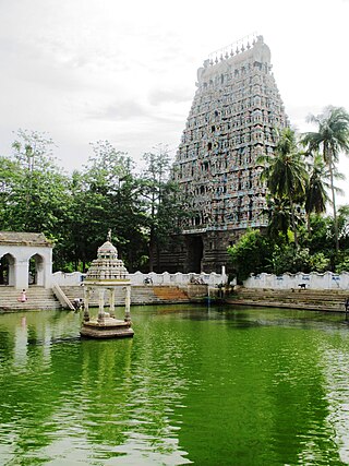
Thiruvarur also spelt as Tiruvarur is a town and municipality in the Indian state of Tamil Nadu. It is the administrative headquarters of Thiruvarur district and Thiruvarur taluk. The temple chariot of the Thyagaraja temple, weighing 360 tonnes (790,000 lb) and measuring 96 feet (29 m) tall is the largest temple chariot in India. Thiruvarur is the birthplace of Tyagaraja, Muthuswami Dikshitar and Syama Sastri, popularly known as the Trinity of Carnatic music of the 18th century CE. Thiruvarur Thiyagarajaa Swaamy temple is older than Tanjore big temple.

<span class="mw-page-title-main">Nagapattinam district</span> District of Tamil Nadu in India

Nagapattinam district is one of the 38 districts of Tamil Nadu state in southern India. Nagapattinam district was carved out by bifurcating the erstwhile composite Thanjavur district on 19 October 1991. The town of Nagapattinam is the district headquarters.

<span class="mw-page-title-main">Muthupet</span> Town in Tamil Nadu, India

Muthupet is a panchayat town in the Thiruvarur district in the Indian state of Tamil Nadu. It is also known as Pearlpet. Muthupet comes under the Thiruthuraipoondi assembly constituency which elects a member to the Tamil Nadu Legislative Assembly every five years. The current member of the legislative assembly (MLA) is Marimuthu of the Communist Party of India, a part of the Nagapattinam, which elects its member of parliament (MP) every five years. The Muthupet city in-town panchayat was constituted in 1962. The town comes under the administrative territory of the Thiruvarur District. It extends over an area of 11.80 km2.

<span class="mw-page-title-main">Needamangalam</span> Town Panchayat in Tamil Nadu, India

Needamangalam (Nidamangalam) formerly Yamunambalpuram, is a town panchayat in Thiruvarur district in the Cauvery Delta of Indian state of Tamil Nadu. Needamangalam was originally part of the composite Tanjore Dist during British Raj until 1997 AD. In the 18th and 19th century, it was also called Yamunambalpuram. Needamangalam is the headquarters of the Needamangalam Taluk. The town is located 20 km east of Thanjavur, 80 km east of Tiruchirappalli and 318 km south of Chennai. Needamangalam is a junction for two busy highways, (i) National Highway 67 is a National Highway in Southern Indian states of Tamil Nadu and Karnataka that runs from Nagapattinam, a sea-side town in Tamil Nadu to Gundlupet, Karnataka (ii) State Highway SH-66 connecting Kumbakonam with Adirampattinam via Mannargudi in Cauvery Delta.

<span class="mw-page-title-main">Pattukkottai</span> City in Tamil Nadu, India

Pattukkottai is a major town in Thanjavur district in the Indian state of Tamil Nadu and also important town in Delta districts and Commercial town of Thanjavur, Thiruvarur and Pudukkottai district Coastal areas. The town came to prominence throughout Southern India after the construction of the fort by Vanaji Pandithar, a feudatory of the Thanjavur Maratha ruler Shahuji I in 1686–87. The recorded history of Pattukkottai is known from the 17th century and has been ruled, at different times, by the Thanjavur Marathas and the British. It is the headquarters of the Pattukkottai taluk of Thanjavur district and is one of the two municipalities in the district.

<span class="mw-page-title-main">Valangaiman</span> Town panchayat in Tamil Nadu, India

Valangaiman is a town Panchayat in the Valangaiman taluk of Thiruvarur district in the Indian state of Tamil Nadu. It is the headquarters of Valangaiman Taluk.

<span class="mw-page-title-main">Vedaranyam</span> Town in Tamil Nadu, India

Vedaranyam is a town in Nagapattinam district in the Indian state of Tamil Nadu. The town is named after the presiding deity of the Vedaranyeswarar Temple. The recorded history of Vedaranyam is known from medieval Chola period of the 9th century and has been ruled, at different times, by the Medieval Cholas, Later Cholas, Later Pandyas, Vijayanagar Empire and the British. During India's independence struggle, C. Rajagopalachari, who would later become independent India's first Governor-General, launched a salt march in Vedaranyam parallel to the Dandi March launched by Gandhi in 1930 to protest against the sales tax levied on salt extraction.

<span class="mw-page-title-main">East Coast Road</span> Road in Tamil Nadu, India

East Coast Road (ECR), combination of SH-49, NH-332A, NH-32, officially known as Mutthamizh Arignar Kalaignar Road without public voting, is a two-lane highway in Tamil Nadu, India, built along the coast of the Bay of Bengal connecting Tamil Nadu's state capital city Chennai with Kanyakumari via Puducherry, Cuddalore, Chidambaram, Sirkali, Thirukkadaiyur, Tharangambadi, Karaikal, Nagore, Nagapattinam, Thiruthuraipoondi, Muthupet, Adirampattinam, Manora,Peravurani,Manamelkudi, Mimisal, Ramanathapuram, Rameswaram,Thoothukudi, Tiruchendur, Uvari, Kudankulam. The total length of the road is about 777 km between Chennai and Kanyakumari.

<span class="mw-page-title-main">Tiruvarur district</span> District of Tamil Nadu in India

Thiruvarur district is one of the 38 districts in the Tamil Nadu state of India. As of 2011, the district had a population of 1,264,277 with a sex-ratio of 1,017 females for every 1,000 males.

<span class="mw-page-title-main">Nagapattinam Lok Sabha constituency</span> One of the 39 Parliamentary Constituencies in Tamil Nadu, in India.

Nagapattinam is a Lok Sabha constituency in Tamil Nadu. Its Tamil Nadu Parliamentary Constituency number is 29 of 39. The seat is reserved for scheduled castes. The constituency is noted for being an historically communist stronghold, having elected Communist Party of India parliamentary representative seven times.

<span class="mw-page-title-main">Koothanallur</span> Town in Tamil Nadu, India

Koothanallur is a town in Tiruvarur district in the South Indian state of Tamil Nadu. The town is located at a distance of 20 km (12 mi) from the district headquarters Tiruvarur and 350 km (220 mi) from the state capital Chennai. Koothanallur is known for the Big Pallivasal. Sri Ramanatha Swamy Thirukovil, an ancient temple at Tirurameshwaram, is located 7 km (4.3 mi) far to Koothanallur, southerly.

Nachikulam is a village administered by the Udayamarthandapuram Panchayath in Thiruvarur district in the Indian state of Tamil Nadu. It is the main line in the East Coast Road. It is also a part of Muthupet.

<span class="mw-page-title-main">Thiruvarur Junction railway station</span> Railway station in Tamil Nadu

Thiruvarur Junction is a junction railway station serving Thiruvarur town, headquarters of Thiruvarur district in Tamil Nadu in India and a focal point on the branch line connecting trains from Chennai to Nagapattinam–Velankanni–Nagore–Karaikal on one line and Karaikkudi–Sivganga–Manamadurai–Rameswaram on the second line and Tiruchirappalli–Thanjavur–Thiruvarur–Nagapattinam–Karaikal on the third line and Mayiladuthurai–Thiruvarur on the fourth line that branches out of the station.

<span class="mw-page-title-main">K. Gopal (ADMK politician)</span> Indian politician

K. Gopal is an Indian doctor and politician. He obtained a M.B.B.S degree from Thanjavur Medical College. Gopal was a Member of the Legislative Assembly from Nannilam 1991 to 1996. In 2014 he was elected to the Lok Sabha from the Nagapattinam as an Anna Dravida Munnetra Kazhagam candidate in the 2014 election. He won the seat with 46.06% and was elected Member of Parliament for Nagapattinam for 16th Lok Sabha.

<span class="mw-page-title-main">Tiruturaipundi Junction railway station</span> Railway station in Tamil Nadu, India

Tiruturaipundi Junction railway station is a junction railway station serving the town of Thiruthuraipoondi in Tamil Nadu, India. This station was first opened on 02.04.1894 along with mayavaram jn to muthupettai section.15.05.1919 Tiruturaipundi Junction - point Calimere line opened for traffic that day this station become junction.This station Is the only junction situated between thiruvarur -karaikudi section. The station is a part of the Tiruchirapalli railway division of the Southern Railway zone Railway station code: TTP.

Munnavalkottai is a village in the Needamangalam taluk of Thiruvarur district in the Indian state of Tamil Nadu.

References