Kilakarai

Last updated

Kilakarai
Municipality
India Tamil Nadu location map.svg
Red pog.svg
Kilakarai
Location in Tamil Nadu, India
Coordinates: 9°13′53″N78°47′04″E / 9.23135°N 78.7844°E / 9.23135; 78.7844
CountryFlag of India.svg  India
State Tamil Nadu
District Ramanathapuram
Taluka Kilakarai
Government
  TypeSecond Grade Municipality
  BodyMunicipality of kilakarai
Area
  Total2.45 km2 (0.95 sq mi)
  Rank5
Elevation
17 m (56 ft)
Population
 (2016)
  Total38,355
  Rank2
  Density16,000/km2 (41,000/sq mi)
Demonym Kilakaraian
Languages
  Official Tamil
Time zone UTC+5:30 (IST)
PIN
623 517
Telephone code91 4567
Vehicle registration TN 65
Distance from Chennai 558 kilometres (347 mi) S
Distance from Bengaluru 539 kilometres (335 mi) S
Distance from Madurai 132 kilometres (82 mi) E
Distance from Ramanathapuram 18 kilometres (11 mi) S
Distance from Coimbatore 365 kilometres (227 mi) W
Distance from Tuticorin 121 kilometres (75 mi) N
Distance from Tiruchirappalli 229 kilometres (142 mi) S
Climate BSh (Köppen)
Precipitation 909 millimetres (35.8 in)
Avg. summer temperature31 °C (88 °F)
Avg. winter temperature24 °C (75 °F)

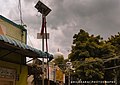
Kilakarai (alternatively spelled Kilakkarai or Keelakarai) is a municipality in Ramanathapuram district in the Indian state of Tamil Nadu. As of 2011, the town had a population of 38,355. Kilakarai is one of the Taluka in Ramanathapuram District.

Contents

History

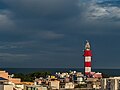
Kilakarai is an eastern coastal town and a port, located in southern Tamil Nadu. It was a flourishing seaport and a gateway to places as far as Madurai until the early 20th century. The famous pearl belt known as the Gulf of Mannar in the Bay of Bengal is dotted with small islands Appa Tivu, Nallathanni Theevu, Shuli Tivu, Uppu Tanni Tivu, Talari Tivu and Musal Tivu. The coastal line of Kilakarai is formed by a series of small bays and coral reefs sheltering the town from the ocean. It was also called as "Quilicare", [1] kirkari, Sembi Nadu, Korkai, Powthira Manicka Pattinam, [2] "Kelikkarai", "Ninathaan mudithaan pattinam", "Seppi Nadu", "lebbat pattan" (pattan mentioned in voyages of Ibn Battuta & map displayed in Ibn Battuta Mall). A strong cultural connection exists between Kayalpatnam, Adirampattinam and Kilakarai.

The prime occupations of the people were pearl, conch, sea trade and transport. [3] The mid-20th century saw a decline in the occupations of the people of Kilakarai, with the advent of surface transport the merchant shipping fleets declined and Kilakarai aka Killikare [4] ceased to be a harbour and port. The cultured pearl industry and dragnet fishing that destroyed the coral reefs choked the once robust pearl trade, or Muthu Salabam. The conch and coral industries declined due to new regulations and restrictions.[ citation needed ]

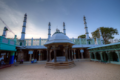
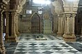
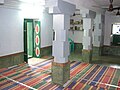
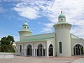
Kilakarai is renowned for its communal harmony. The majority of the population here is Muslim with people of other faith Hindu, Christians living together. The communal harmony that always existed is best exemplified by the famous Rameswaram Ramanathaswamy Temple and Kilakarai Jumma Pallivasal (Vallal Seethakathi is interred here) at Kilakarai, while the architecture is the same the workforce was provided by the erstwhile ruler Sethupathi of Ramnad and most of the materials for both the edifice were supplied by the Kilakarai merchant navies. The town is reminiscent of Spanish Moorish architecture and is located about 60 km south west of the temple town of Rameswaram.

It has the oldest mosque in India known as the Palaiya Kuthba Palli. It has a unique pre-Islamic heritage of more than 1300 years. The Kilakarai Muslims or Kilakarai Moors form 80% of the population of Kilakarai. Ibnu Batutah once said in his travel notes "it's the place where most Arab settlers live and he was surprised to see them living as in Arab land".

The migration of the people after the decline of the marine trade and industry resulted in people exploring the other parts of the globe. Kilakarai has a large expatriate population and a high literacy rate. This has enabled the people of Kilakarai to span the globe and become active merchants in the Middle and Far East, US and European markets.

Hameedia Primary School was started as a Madrasa in the year 1870, and gradually became a Thinnai Palli and became a registered School in 1938 due to the efforts of K.T.M. Hussain Sahib, fondly known as Haajiaar. This school is completing its sesquicentennial year (150th year) in 2020. The Hameedia Primary School Alumni Association - (HPSAA) consists of great stalwarts of Kilakarai including the founders of ETA, Crescent, Sathak Group and more than 100 institutions and business enterprises worldwide.

The 1970s decline of marine trade resulted in people migrating to other countries for business and jobs. Now as per the law of nature the reverse migration is all set to happen. Post-Covid, pandemic and Lockdowns job losses have become the order of the day and disruptions are all set to happen. The Gulf mission to minimise the Indian immigrants, improved and fast-developing job and business opportunities in Tamil Nadu, the native bonding, self-content nature etc. have made many people come back home for good.

To facilitate more people find jobs, career guidance, new business opportunities, the Kilakarai Trade Fair is planned annually to organise business summits, Job Fair, Free Medical Camp, Food Counters, Seminars and Talk shows.Leading Brands, institutions, Business houses are regular participants in these events. This year- 2022 edition is being planned during December 2022 at Kilakarai.

Hameedia High School founded in 1940s beside the old Arabic Madrasa Aroosiya Thaika, was a catalyst to more graduates from Kilakarai. With the arrival of Mohamed Sathak Engineering College [5] and then the Thassim Beevi Abdul Kader College for Women [6] the number of graduates from this traditional town has seen a steady rise.

Kilakarai was constituted as a panchayat in the year 1885. As per G.O. No. 1157LN, date: 3 December 1885. It has since been upgraded as a Special Town Panchayat as per Director of Town Panchayat, Madras as per G.O. No. 1481/82/J5, Dated on 25 January 1982 and then upgraded as per G.O. No. 300 and 301 Dated on 24 August 2004 as a Third Grade Municipality.[ citation needed ]

The Muslim community of Kilakarai is philanthropic in nature, with assistance given to downtrodden sections of society, such as Dalits in Tirunelveli. [7]

Demographics

Religious census
ReligionPercent(%)
Muslims
79.92%
Hindus
17.60%
Christian
1.16%
Sikh
0.01%
Jain
0.00%
Not stated
1.31%

According to 2011 census, Keelakarai had a population of 38,355 with a sex-ratio of 948 females for every 1,000 males, much above the national average of 929. [8] A total of 4,391 were under the age of six, constituting 2,204 males and 2,187 females. Scheduled Castes and Scheduled Tribes accounted for 2.83% and .% of the population respectively. The average literacy of the town was 82.63%, compared to the national average of 72.99%. [8] The town had a total of : 7448 households. There were a total of 12,033 workers, comprising 29 cultivators, 47 main agricultural labourers, 165 in house hold industries, 10,765 other workers, 1,027 marginal workers, 15 marginal cultivators, 18 marginal agricultural labourers, 38 marginal workers in household industries and 956 other marginal workers. [9] As per the religious census of 2011, Keelakarai had 79.92% Muslims, 17.6% Hindus, 1.16% Christians, 0.01% Sikhs, 0.01% Jains, and 1.31% following other religions. [10]

Educational institutions

Schools

Colleges

Notes

  1. Barbosa, Duarte; Dames, Mansel Longworth (1989). The Book of Duarte Barbosa: An Account of the Countries Bordering on the Indian Ocean and Their Inhabitants. ISBN   9788120604513.
  2. "செம்பி நாட்டுக்கதைகள்…… | திண்ணை".
  3. Kunz, G.F.; Stevenson, C.H. (2013). The Book of the Pearl: Its History, Art, Science and Industry. Dover Jewelry and Metalwork. Dover Publications. p. 113. ISBN   978-0-486-14274-6 . Retrieved 14 May 2019.
  4. mohammad suhaib (17 August 2012). "Photo of Kilakarai in an ancient map". Panoramio. Archived from the original on 18 January 2018. Retrieved 6 June 2013.
  5. ":: Mohamed Sathak Engineering College ::". Archived from the original on 11 August 2011. Retrieved 17 August 2011.
  6. "Thassim Beevi Abdul Kader College For Women". Thassim.in. 3 April 2013. Archived from the original on 24 September 2011. Retrieved 6 June 2013.
  7. "Islam's new children - RELIGION News - Issue Date: Jul 31, 1981".
  8. 1 2 "Census Info 2011 Final population totals". Office of The Registrar General and Census Commissioner, Ministry of Home Affairs, Government of India. 2013. Archived from the original on 13 November 2013. Retrieved 26 January 2014.
  9. "Census Info 2011 Final population totals – Keelakarai". Office of The Registrar General and Census Commissioner, Ministry of Home Affairs, Government of India. 2013. Archived from the original on 24 September 2015. Retrieved 26 January 2014.
  10. "Population By Religious Community – Tamil Nadu" (XLS). Office of The Registrar General and Census Commissioner, Ministry of Home Affairs, Government of India. 2011. Archived from the original on 13 September 2015. Retrieved 13 September 2015.

Related Research Articles

Kayalpattinam is a Municipality in Thoothukudi district in the Indian state of Tamil Nadu. As of 2011, the town had a population of 40,588.

Ramanathapuram, also known as Ramnad, is a town and a municipality in Ramanathapuram district in the Indian state of Tamil Nadu. It is the administrative headquarters of Ramanathapuram district and the second largest town in Ramanathapuram district.

<span class="mw-page-title-main">Poonamallee</span> Suburb of Chennai, India

Poonamallee is suburb of Chennai, India under the Chennai Metropolitan Area. It was historically called Pushpagirimangalam, later renamed in Tamil as Poovirundhavalli, and now colloquially called as Poondhamalli. It is a town in the Poonamallee taluk of the Tiruvallur district in the Indian state of Tamil Nadu. The nearest Railway station is at Avadi. It acts as the gateway to the city from its western side. It is a town with rich cultural heritage and also a fast-growing areas in the city. As of 2011, the town had a population of 57,224. There are plans to merge the areas under Poonamallee Municipality with Avadi Municipal Corporation.

Thuckalay or Thakkalai is a town in Kanyakumari district of Tamil Nadu, India. Thuckalay comes under the Padmanabhapuram Municipality, and is the administrative headquarters of Kalkulam Taluk. The Revenue Divisional Office is located in Mettukadai.

Thiruverkadu is a Western suburb of Chennai, Tamil Nadu. It comes under Thiruvallur district administration. It is famous for its Devi Karumariamman Temple. There is also Vedapureeswarar Temple in Thiruverkadu, where Lord Shiva and Goddess Parvathi are seen in their wedding pose inside the sanctum sanctorum. As of 2011, the town had a population of 62,289. It is a town with rich cultural heritage and also a fast-growing areas in the city.

Aranthangi is a town chola Nadu in Pudukkottai district in the state of Tamil Nadu, India. As of 2011, it had a population of 40,814. And this is one of the part in Chettinadu.

Authoor is a panchayat town in Thoothukudi district of the Indian state of Tamil Nadu.

Eruvadi is a town panchayath in Tirunelveli district in the state of Tamil Nadu, India.

Madhavaram is a neighbourhood of Chennai, Tamil Nadu, India. Located in the northern part of Chennai, it is also a taluk in Chennai District and a zone in Greater Chennai Corporation. It is located in between Perambur and Kodungaiyur. As of 2011, the neighbourhood had a population of 119,105. The Chennai district was expanded on 16 August 2018 by transferring Madhavaram taluk from Tiruvallur district to Chennai district.

<span class="mw-page-title-main">Maduranthakam</span> Town in Tamil Nadu, India

Madurantakam is the southernmost suburb of Chennai city and a municipality in Chengalpattu district in the Indian state of Tamil Nadu. The town is known for the artificial and second largest lake in Tamil Nadu, the Maduranthakam lake. It is said to have been built by the Chola King Uttama Chola, also called as Maduranthaka, during his reign. It is also home to the Eri-Katha Ramar Temple. As of 2011, the town had a population of 30,796.

Melvisharam is a town and suburb of Vellore city in the Indian state of Tamil Nadu. It is 7 kilometres from Ranipet, 5 km from historic town of Arcot and 17 km from Vellore city.

Podaturpet is a Town under Pallipattu(Pallipet) Taluk in Thiruvallur district in the Indian state of Tamil Nadu.

<span class="mw-page-title-main">Sholinganallur</span> Neighbourhood in Tamil Nadu, India

Sholinganallur, also spelled Solinganalloor or Sozhinganalloor, is a southern neighbourhood of Chennai, India.

Vallam is a panchayat in the thanjavur taluk of THANJAVUR

<span class="mw-page-title-main">Erwadi</span> Village in Tamil Nadu, India

Erwadi is a village in Ramanathapuram District, Tamil Nadu, a state in South India. It belongs to Kilakarai Taluk and town panchayat. The village is the location of the grave and shrine of Qutbus Sultan Syed Ibrahim Shaheed Badusha, the previous ruler of Medina. Erwadi also belongs to Kadaladi assembly constituency, which is a part of Ramanathapuram. However, after the delimitations in 2009, Erwadi has been joined to the Ramanathapuram assembly constituency. Although a small town, Erwadi is the second largest contributor for the revenue of Ramanthapuram District.

Periyapattinam is a large village located in the eastern part of Ramanathapuram district, Tamil Nadu, India. The inhabitants of this village are primarily Tamil Muslim.

The Moors of Kilakarai are a Tamil Muslim community who form the largest ethnic group in Kilakarai comprising 80% of the towns total population. The Moors of Kilakarai are Marakkars. They are predominantly followers of Islam tracing their ancestry to Arab traders mostly from Arabia and Yemen who settled in Kilakarai some time between 8th-15th century. The Kilakarai Moors lived primarily as coastal trading and agricultural communities, preserving their Islamic cultural heritage while adopting many Southern Asian customs. During the period of Portuguese colonisation of Ceylon, a small population of Sri Lankan Moors settled down in Kilakarai as they suffered widespread persecution.

<span class="mw-page-title-main">Pernambut</span> Headquarters in Tamil Nadu, India

Pernambut is a town and village headquarters also a Municipality in Vellore district in the Indian state of Tamil Nadu. The economy is dependent on leather tanning industry, earning it the nickname Leather Tanning city of Tamil Nadu. Pernambut is a municipality and headquarters of Pernambut Taluk which is an administrative division comprising 52 Revenue villages in the district of Vellore.

Devipattinam is a coastal village of Ramanathapuram district, Tamil Nadu, India.

<span class="mw-page-title-main">Palaiya Jumma Palli</span>

Palaiya Jumma Palli or Meen Kadai Palli is a mosque in Kilakarai, Tamil Nadu, India. Built in 628–630 AD, it is believed to be one of the oldest mosques in the world and along with Cheraman Juma Masjid in Kodungallur, Kerala and Barwada Mosque in Ghogha, Gujarat, the first mosque in India. It has an Islamic heritage of more than 1000 years. It is located in Kilakarai, an ancient port town in the South Indian state of Tamil Nadu known for its Islamic culture. It was built in 628–630 AD and was re-constructed in 1036. The mosque, along with the others in the town, is one of the greatest examples of Dravidian Islam architecture.

References