
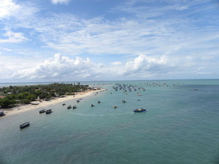
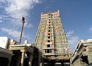
Rameswaram is a municipality in the Ramanathapuram district of the Indian state of Tamil Nadu. It is on Pamban Island separated from mainland India by the Pamban channel and is about 40 kilometres from Mannar Island, Sri Lanka. It is in the Gulf of Mannar, at the tip of the Indian peninsula. Pamban Island, also known as Rameswaram Island, is connected to mainland India by the Pamban Bridge. Rameswaram is the terminus of the railway line from Chennai and Madurai. Together with Varanasi, it is considered to be one of the holiest places in India to Hindus and is part of the Char Dham pilgrimage.

The Vaigai is a river in the Tamil Nadu state of southern India; it passes through the towns of Theni, Madurai and Ramanathapuram. It originates in Varusanadu Hills, the Periyar Plateau of the Western Ghats range, and flows northeast through the Kambam Valley, which lies between the Palani Hills to the north and the Varushanad Hills to the south. The Vattaparai Falls are located on this river. As it rounds the eastern corner of the Varushanad Hills, the river turns southeast, running through the region of Pandya Nadu. Madurai, the largest city in the Pandya Nadu region and its ancient capital, lies on the Vaigai. The river empties into the Palk Bay near Alagankulam, close to Pamban Bridge in Ramanathapuram District.

Tirunelveli district is one of the 38 districts of Tamil Nadu state in India. It is the largest district in terms of area with Tirunelveli as its headquarters. The district was formed on 1 September 1790 by the British East India Company, and comprised the present Tirunelveli and Thoothukudi, Tenkasi and parts of Virudhunagar and Ramanathapuram district. As of 2011, the undivided district had a population of 3,077,233.
Ramanathapuram District, also known as Ramnad District, is one of the 38 districts an administrative districts of Tamil Nadu state in southern India. The old Ramanathapuram District consists of Present day Virudhunagar and Sivagangai districts, it touches the Western ghats and bordered with the state of Kerala and east by Bay of Bengal. It was the largest district on that time. The town of Ramanathapuram is the district headquarters. Ramanthapuram District has an area of 4,123 km2. It is bounded on the north by Sivaganga District, on the northeast by Pudukkottai District, on the east by the Palk Strait, on the south by the Gulf of Mannar, on the west by Thoothukudi District, and on the northwest by Virudhunagar District. The district contains the Pamban Bridge, an east–west chain of low islands and shallow reefs that extend between India and the island nation of Sri Lanka, and separate the Palk Strait from the Gulf of Mannar. The Palk Strait is navigable only by shallow-draft vessels. As of 2011, Ramanathapuram district had a population of 1,353,445 with a sex-ratio of 983 females for every 1,000 males. The district is home to the pilgrimage center of Rameswaram.
Virudhunagar District is a district of Tamil Nadu state in south India. Virudhunagar is the district headquarters of Virudhunagar district. Virudhunagar district was formed by the separation of Old Ramanathapuram District G.O passed on 08,March 1985 & formed in 15,March 1985 into Ramanathapuram District, Sivagangai District and the west part as Virudhunagar District. Virudhunagar District was formerly called Karmavirer Kamarajar District. As of 2011, Virudhunagar district had a population of 1,942,288 with a sex-ratio of 1,007 females for every 1,000 males. Sivakasi is the most populous and largest city in the district.
R. S. Mangalam, also known as Raja Singa Mangalam, is a panchayat town in Ramanathapuram district in the Indian state of Tamil Nadu. It is located 35 Kilometres north from the district headquarters Ramanathapuram.

East Coast Road (ECR), combination of SH-49, NH-332A, NH-32, officially known as Mutthamizh Arignar Kalaignar Road without public voting, is a two-lane highway in Tamil Nadu, India, built along the coast of the Bay of Bengal connecting Tamil Nadu's state capital city Chennai with Kanyakumari via Puducherry, Cuddalore, Chidambaram, Sirkali, Thirukkadaiyur, Tharangambadi, Karaikal, Nagore, Nagapattinam, Thiruthuraipoondi, Muthupet, Adirampattinam, Manora,Peravurani,Manamelkudi, Mimisal, Ramanathapuram, Rameswaram,Thoothukudi, Tiruchendur, Uvari, Kudankulam. The total length of the road is about 777 km between Chennai and Kanyakumari.
Mangalam is a census town in Tiruppur district in the Indian state of Tamil Nadu.
Pudumadam is a village located in the Ramanathapuram district of the Indian state of Tamil Nadu. Situated near the old National Highway 49, which connects Kochi and Dhanushkodi, Pudumadam serves as a vital gateway to the picturesque Pamban Island. The village is approximately 25 kilometers away from the city of Ramanathapuram and 37 kilometers away from the renowned pilgrimage site of Rameswaram. The nearest train station is Uchippuli, located just 4 kilometers away from Pudumadam.
Chittarkottai is a Panchayat in Ramanathapuram district, Tamil Nadu, India. It has consists of seven villages with different faiths of religions people. Most of the people following Hinduism and Islamic Culture. Remaining people following religion of Christianity. The coastline along with 'Bay of Bengal'. People incomes are based on agriculture harvesting and Fishing. The village has the Mohamedia Higher Secondary School and Government High school Palanivalasai in palanivalasai sub village which is the best educational school in Ramanathapuram District. Nearby Syed Ammal arts and science College is there, also one Municipal Maternity home is Located. Some beautiful east coast beaches are available for spending time with family and the village is famous for the Murugan temple Temple near the sea in Mudiveeran Pattinam. There is a famous temple which is visited by many people every year.

The Vaigai Dam is built across the Vaigai River near Andipatti, in the Theni district of Tamil Nadu, southern India. Near the dam, the Government of Tamil Nadu has constructed an Agricultural Research Station for researching the growing of a variety of crops, including rice, sorghum, blackgram, cowpea and cotton.
K. Muthuvel was an Indian politician and former Member of the Legislative Assembly of Tamil Nadu. He was elected to the Tamil Nadu legislative assembly from the Mudukulathur constituency in the 1984 election.
Theriruveli is a village in the Ramanathapuram district of Tamil Nadu state in southern India. It is located near uthrakosamangai and belongs to the Mudukulathur Legislative Constituency. The economy is largely based on agriculture and sheep raising, and remittances from residents who have travelled abroad.
Veeravanoor is a village in Ramanathapuram District in the Indian state of Tamil Nadu.
Rajasingamangalam block is a revenue block in the Ramanathapuram district of Tamil Nadu, India. It has a total of 35 panchayat villages. Tamil nadu’s second largest water resources in here.
Appanur is a village in the Kadaladi Taluk of Ramanathapuram District in Tamil Nadu, India. It is located between Mudukulathur and Sayalgudi, on the State Highway 29 (SH29).
Alagankulam is a village situated on the east coast in the Ramanathapuram taluk and district in India. The village is situated on the banks of the Vaigai River and is about 3 kilometres (1.9 mi) away from the seashore. The village is located 18 kilometres (11 mi) east of Ramanathapuram. The village had a population of 15,473 at the 2011 census.
Kalaiyur is a village in Ramanathapuram in Tamil Nadu, India. It is located 25 km towards north from Ramanathapuram and 9 km away from Paramakkudi. Kalaiyur is known as the Village of Cooks. The village was featured in History TV18's show OMG! Yeh Mera India - Season 2, hosted by Krishna Abhishek.
Parukkaikudi is a village in the Ramanathapuram district of the Indian state of Tamil Nadu.
Manimangalam is a small town located in the Kanchipuram district of Tamil Nadu state in Southern India, famous for its ancient temples and inscriptions documenting the history of the ancient Tamil kings