
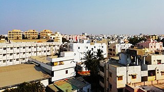
Salem, natively spelt as Selam, is a major city in Salem district, located on the banks of the Thirumanimutharu river in the Indian state of Tamil Nadu surrounded by mountains. Salem is the fifth largest urban agglomeration in the state, exceeded by Chennai, Coimbatore, Madurai, Tiruchirappalli, and Third largest metropolitan region in the state only after to Chennai and Coimbatore metropolitan regions. The city is 124 km2 (48 sq mi) large. Major products of Salem include silver anklets, sago, mangoes, steel, and textiles.

Kanyakumari is a city in Kanyakumari district in the state of Tamil Nadu, India. It is the southernmost tip of the Indian subcontinent and the southernmost city in mainland India, and thus referred to as "The Land's End". The city is situated 90 kilometres (56 mi) south of Thiruvananthapuram city, and about 20 kilometres (12 mi) south of Nagercoil, the headquarters of Kanyakumari district.

Karaikal is a Municipality of the Indian Union Territory of Puducherry. It is the administrative headquarters of the Karaikal District and the second most populated town in the Union Territory after Pondicherry. Located on the Coromandel Coast of Bay of Bengal in South India, it is situated at the center of a coastal enclave surrounded by the state of Tamil Nadu and its Cauvery delta districts.

Coonoor, is a taluk and a municipal town of the Nilgiris district in the Indian state of Tamil Nadu. As of 2011, the town had a population of 45,494. The town sits at the south-east corner of the Nilgiri plateau, and at the head of the Coonoor Ghat, the principal pass connecting the Nilgiris to the plains. It is 363 miles (584 km) by rail from Chennai and 12 miles (19 km) from Ooty. The town is built within the picturesque Jackatalla valley (Jagathala), surrounded by wooded hills.
Kanchipuram district is one of the 38 districts in the state of Tamil Nadu in India. The area comprising the present day Kancheepuram district was earlier a part of Chingleput district. The original Chingleput district was split in 1997 into form the present day Kanchipuram and Tiruvallur districts.

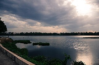
Mettur is an industrial and tourist town located in the Salem district in the state of Tamil Nadu, India. It is best known for the Mettur Dam which is the largest dam in south India.

Tambaram is a city located within the Chennai Metropolitan Area in the Indian State of Tamil Nadu. The city is governed by Tambaram City Municipal Corporation.

Dharmapuri is a city in the north western part of Tamil Nadu, India. It serves as the administrative headquarters of Dharmapuri district which is the first district created in Tamil Nadu after the independence of India by splitting it from then Salem district on 2 October 1965. The city is located 50 km from Krishnagiri, 69 km from Salem, 60 km from Tirupattur, 90 km from Hosur, 117 km from Thiruvannamalai, 126 km from Bangalore and Erode, 181 km from Tiruppur, 200 km from Coimbatore and Tiruchirappalli, 300 km from Madurai and the state capital Chennai. It is located between latitudes N 11 47’ and 12 33’ and longitudes E 77 02’ and 78 40’. It is one of the major leading cultivators and producers of mangoes in the state along with Krishnagiri, and is often referred as Mango Capital of India.
Kavali is a town in Nellore district of Andhra Pradesh of India. It also serves as headquarters of Kavali mandal and Kavali revenue division.It is one of the few cities from Andhra Pradesh which were selected for Atal Mission for Rejuvenation and Urban Transformation (AMRUT) Scheme.

Tiruttani is a historic temple town situated in the Tiruvallur district and serves as a suburb of Chennai within the Chennai Metropolitan Area in the southern Indian state of Tamil Nadu. The town is famous for the Tiruttani Murugan Temple, an ancient Hindu temple dedicated to Kartikeya, also known as Murugan, the Hindu god of war. This temple is one of the Arupadaiveedu, a group of six significant abodes of Murugan. Tiruttani was officially incorporated into the Chennai Metropolitan Area in October 2022, signifying its growing importance and influence within the region..
Koradacheri is a panchayat town in Thiruvarur district in the Indian state of Tamil Nadu. It lies between the rivers Vettar and Vennar flowing at a distance of about 1.5 km.
Patharia is a town and a nagar panchayat in Damoh district in the Indian state of Madhya Pradesh. During World War II, the town served as the training camp for what would become Wingate's Chindits.

The climate of West Bengal is varied, with tropical savannahs in the southern portions of the state, to humid subtropical areas in the north. Temperatures vary widely, and there are five distinct seasons. The area is vulnerable to heavy rainfall, monsoons, and cyclones. There are some mountains in the area which are generally cold all year round.

Chennai is located at 13.04°N 80.17°E on the southeast coast of India and in the northeast corner of Tamil Nadu. It is located on a flat coastal plain known as the Eastern Coastal Plains. The city has an average elevation of 6 metres (20 ft), its highest point being 60 m (200 ft). Chennai is 2,184 kilometres south of Delhi, 1,337 kilometres southeast of Mumbai, and 1,679 kilometers southwest of Kolkata by road.
Adirampattinam is a newly established Municipality in the Pattukottai taluk of the Thanjavur district in the Indian state of Tamil Nadu. It is also short known by Adirai. It is the largest coastal town in the district and fourth largest town in the Thanjavur district.

The climate of Gujarat involves diverse conditions. The plains of Gujarat are very hot and humid in summer and cold and dry in winter. Summer is milder in the hilly regions and the coast. The average daytime temperature during winter is around 29 °C (84 °F) and in nights is around 12 °C (54 °F) with 100 percent sunny days and clear nights. During summers, the daytime temperature is around 49 °C (120 °F) and at night no lower than 30 °C (86 °F). The monsoon season lasts from June to September. Most of Gujarat receives scant rainfall. Southern Gujarat and the hilly regions receive heavy rainfall during the monsoons with high humidity which makes the air feel hotter. There is relief when the monsoon season starts. The day temperatures are lowered to around 35 °C (95 °F) but humidity is very high and nights are around 27 °C (81 °F). Most of the rainfall occurs in this season, and the rain can cause severe Floods. The sun is often occluded during the monsoon season. Though mostly dry, it is desertic in the north-west, and wet in the southern districts due to a heavy monsoon season.
Pamban is a town in the Rameswaram taluk of Ramanathapuram district, Tamil Nadu. It is at the west edge of Pamban Island and is a popular fishing port. The town gives its name to the whole island. Pamban railway station is the first station on the island for pilgrims travelling to Rameswaram.

Bramhapuri is a town and eponymous headquarters of Bramhapuri taluka in Chandrapur district in the state of Maharashtra, India.

The Climate of Tamil Nadu, India is generally tropical and features fairly hot temperatures over the year except during the monsoon seasons. The city of Chennai lies on the thermal equator, which means Chennai and Tamil Nadu does not have that much temperature variation.

Tirupathur or Tirupattur is the headquarters of Tirupathur district in the state of Tamil Nadu in India and is one of the oldest inhabited places in the state, with a history of over 1,600 years. The town is known for an abundance of sandalwood in the surrounding hills. It is located about 89 km (55 mi) from Vellore, 85 km (53 mi) from Hosur, 60 km (37 mi) from Dharmapuri, 50 km (31 mi) from Krishnagiri, 50 km (31 mi) from Thiruvannamalai, 279 km (173 mi) from coimbatore, 210 km (130 mi) from Chennai, and 125 km (78 mi) from Bangalore.
