Pattukkottai

Last updated

Pattukkottai
பட்டுக்கோட்டை
city
Manora renamed.jpg
Manora fort
India Tamil Nadu location map.svg
Red pog.svg
Pattukkottai
Location in Tamil Nadu, India
Coordinates: 10°26′N79°19′E / 10.43°N 79.32°E / 10.43; 79.32
CountryFlag of India.svg  India
State Tamil Nadu
District Thanjavur
Region Chola Nadu
Zone Cauvery Delta
HeadquartersThanjavur
Government
  TypeSelection Grade Municipality
  BodyPattukkottai Municipality
  Municipal Chairperson-
Area
  Total24 km2 (9 sq mi)
Elevation
5 m (16 ft)
Population
 (2011) [1]
  Total73,135
  Density3,000/km2 (7,900/sq mi)
Time zone UTC+5:30 (IST)
PIN
614601, 614602
Telephone code+91 4373
Vehicle registration TN 49
Sex ratio 1003 /
Website 123.63.242.116/Pattukkottai/

Pattukkottai is a major town in Thanjavur district in the Indian state of Tamil Nadu and also important town in Delta districts and Commercial town of Thanjavur, Thiruvarur and Pudukkottai district Coastal areas. The town came to prominence throughout Southern India after the construction of the fort by Vanaji Pandithar, a feudatory of the Thanjavur Maratha ruler Shahuji I in 1686–87. The recorded history of Pattukkottai is known from the 17th century and has been ruled, at different times, by the Thanjavur Marathas and the British. It is the headquarters of the Pattukkottai taluk of Thanjavur district and is one of the two municipalities in the district. [2]

Contents

Pattukkottai comes under the Pattukkottai assembly constituency which elects a member to the Tamil Nadu Legislative Assembly once every five years and it is a part of the Thanjavur (Lok Sabha constituency) which elects its Member of Parliament (MP) once in five years. The town is administered by the Pattukkottai municipality, which covers an area of 21.83 km2 (8.43 sq mi). As of 2011, the town had a population of 73,135. The town is a part of the fertile Cauvery delta region, but the fishery is the major occupation. Roadways and railways are the major mode of transportation to Pattukkottai and the nearest international airport is Tiruchirapalli Airport, located 100 km (62 mi) away from the town, in the city of Tiruchirappalli. 

History

According to an inscription, the fortress of Pattukkottai was constructed by Vanaji Pandithar, a feudatory of the Thanjavur Maratha ruler Shahuji I in 1686–87. [3] Pattukkottai was ruled by the Thanjavur Marathas till 1799 when it was annexed by the British East India Company. It became a part of Tanjore district in 1801.

Having a population of 7,603 in 1901, Pattukkottai experienced a population splurge between 1941 and 1981, when its population quadrupled. Sri Nadiamman temple is the most important Hindu temple in Pattukkottai and is of considerable antiquity. In 2018, cyclone Kaja hit Pattukottai and majority of its farmland and vegetation were lost. It almost took more than year for normalcy to prevail.

Thiru S.D.Somasundaram,R.Venkatraman,V.Nadimuthu pillai and Kalyana Sundram,Alagiri are some of the most famous people born in this soil

Geography

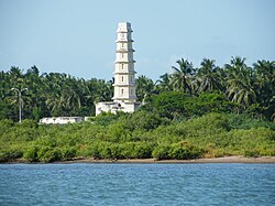
Pattukkottai 10°26′N79°19′E / 10.43°N 79.32°E / 10.43; 79.32 [4] is located along the southeastern coast of India in the East-central region of Tamil Nadu, in the general Kaveri River delta area. Pattukkottai Municipality covers an area of 21.83 km2., and has an average elevation of 5  meters (16  feet). Pattukkottai is 48 km from the city of Thanjavur. The coast of the Bay of Bengal is just 12  km away, with Manora fort 15  km away from this town.

Pattukkottai lies on an extremely dry, rugged plateau. [5] [6] The Pattukkottai division is the only division of Thanjavur district which is not watered either by the Kaveri River or any of its tributaries or distributaries. [5] Pattukkottai comes under the "As" region of the Köppen climate classification, as it is situated in Tropical region and receive its maximum rainfall during the winter months from October, November and December. Due to its geographical position, Pattukkottai generally experiences hot and humid climates and there is little to no extreme variation in seasonal temperature. As it is nearer to the equator, the summer season starts from April and extends till early June. This period observes the hottest part of the year, locally known as "Agni Nakshatram" or "Khatri veyil". [7]

Demographics

Religious census
ReligionPercent(%)
Hindu
86.82%
Muslim
7.57%
Christian
5.34%
Sikh
0.02%
Buddhist
0.07%
Jain
0.06%
Other
0.1%
No religion
0.02%

According to 2011 census, Pattukkottai had a population of 73,135 with a sex-ratio of 1,010 females for every 1,000 males, which is much higher than the national average of 929. [9] A total of 7,019 people in the town were under the age of six, constituting 3,630 males and 3,389 females. Scheduled Castes and Scheduled Tribes accounted for 5.86% and 0.8% of the population respectively. The average literacy rate of the town is 80.68%, which is higher compared to the national average of 72.99%. [9] The town had a total of 18,437 households. There were a total of 25,908 workers: 623 cultivators, 2,044 main agricultural labourers, 697 in household industries, 19,653 other workers, 2,891 marginal workers, 118 marginal cultivators, 534 marginal agricultural labourers, 172 marginal workers in household industries and 2,067 other marginal workers. [1]

As per the religious census of 2011, Pattukkottai had 86.82% Hindus, 7.57% Muslims, 5.34% Christians, 0.02% Sikhs, 0.07% Buddhists, 0.06% Jains, 0.1% following other religions and 0.02% following no religion or did not indicate any religious preference. [10]

Tamil is the official language and is predominantly spoken. The most commonly used dialects is the Central Tamil dialect. [11] English is widely understood in the town area. Both languages are widely used for various purposes such as commerce, in the town.

Administration

Elected members
Member of Legislative Assembly Thiru K.Annadurai [12]
Member of Parliament Thiru S.S.Palanimanickam [13]
Municipality Chairman and Vice chairman
ChairmanTmt S.Shanmugapriya [14]
vice chairmanThiru P.Suresh [15]
Municipality Commissioner
CommissionerThiru T.Soundararajan [16]

The municipality of Pattukkottai was constituted on 1 April 1965 covering an area of 21.83 sq. kilometres. [17] [18] Pattukkottai was upgraded to a second-grade municipality on 1 April 1975 and a first-grade municipality on 7 April 1984. [17] Presently, it is a selection-grade municipality and consists of 33 wards. [17] [18] The municipality is sub-divided into five revenue villages – Nadiyambal Puram, Kailasanathapuram, Maharajasamudram, Rengojiyappa Thottam and Pappaveli Palayamkottai. [17]

Pattukkottai (state assembly constituency) has been a part of the Thanjavur parliamentary constituency from 2009. [19] [20] As per the latest draft electoral rolls released by the election commission, the Pattukottai assembly segment comprises 1,77,798 voters (85,476 male and 83,902 female). [21] K. Annadurai from Dravida Munnetra Kazhagam was elected as the MLA in the 2021 Tamil Nadu Legislative Assembly election.

Pattukkottai is a part of the Thanjavur Lok Sabha constituency and elects a member to the Lok Sabha, the lower house of the Parliament of India, once every five years. [22] In 2019 Indian general election S.S. Palanimanickam from Dravida Munnetra Kazhagam was elected as the MP. [23]

Economy

In British times, brass vessels, cotton cloths and mats were the main manufactures of Pattukkottai. In 1951, anthropologist Kathleen Gough notes that Pattukkottai had the largest portion of zamindari [24] and inam lands in Thanjavur district. [25]

Agriculture, using water from the Kaveri, though the town hosts a number of other businesses. Paddy and coconut are the major crops, however, a large variety of produce is grown in and around Pattukkottai. Pattukkottai was declared a "coir cluster" in September 2007 in order to promote traditional coir-based industries. [26]

In Tamil Nadu, after Pollachi, coconut cultivation has been extensively done in Pattukkottai's surroundings on 30,000 hectares of land along the coast. Pattukottai has been declared a Coir Cluster under a Central scheme called "Scheme Fund for Regeneration of Traditional Industries" (SFURT). A coconut complex at Ponnvarayankottai near Pattukottai is to be constructed at a cost of Rs.4 Crores and will have sections for trading, grading coconuts and separating copra, drying yard, shops for traders, and for tourists, restrooms, information centre and parking lots. It would be expanded in future depending upon the needs of farmers. [27] There are also demands to set up industries to promote Coir-related products with value addition.

Utility services

Electricity supply to Pattukkottai is regulated and distributed by the Tamil Nadu Electricity Board (TNEB). The city along with its suburbs is a part of Trichy Electricity Distribution Circle. [28] Water supply is handled by the municipality and the town gets an average of 7.65 million litres of water everyday from the Sathankadu head works pumped from 3 pumping stations. [29] Pattukkottai has a total of 63 kilometres of metalled roads, 9.5 kilometres of cemented roads and 0.1 kilometre of unsurfaced roads. [18] The municipality maintains 5 parks, 5 shopping complexes and a daily market. [18]

Solid waste are collected from Pattukkottai every day by door-to-door collection and subsequently the source segregation and dumping is carried out by the sanitary department of the Pattukottai municipality. The coverage of solid waste management had an efficiency of 100% as of 2001. [30] There is no underground drainage system in the town and the current sewerage system for disposal of sullage is through septic tanks, open drains and public conveniences. [31]

There is one government hospital, 24 private hospitals and a lot of practising doctors in Pattukkottai who take care of the health care needs of the citizens. [32] There are a total of 2,883 street lamps: 448 sodium lamps, 2,432 tube lights and three high mast beam lamps. [33] The municipality operates one markets, namely the Alagiri Daily Market, while there is a private market by name V.N.S.Market. [34] Pattukkottai comes under the Thanjavur Telecom circle of the Bharat Sanchar Nigam Limited (BSNL), India's state-owned telecom and internet services provider. Apart from telecom, BSNL also provides broadband internet service. [35]

Pattukkottai has a total of 21 primary and secondary schools and a polytechnic college. [36] There are two arts colleges and one government engineering college.

Transport

Pattukkottai is connected by road and rail with the rest of Tamil Nadu.

By Rail

Pattukkottai comes under Tiruchirappalli Railway Division of the Southern Railway. [37]

Pattukkottai railway station is situated on the main route of Chennai Egmore - Rameswaram line, which is located approximately 500 metres east from Bus station towards Adirampattinam. The gauge conversion work completed by last quarter of 2019, but still not much trains are operational thru this route due to operational difficulties.

By Road

There are regular buses to Chennai, Bangalore, Thanjavur, Tiruchirappalli, Kumbakonam, Velankanni, Nagapattinam, Vedaranyam, Mannargudi, Madurai, Coimbatore, Tiruppur, Kanyakumari, Tiruchendur, Karaikudi, Pudukkottai, Palani, Tirupati, Rameswaram, Ramanathapuram, Tirunelveli, Nagercoil, Marthandam, Thiruvananthapuram, Tenkasi, Kollam, Thoothukudi, and other towns and cities throughout Tamil Nadu. There are some newly created routes which heads to inter state cities also. [38] Pattukkottai forms a part of the division number. 1 of the Tamil Nadu State Transport Corporation which is headquartered at Kumbakonam. [39] The town has 2 bus depots for inter-city bus services. [40]

See also

Notes

  1. 1 2 3 "Census Info 2011 Final population totals - Pattukkottai". Office of The Registrar General and Census Commissioner, Ministry of Home Affairs, Government ear=2013. Retrieved 26 January 2014.
  2. http://123.63.242.116/pattukkottai/pattuccp.pdf [ bare URL PDF ]
  3. Imperial Gazetteer of India, Vol 20, p 76
  4. Falling Rain Genomics, Inc – Pattukkottai
  5. 1 2 Imperial Gazetteer of India, Vol 20, p 75
  6. Gough, p 5
  7. "Maximum Temperatures at different parts of Tamil Nadu". The Hindu . Chennai, India. 18 May 2005. Archived from the original on 30 May 2005.
  8. "Population Growth of Pattukkottai".
  9. 1 2 "Census Info 2011 Final population totals". Office of The Registrar General and Census Commissioner, Ministry of Home Affairs, Government of India. 2013. Retrieved 26 January 2014.
  10. "Population By Religious Community - Tamil Nadu" (XLS). Office of The Registrar General and Census Commissioner, Ministry of Home Affairs, Government of India. 2011. Retrieved 13 September 2015.
  11. Bernard Comrie (1987). The World's major languages . Oxford University. pp.  730. ISBN   978-0-19-520521-3.
  12. "MLA of Pattukottai". Government of Tamil Nadu. 2016. Archived from the original on 6 October 2013. Retrieved 26 June 2016.
  13. "TN MP's 2014 General Elections" (PDF).
  14. "Chairman of Pattukottai". Pattukottai Municipality, Government of Tamil Nadu. 2022. Retrieved 28 November 2022.
  15. "Vice Chairman or Pattukottai". Pattukottai Municipality, Government of Tamil Nadu. 2022. Retrieved 28 November 2022.
  16. "Commissioner of Pattukottai". Pattukottai Municipality, Government of Tamil Nadu. 2022. Retrieved 28 November 2022.
  17. 1 2 3 4 "About Municipality". Pudukkottai Municipality.
  18. 1 2 3 4 "General Information". Pudukkottai Municipality.
  19. "List of TN Assembly constituencies". Assembly.tn.gov.in. Archived from the original on 14 June 2012. Retrieved 1 September 2010.
  20. "List of the new TN MLA & MP seats and their constituents" (PDF). Archived from the original (PDF) on 15 May 2012.
  21. "Latest Draft electoral rolls for Pattukkottai". The Hindu. Chennai, India. 25 October 2010.
  22. "General Elections to Lok Sabha, 2009, name and address of the elected members of parliamentary constituencies in Tamil Nadu". Government of Tamil Nadu. Archived from the original on 3 March 2016. Retrieved 26 June 2012.
  23. "General elections to the 17th Lok Sabha, 2019 - List of members elected" (PDF). New Delhi: Election Commission of India. 25 May 2019. p. 27. Retrieved 2 June 2019.
  24. Gough, p 41
  25. Gough, p 40
  26. "Pattukottai declared a 'coir cluster'". The Hindu Business Line. 10 September 2007.
  27. "New Coconut Complex at Pattukottai". The Hindu . Chennai, India. 28 February 2011. Archived from the original on 3 March 2011.
  28. "Important Address" (PDF). Indian Wind Power Association. 2011. p. 3. Archived from the original (PDF) on 16 October 2012. Retrieved 29 December 2012.
  29. "Water Supply". Pudukkottai Municipality.
  30. "Waste management programme". Pattukottai Municipality. 2011. Retrieved 29 December 2012.
  31. "Pattukottai sewarage". Pattukottai municipality. 2011. Retrieved 29 December 2012.
  32. "Pattukottai hospitals". Pattukottai municipality, Government of Tamil Nadu. 2011. Retrieved 29 December 2012.
  33. "Pattukottai street lights". Pattukottai Municipality, Government of Tamil Nadu. 2011. Retrieved 29 December 2012.
  34. "Pattukottai markets". Pattukottai Municipality, Government of Tamil Nadu. 2011. Retrieved 29 December 2012.
  35. "State of Rural wireline broadband". Tamil Nadu: BSNL, Tamil Nadu Circle. 2011. Archived from the original on 18 July 2013. Retrieved 29 December 2012.
  36. "Schools and Colleges". Pudukkottai Municipality.
  37. "Tiruchirappalli Division". Indian Railways.
  38. "Bus Routes". Pattukkottai municipality.
  39. "Tamil Nadu State Transportation Corporation (Kumbakonam) Limited – Manual of Information" (PDF). Government of Tamil Nadu.
  40. "Bus Stand". Pattukkottai Municipality.

Related Research Articles

<span class="mw-page-title-main">Kumbakonam</span> City Municipal corporation in Tamil Nadu, India

Kumbakonam, or Kudanthai, is a city municipal corporation in the Thanjavur district in the Indian state of Tamil Nadu. It is located 40 km (25 mi) from Thanjavur and 282 km (175 mi) from Chennai and is the headquarters of the Kumbakonam taluk of Thanjavur district. It is the second largest city in the district after Thanjavur. The city is bounded by two rivers, the Kaveri River to the north and Arasalar River to the south. Kumbakonam is known as a "Temple town" due to the prevalence of a number of temples here and is noted for its Mahamaham festival, which happens once in 12 years, attracting people from all over the country.

<span class="mw-page-title-main">Thanjavur</span> Historical city in Tamil Nadu, India

Thanjavur, also known as Thanjai, previously known as Tanjore, is a city in Tamil Nadu. Thanjavur is the 11th biggest city in Tamil Nadu. Thanjavur is an important center of South Indian religion, art, and architecture. Most of the Great Living Chola Temples, which are UNESCO World Heritage Monuments, are located in and around Thanjavur. The foremost among these, the Brihadeeswara Temple, built by the Chola emperor Rajaraja I, is located in the centre of the city. Thanjavur is also home to Tanjore painting, a painting style unique to the region. Thanjavur is the headquarters of the Thanjavur District. The city is an important agricultural centre located in the Kaveri Delta and is known as the Rice bowl of Tamil Nadu. Thanjavur is administered by a municipal corporation covering an area of 128.02 km2 (49.43 sq mi) and had a population of 290,720 in 2011. Roadways are the major means of transportation, while the city also has rail connectivity. The nearest airport is Tiruchirapalli International Airport, located 59.6 km (37.0 mi) away from the city. The nearest seaport is Karaikal, which is 94 km (58 mi) away from Thanjavur. The city first rose to prominence during the reign of the Cholas when it served as the capital of the empire. After the fall of the Cholas, the city was ruled by various dynasties such as the Mutharaiyar dynasty, the Pandyas, the Vijayanagar Empire, the Madurai Nayaks, the Thanjavur Nayaks, the Thanjavur Marathas and the British Empire. It has been a part of independent India since 1947.

<span class="mw-page-title-main">Mayiladuthurai</span> Town in Tamil Nadu, India

Mayiladuthurai is a town and district headquarter of Mayiladuthurai district in Tamil Nadu, India. The town is located at a distance of 256 km (159 mi) from the state capital, Chennai.

<span class="mw-page-title-main">Nagapattinam</span> Town in Tamil Nadu

Nagapattinam is a town in the Indian state of Tamil Nadu and the administrative headquarters of Nagapattinam district. The town came to prominence during the period of Medieval Cholas and served as their important port for commerce and east-bound naval expeditions. The Chudamani Vihara in Nagapattinam constructed by the Srivijayan king Sri Mara Vijayattungavarman of the Sailendra dynasty with the help of Rajaraja Chola I was an important Buddhist structure in those times. Nagapattinam was settled by the Portuguese and, later, the Dutch under whom it served as the capital of Dutch Coromandel from 1660 to 1781. In November 1781, the town was conquered by the British East India Company. It served as the capital of Tanjore district from 1799 to 1845 under Madras Presidency of the British. It continued to be a part of Thanjavur district in Independent India. In 1991, it was made the headquarters of the newly created Nagapattinam District. Nagapattinam is administered by a Special grade municipality covering an area of 17.92 km2 (6.92 sq mi) and had a population of 102,905 as of 2011.

<span class="mw-page-title-main">Mannargudi</span> Town in Tamil Nadu, India

Mannargudi is a town in Thiruvarur district in the Indian state of Tamil Nadu. It is the headquarters of the Mannargudi taluk. The town is located at a distance of 28 km (17 mi) from the district headquarters Thiruvarur, 36 km from Kumbakonam, 40 km from Thanjavur and 310 km (190 mi) from the state capital Chennai. Mannargudi is known for the Rajagopalaswamy temple, a prominent Vaishnavite shrine.

<span class="mw-page-title-main">Pudukkottai</span> Municipality and administrative head quarters of Pudukkottai district

Pudukkottai is the administrative headquarters of Pudukkottai District in the Indian state of Tamil Nadu. It is a town located on the banks of the Vellar River. It has been ruled, at different times, by the mutharaiyar dynasty, Cholas, Early Pandyas, Thondaimans, and the British. It is situated about 395 kilometres (245 mi) southwest of the state capital Chennai and about 55 kilometres (34 mi) southeast of Tiruchirappalli. Tamil Nadu's first woman Asian Games competitor, Santhi Soundarajan, is from Pudukkottai.

<span class="mw-page-title-main">Thiruvarur</span> Town in Tamil Nadu, India

Thiruvarur also spelt as Tiruvarur is a town and municipality in the Indian state of Tamil Nadu. It is the administrative headquarters of Thiruvarur district and Thiruvarur taluk. The temple chariot of the Thyagaraja temple, weighing 360 tonnes (790,000 lb) and measuring 96 feet (29 m) tall is the largest temple chariot in India. Thiruvarur is the birthplace of Tyagaraja, Muthuswami Dikshitar and Syama Sastri, popularly known as the Trinity of Carnatic music of the 18th century CE. Thiruvarur Thiyagarajaa Swaamy temple is older than Tanjore big temple.

<span class="mw-page-title-main">Nagapattinam district</span> District of Tamil Nadu in India

Nagapattinam district is one of the 38 districts of Tamil Nadu state in southern India. Nagapattinam district was carved out by bifurcating the erstwhile composite Thanjavur district on 19 October 1991. The town of Nagapattinam is the district headquarters.

<span class="mw-page-title-main">Karambakkudi</span> Town in Tamil Nadu, India

Karambakkudi is a panchayat town as well as Taluk in Pudukkottai district in the Indian state of Tamil Nadu. Karambakkudi is located about 40 km from Thanjavur and 40 km from Pudukkottai. This town is located on the border of the Thanjavur and Pudukkottai district in Tamil Nadu. The opinion of the people of this area is that this area should become an assembly constituency very soon, Here all higher secondary schools and Art's college is there.This area is covered by Delta Region.

Peravurani is a panchayat town in Thanjavur district in the Indian state of Tamil Nadu. It is the administrative headquarters of the Peravurani Taluk and Peravurani. It is declared as Selection Grade Town Panchayat.

<span class="mw-page-title-main">Thiruthuraipoondi</span> Town in Tamil Nadu, India

Thiruthuraipoondi is a municipality in Tiruvarur district in the Indian state of Tamil Nadu. Thiruthuraipoondi is an agricultural town located south of Thiruvarur district. The town is located at a distance of 28 km from the district headquarters Thiruvarur.

<span class="mw-page-title-main">Vedaranyam</span> Town in Tamil Nadu, India

Vedaranyam is a town in Nagapattinam district in the Indian state of Tamil Nadu. The town is named after the presiding deity of the Vedaranyeswarar Temple. The recorded history of Vedaranyam is known from medieval Chola period of the 9th century and has been ruled, at different times, by the Medieval Cholas, Later Cholas, Later Pandyas, Vijayanagar Empire and the British. During India's independence struggle, C. Rajagopalachari, who would later become independent India's first Governor-General, launched a salt march in Vedaranyam parallel to the Dandi March launched by Gandhi in 1930 to protest against the sales tax levied on salt extraction.

<span class="mw-page-title-main">Ariyalur</span> Town in Tamil Nadu, India

Ariyalur is a town and district headquarters of Ariyalur district in the South Indian state of Tamil Nadu and is rich in limestone, surrounded with seven cement factories and two sugar factories. The town is located at a distance of 310 km (190 mi) from the state capital Chennai.

<span class="mw-page-title-main">Sirkazhi</span> Town in Tamil Nadu, India

Sirkazhi, also spelled as Sirkali and Siyali, is a major municipal town in Mayiladuthurai district in Tamil Nadu, India. It is located 13 km (8.1 mi) from the coast of the Bay of Bengal, and 250 km (160 mi) from the state capital Chennai. Sirkazhi was a part of Thanjavur district until 1991 and has later been part of Nagapattinam district. The town covers an area of 13.21 km2 (5.10 sq mi) and in 2011 had a population of 34,927. It is administered by a second grade municipality. Sirkazhi is part of the Cauvery delta region and agriculture is the major occupation. Roads are the main means of transportation; the town has 51.47 km (31.98 mi) of district roads, including a national highway.

<span class="mw-page-title-main">Thanjavur district</span> District in Tamil Nadu, India

Thanjavur district is one of the 38 districts of the state of Tamil Nadu, in southeastern India. Its headquarters is Thanjavur. The district is located in the delta of the Cauvery River and is mostly agrarian.

<span class="mw-page-title-main">Pattukkottai Assembly constituency</span> One of the 234 State Legislative Assembly Constituencies in Tamil Nadu, in India

Pattukottai is a state assembly constituency in Tamil Nadu. It is one of the 234 State Legislative Assembly Constituencies in Tamil Nadu, in India. Elections and Winners from this constituency are listed below.

Adirampattinam is a newly established Municipality in the Pattukottai taluk of the Thanjavur district in the Indian state of Tamil Nadu. It is also short known by Adirai. It is the largest coastal town in the district and fourth largest town in the Thanjavur district.

Nemmeli is an agricultural village in Madukkur Panchayat Union, Pattukkottai taluk of Thanjavur district, Tamil Nadu, India, also known as 28.Nemmeli. Nemmeli village is division of Musugundha Nadu in Chola nadu. It comes under Pattukottai legislative constituency and Tanjore Parliament constituency. It is a small and well developing Village located in southern part of Tamil Nadu. It is 15 km from Pattukkottai and Mannargudi. It is surrounded with number of villages. Being in the Cauvery River Delta Area the inhabitants’ main occupation is agriculture. The younger generation is well educated and they working Various Location in India and also in foreign countries like Singapore, Malaysia, UAE, Saudi Arabia, UK and USA. Many people's working in foreign countries Like Saudi Arabia, Singapore, UK, USA, etc. The economy is booming in line with India’s rapid economic development. Nemmeli Seawater Desalination Plant located in the township is a major drinking water supply source for South Chennai since 2010.

Vadiyakkadu is a village in the Madukkur Panchayat Union, Pattukkottai taluk of Thanjavur district, Tamil Nadu, India, also known as Vadiyakkadu. It is a small and well developing Village located in southern part of Tamil Nadu. It is 15 km from Pattukkottai. It is surrounded with number of villages. Being in the Cauvery River Delta Area the inhabitants’ main occupation is agriculture. Tamil is the official language and is predominantly spoken.

<span class="mw-page-title-main">Kalathur</span> Village in Tamil Nadu, India

Kalathur is a panchayat village in Peravurani panchayat Union of Thanjavur district in the Indian state of Tamil Nadu. Kalathur is a part of the Pattukkottai taluk of Thanjavur district and located 67 kilometres (42 mi) south of Thanjavur connected via State Highway 29.

References