Aarani, officially spelled as Arni,[2][3][4] and also known as Periya Aarani, is a major commercial, industrial and cultural hub and also a divisional headquarter in the Thiruvanamalai district of Tamil Nadu, India. The town is the second largest urban center next to the district headquarters, Thiruvannamalai, and is administered by a selection grade municipality. Aarani is home to silk weaving, spinning mills and agricultural industries. Famous Aarani silk and a paddy variety named Aarani Ponni, known for its rich aroma, originates from Aarani. The town is often nicknamed as The Silk City. Aarani also has a rich cultural heritage as it is a major center of Tamil Jainism.
Pallavas were the first to rule Aarani and were followed by Rashtrakutas in 968. The Chola period, including the reigns of Kulothunga Chola II (1070–1122) and Rajadhiraja Chola II (1166–1178), witnessed more developments in administration including formation of feudatories. Inscriptions also reveal several grants and donations made by Cholas to temples in the form of villages.[5]
In 1640 Jagir of Aarani was granted to Vedaji Bhaskar Pant, a MarathiBrahmin. The Jagir was continuously headed by the descendants of Bhaskar Pant till the Zamindari Abolition Bill was passed in 1948.[6]
Poosi Malai Kuppam is 12 kilometres (7mi) away from Aarani. Raja Thirumala IV Rao Sahib built a sophisticated bungalow for his lover, an Anglo-Indian lady, there. During the Nawab period, there was a struggle between the British, French and Nawab Hyder Ali. The British captured Aarani. There is also a palace near the town, now used by the agriculture department.
Freedom Movement
Mahatma Gandhi visited Aarani twice, once in 1932 and the second time in 1934. During his second visit he was accompanied by Rajendra Prasad. Gandhi's visits aimed at boosting Harijan upliftment and the movement for the boycott of Simon Commission. He visited V. Hariharan, an eminent physician and freedom fighter of Aarani, at his residence and held extensive consultations with him, as the latter was already actively involved in the upliftment of the impoverished weaver community of Aarani.
Fort
There is a fort area in the heart of the town. It houses the forest department, sub jail, registration office, police station, women's police station, and agricultural office.
A monument situated in the parade ground of the fort commemorates Col. Robert Kelly, who was surveying the Aarani area. Kelly was killed in a duel on 29 September 1790 by his junior officer Capt. Urban Vigors, who in his chagrin erected the monument.[7]
The Battle of Arnee (or Battle of Aarani) took place at Aarani on 3 December 1751 during the Second Carnatic War. A British-led force under the command of Robert Clive defeated and routed a much larger Franco-Indian force under the command of Raza Sahib. The French troops were guarding a convoy of treasure. Clive took up a position in swampy ground, crossed by a causeway in which the convoy was forced to pass. The French were thrown into disorder and forced to retreat, but night saved them from total destruction. The treasure, however, was captured.
After independence
Aarani was constituted as a third-grade municipality in the year 1951. As per G.O. No. 564, on 2 February 1951, it was classified as Second Grade Municipality. The population of the town was then 24,567 people. The entire area of Aarani Revenue village was included within the jurisdiction of the municipality. As of 2007 from 9 May 1983 onwards, as per G.O. No. 851 Aarani is classified as first grade municipality. The population of the town was then 63,741 people. From 2008 onwards as per G.O No- 1067, Classified as Selection Grade Municipality, the population of the town was then 92,375 people.[8]
According to 2011 census, Arni town with 33 wards had a population of 63,671 with a sex-ratio of 1,036 females for every 1,000 males, much above the national average of 929, but extended town including all the sub urban area had a population of 92,375.[10] A total of 6,346 people were under the age of six, constituting 3,200 males and 3,146 females. The average literacy of the town was 76.9%, compared to the national average of 72.99%.[10] The town had a total of 14889 households. There were a total of 23,298 workers, comprising 153 cultivators, 343 main agricultural labourers, 2,185 in household industries, 17,919 other workers, 2,698 marginal workers, 33 marginal cultivators, 100 marginal agricultural labourers, 224 marginal workers in household industries and 2,341 other marginal workers.[11] As per the religious census of 2011, Aarani (M) had 89.16% Hindus, 7.39% Muslims, 1.8% Christians, 0.01% Sikhs, 0.01% Buddhists, 1.43% Jains, 0.19% following other religions and 0.0% following no religion or did not indicate any religious preference.[12]
The Aarani municipality was established in 1931 when India was a colony of the United Kingdom. It was promoted to a second-grade municipal municipality in 1954, first-grade in 1989, and selection grade in 2008. The municipality has 33 wards and there is an elected councillor for each of those wards. The functions of the municipality are devolved into six departments: General Administration/Personnel, Engineering, Revenue, Public Health, City Planning and Information Technology (IT). All these departments are under the control of a Municipal Commissioner who is the executive head. The legislative powers are vested in a body of 33 members, one each from the 33 wards. The legislative body is headed by an elected chairperson assisted by a deputy chairperson.[citation needed]
Regional Transport Office
Aarani is the newly created regional transport office in Thiruvannamalai district. Until 2018, the Thiruvannamalai code was operated by TN 25 as the Sub Transport Office. Subsequently, with the efforts of the Minister of Hindu Religious Affairs, Sevoor Ramachandran, created a new Regional Transport Office code, TN 97.[21] The headquarters of the Regional Transport Office is Aarani. It consists of the taluks of Aarani, Polur, Chetpet, Jamunamarattur, Cheyyar, Vembakkam, Vandavasi and Kalasapakkam.
It is the 12th lok sabha constituency in the 39 lok sabha constituencies in the state of Tamil nadu. These lok sabha constituencies include the following assembly constituencies. Aarani, Polur, vandavasi, cheyyar, Gingee and mailam are the assembly constituencies.
In the 2019 lok sabha election, the Mr.MK.Vishnuprasad, belonging to the Indian national congress league (congress), won the seat. Aarani is a (lok sabha constituency) and, covering a wider area, since 2007, a constituency of the Parliament of India.
Economy
Major revenue is generated from certain businessss: rice production and silk saree weaving. There are more than 300 rice mills to produce rice called "Arni Ponni" from paddies. The town also has a large communities of silkweavers who specialise in making silk sarees. Hand looms are most frequently used for weaving, although recently some have turned to mechanised methods such as power looms. Aarani is the town with the most revenue in Tiruvannamalai District. Though the town is not well known outside Tamil Nadu, a large quantity of India's silk apparels is produced by the people of Aarani.[23]
Transport
Road
Aarani is well connected to major cities by road: in 2018 NHAI and Ministry of Road Transport and Highways minister Nitin Gadkari proposed an Eight Lane Green Corridor Express Highway from Chennai to Salem which would connect through Aarani. The distance is 277.3km from Chennai to Salem but this project has been facing opposition from locals including farmers over fears of losing their farmland. Many environmentalists were also against this project because it has been proposed to go through the reserve forest and water bodies.[citation needed]
The Tindivanam–Nagari route from the city is planned by the central government to connect trains via Aarani. Also Katpadi–Villupuram was planned by the central government to connect trains via Aarani in 1886. However, this railway station has been shifted to Kalambur on the Aarani–Thiruvannamalai road. The railway station is the Aarani railway station. It is located on the Aarani–Thiruvannamalai road about 10km (6.2mi) away. However, it is the nearest railway station to Aarani, 10km (6.2mi) away. The station is the third largest railway station in the district, apart from the Thiruvannamalai town and the Aarani Railway Junction station. It opened for public use in 1889. The railway station is well connected to cities like Bangalore, Svandpur, Vellore, Katpadi, KolkataHowrah, Tirupati, Cuddalore, Pondicherry, Mannargudi, Mayavaram, Kumbakonam, Trichy, Dindigul, Madurai, Chennai Central, Arakkonam and Tiruvallur.
Education
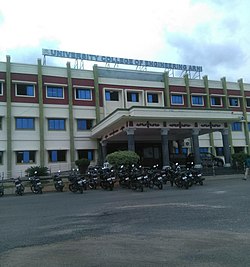
University of Engineering College, Arni
Aarani is a separate Education District in Tiruvannamalai District. There are two engineering colleges in Aarani: University College of Engineering of Anna University[24] and A.C.S Engineering College. Polytechnic Colleges, ITI and Arts & Science Colleges also located in Aarani.[citation needed]
The Govt. Boys High School, Govt. Girls High School, Subramaniya Sastri High School and more private higher secondary schools are located in Aarani. The affiliated body of AISECT under MCIT GoI: M/S MTECH Business Solutions (IT Training Division), is present in Aarani.[citation needed]
↑ M T Saju. "British Era palace falling apart in Arni". Times of India. Retrieved 4 July 2016. It was Maratha king Shahji (Shivaji's father) who handed over Arni with 100 villages to his commander Vedaji Bhaskar Punt in AD 1640
↑ HF Murland (1922). Baillie-Ki-Paltan: Being a History of the 2nd Battalion, Madras Pioneers 1759-1930. Naval and Military Press, Uckfield. p 80.
1 2 "Census Info 2011 Final population totals". Office of The Registrar General and Census Commissioner, Ministry of Home Affairs, Government of India. 2013. Retrieved 26 January 2014.
This page is based on this Wikipedia article Text is available under the CC BY-SA 4.0 license; additional terms may apply. Images, videos and audio are available under their respective licenses.