Devikapuram

Last updated

Devikapuram
Devikapuram back view.jpg
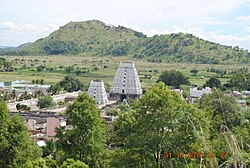
Temple View from hill
Nickname: 
Devikai
India Tamil Nadu location map.svg
Red pog.svg
Devikapuram
Location in Tamil Nadu, India
India location map 3.png
Red pog.svg
Devikapuram
Devikapuram (India)
Coordinates: 12°28′28″N79°20′51″E / 12.474433°N 79.347539°E / 12.474433; 79.347539
CountryFlag of India.svg  India
State Tamil Nadu
District Thiruvanamalai
Government
  BodyVillage Panchayat
Population
 (2001)
  Total27,786
Languages
  Official Tamil
Time zone UTC+5:30 (IST)
Vehicle registration TN 97
Sex ratio 1:1 /
Website http://www.devikapuram.in/
Devikapuram viewed from Hill DVM view frm Hill.jpg
Devikapuram viewed from Hill

Devikapuram, also called Devigai, is a town and a Panchayat board in Tiruvannamalai district, located in Tamil Nadu, India. The town is famous for handlooms, Silk weaving and ricemills, which process Arni Ponni rice. Located on the Polur - Sadras state highway, 45 kilometres from the city of Tiruvannamalai, also the district headquarters.

Contents

Location

Devikapuram is part of Tiruvannamalai district, Chetpet taluk, located in Polur-to-Chetput Road (SH-115). It is part of Thondai mandalam. It is a quiet & calm village without any industry. People lead a pleasant life by doing agriculture and weaving.

Devikapuram, the village is about 158 km(98 mi) South-West of Chennai. Also about 42 km West of Vandavasi (Wandiwash); 15 km East of Polur; 21 km South of Arani; 51 km North-East of Tiruvannamalai and 60 km South-East of Vellore. While going from Vandavasi, after Nedungunam comes Chetpet and in the same road towards Polur (West) comes Devikapuram. The Periyanaki amman temple located at north side of main road.

Demography

Devikapuram is a census town and most of the people are involved in textile business and Rice mills like its big neighbour Arni. Agamudaya Mudaliar, Sengundha Mudaliar, Tamil Jains are the prominent communities of the town.

Government and politics

Amenities

Nathan cable vision, Bsnl, Railwire,Tic fibre are the Internet Service Providers. KBC Wired And Wireless Broadband Communications (BSNL) are also available.

Economy

  1. Agriculture (Rice & Sugarcane)
  2. Milk
  3. Handloom & Power loom Silk saree production (extensively done by half of the population)
  4. Cattle rearing

Several commercial banks and ATMs are available.

Landmarks

  1. Periyanayagi Amman Temple
  2. Ponmalai Nathar Temple, aka Kanagagireeswar (on hill)
Devikapuram-sunset3 Devikapuram-sunset3.jpg
Devikapuram-sunset3

Transport

By Road

Devikapuram is located on State Highway 115.

Devikapuram Periyanayagi Temple Devikapuram.jpg
Devikapuram Periyanayagi Temple

This village has connecting bus from:

From Vandavasi: Chennai to Vandavasi (via Uthiramerur/Thennangur) – 128 approx km Vandavasi to Chetput – 27 km Chetput to Devikapuram – 12 km

From Arani: Arani – 21 km

From Polur: Polur to Devikapuram – 15 km

Buses are plying to Devikapuram from Chennai ( CMBT )round the clock with Bus No.148( Direct Bus) and Bus No. 131(Via Kanchipuram). Town and mofussil buses from Arni, Chetpet and Polur are available.

Rail

Air

Education

  1. Government boys school (Higher secondary)
  2. Government girls school (High school)
  3. Government elementary school
  4. Cluny Matriculation school (Private)
  5. RCM School (Elementary level)
  6. Annamalaiar College of engineering [1]

Hospitals

  1. Primary Health Center
  2. Few private clinics

Related Research Articles

<span class="mw-page-title-main">Vandavasi</span> Town in Tamil Nadu, India

Vandavasi, earlier called Wandiwash is a major town and a municipality in the Tiruvannamalai district of the Indian state of Tamil Nadu. The town is well known in the Carnatic history for the Battle of Wandiwash. Vandavasi town is also the largest manufacturer of kora artefacts including mats, shawls and vessels. As of 2011, the town had a population 74,320.

Chengam or Chengamma as on British records, is an important market town and a taluk headquarter in the Foot hills of Eastern ghats in Tiruvannamalai district of Tamil Nadu, India. Chengam is the gateway to the Chengam pass in the Eastern ghats between Javvadhu hills to the north and Chennakesava hills to the south. The town is also the center for various industrial activities which includes Sathanur dam hydro-electric project, Aavin milk processing plant and Periya Kolappadi SIDCO estate.

Kalambur is a selection grade town panchayat in Polur taluk, Tiruvanamalai district in the Indian state of Tamil Nadu, famous for its rice production. As of the 2011 census, the town had a population of 31,751.

<span class="mw-page-title-main">Polur</span> Market town in Tiruvannamalai District, Tamil Nadu.

Polur is a scenic town and a Religious site for Lord Narasimha called Sampathgiri, divisional headquarters and a market center in Tiruvannamalai district of Tamil Nadu in India. Located at the foothills of Javvadhi hills, a popular section of Eastern Ghats, Polur is often regarded as Gateway of Eastern ghats. Polur was once a eminent center of Tamil Jainism. The town is home to Dharani sugars, chemicals and fertiliser Pvt., Ltd, and number of agro based industries including coir industries. The famous Chittor - Cuddalore road passes through the town. The town is located 29 Kilometres north of city of Tiruvannamalai and 45 kilometres south of Vellore Metropolis.

Podaturpet is a Town under Pallipattu(Pallipet) Taluk in Thiruvallur district in the Indian state of Tamil Nadu.

Arani, officially spelled as Arni and also known as Periya arani, is a major commercial, industrial and cultural hub and also a divisional headquarter in the Tiruvanamalai district of Tamil Nadu, India. The town is the second largest urban center next to the district headquarters, Tiruvannamalai, and is administered by a selection grade municipality. Arni is home to silk weaving, spinning mills and agricultural industries. Famous Arni silk and a paddy variety named Arni Ponni, known for its rich aroma, originates from Arni. The town is often nicknamed as The Silk City. Arni also has a rich cultural heritage as it is a major center of Tamil Jainism.

Chetpet is a major town and a municipality in Tiruvannamalai district in the state of Tamil Nadu, India. Chetpet's major economical activity is processing paddy and the town is home to one of the largest organised paddy exchange markets of the state. Chetpet is one of the very few places of German colonisation in Indian history. A village called Nedungunam nearby has one of the Famous temples of Lord Rama. The temple is very famous and called Sri Yoga Rama temple.

Melmalayanur is located near Gingee, Tamil Nadu, India, 21 km from chetput and 21 km away from Gingee It is famous for the Goddess Angalaamman. Devotees across South India visit this temple to avail blessings of Angalaamman.

Perungattur is a village located in Tiruvannamalai district, Tamil Nadu, South India. It is suburb of Cheyyar town. Its 24 km away from the temple town Kanchipuram.

Arani taluk is a taluk of Tiruvannamalai district of the Indian state of Tamil Nadu. The headquarters is the town of Arani.

<span class="mw-page-title-main">Tiruvannamalai district</span> District of Tamil Nadu in India

Tiruvannamalai district is the largest and one of the 38 districts in the state of Tamil Nadu, in South India. It was formed in the year 1989 through the bifurcation of North Arcot into the Tiruvannamalai Sambuvarayar and Vellore Ambedkar districts. The city of Tiruvannamalai is the district headquarters.

Mullandrum is a village in Tiruvanamalai district in the state of Tamil Nadu, India. The postal code of Mullandrum is 632512. The name "Mulladrum" is derived from Mullai Vanam. Also called as "Mulladhiram".

Periya Kozhappalur is a village in Chetpet Taluk, Tiruvannamalai District, Tamil Nadu, India. Periya Kozhappalur is located 2 kilometres (1.2 mi) east of the state highway SH-4, between Arani and Chetpet, 14 kilometres (8.7 mi) from Arani, 40 kilometres (25 mi) from Vandavasi, and 11 kilometres (6.8 mi) from its taluk main town of Chetpet. Kolappalur is 47 kilometres (29 mi) from its district main city Tiruvannamalai. It is 132 kilometres (82 mi) from its state capital Chennai.

Kurumbhur, also named as Kurambur or Kurumbur, a village located at Cheyyar taluk, Thiruvannamalai district of Tamil Nadu|

Ariyathur is a village in Polur Taluk in Tiruvannamalai District of Tamil Nadu, India. It is located 47 km towards east from district headquarters Thiruvannamalai. 167 km from state capital Chennai.

Purisai is a village panchayat of Cheyyar Taluk. The village is famous for temples and festivals.

Kunnathur is a village in Arani Taluk in Tiruvannamalai District of Tamil Nadu State, India. It lies on the border between Tiruvannamalai District and Vellore District and is located 64 km north of the District Headquarters in Tiruvannamalai, 8 km from Arani, and 139 km from the state capital Chennai.

<span class="mw-page-title-main">Arni Fort bus terminus</span>

Arani Fort bus station, is the city of Arni's main bus station. Arni is the second largest town in Tiruvannamalai district after Tiruvannamalai city. It is in the central part of Arni town and is near the Arni Fort, hence its name.

Thurinjikuppam Thiruvannamalai District, Tamil Nadu, India, is located in the Polur Taluk, which belongs to the Arani Revenue Division. The famous Adiparasakthi Amman Temple is located here.

<span class="mw-page-title-main">Mullipattu</span> Place in Tamil Nadu, India

Mullipattu is a village located in Arani, Tiruvannamalai, India.

References

  1. https://web.archive.org/web/20111204022242/http://www.devikapuram.in/
  2. http://www.templenet.com/Tamilnadu/devikapuram.html
  3. https://web.archive.org/web/20090517113402/http://www.omarunachala.com/devikapuram.asp
  4. http://devikapuram.wordpress.com/
  1. "Home". annamalaiarengg.com.