Mannargudi is a Municipality in Thiruvarur district in the Indian state of Tamil Nadu. It is the headquarters of the Mannargudi taluk. The town is located at a distance of 28 km (17 mi) from the district headquarters Thiruvarur, 12 km from Needamangalam, 36 km from Kumbakonam, 40 km from Thanjavur, and 310 km (190 mi) from the state capital Chennai. Mannargudi is known for the Rajagopalaswamy temple, a prominent Vaishnavite shrine.

Madurai district is one of the 38 districts of the state of Tamil Nadu in southeastern India. The city of Madurai serves as the district headquarters. It houses the famous Sri Meenakshi Sundareshwarar temple and is situated on the banks of the river Vaigai. Thiruparankundram is one of the major tourist place in the district. As of 2011, the district had a population of 3,038,252 with a sex-ratio of 990 females for every 1,000 males. Aside from the city of Madurai, the larger towns are Melur, Vadipatti, Thirumangalam, Thirupparankundram, Peraiyur, and Usilampatti.

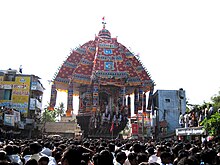
Thiruvarur also spelt as Tiruvarur is a municipality in the Indian state of Tamil Nadu. It is the administrative headquarters of Thiruvarur district and Thiruvarur taluk. The temple chariot of the Thyagaraja temple, weighing 360 tonnes (790,000 lb) and measuring 96 feet (29 m) tall is the largest temple chariot in India. Thiruvarur is the birthplace of Tyagaraja, Muthuswami Dikshitar and Syama Sastri, popularly known as the Trinity of Carnatic music of the 18th century CE. Thiruvarur Thiyagarajaa Swaamy temple is older than Tanjore big temple.

Nagapattinam district is one of the 38 districts of Tamil Nadu state in southern India. Nagapattinam district was carved out by bifurcating the erstwhile composite Thanjavur district on 19 October 1991. The town of Nagapattinam is the district headquarters.
Virudhunagar District is a district of Tamil Nadu state in south India. Virudhunagar is the district headquarters of Virudhunagar district. Virudhunagar district was formed by the separation of Old Ramanathapuram District G.O passed on 08,March 1985 & formed in 15,March 1985 into Ramanathapuram District, Sivagangai District and the west part as Virudhunagar District. Virudhunagar District was formerly called Karmavirer Kamarajar District. As of 2011, Virudhunagar district had a population of 1,942,288 with a sex-ratio of 1,007 females for every 1,000 males. Sivakasi is the most populous and largest city in the district.

Muthupet is a panchayat town and taluk in the Thiruvarur district in the Indian state of Tamil Nadu. It is also known as Pearlpet. Muthupet comes under the Thiruthuraipoondi assembly constituency which elects a member to the Tamil Nadu Legislative Assembly every five years. The current member of the legislative assembly (MLA) is Marimuthu of the Communist Party of India, a part of the Nagapattinam, which elects its member of parliament (MP) every five years. The Muthupet city in-town panchayat was constituted in 1962. The town comes under the administrative territory of the Thiruvarur District. It extends over an area of 11.80 km2.

Needamangalam or Nidamangalam, is a town panchayat in Thiruvarur district in the Cauvery Delta of the Indian state of Tamil Nadu. Needamangalam was originally part of the composite Tanjore Dist during the British Raj period until 1997. In the 18th and 19th century, it was also called Yamunambalpuram. Needamangalam is the headquarters of the Needamangalam Taluk. The town is located 30 km east of Thanjavur, 80 km east of Tiruchirappalli and 318 km south of Chennai. Needamangalam is a junction for two busy highways, National Highway 67 and State Highway SH 66.

Pattukkottai is a major town in Thanjavur district in the Indian state of Tamil Nadu and also important town in Delta districts and Commercial town of Thanjavur, Thiruvarur and Pudukkottai district Coastal areas. The town came to prominence throughout Southern India after the construction of the fort by Vanaji Pandithar, a feudatory of the Thanjavur Maratha ruler Shahuji I in 1686–87. The recorded history of Pattukkottai is known from the 17th century and has been ruled, at different times, by the Thanjavur Marathas and the British. It is the headquarters of the Pattukkottai taluk of Thanjavur district and is one of the two municipalities in the district.

Thiruthuraipoondi is a municipality in Tiruvarur district in the Indian state of Tamil Nadu. Thiruthuraipoondi is an agricultural town located south of Thiruvarur district. The town is located at a distance of 28 km (17 mi) from the district headquarters Thiruvarur.

Valangaiman is a town Panchayat in the Valangaiman taluk of Thiruvarur district in the Indian state of Tamil Nadu. It is the headquarters of Valangaiman Taluk.

East Coast Road (ECR), combination of SH-49, NH-332A, NH-32, officially known as Mutthamizh Arignar Kalaignar Road, is a two-lane highway in Tamil Nadu, India, built along the Bay of Bengal coast. It connects Tamil Nadu's state capital Chennai with Kanyakumari via Puducherry, Cuddalore, Chidambaram, Sirkali, Thirukkadaiyur, Tharangambadi, Karaikal, Nagore, Nagapattinam, Thiruthuraipoondi, Muthupet, Adirampattinam, Manora,Manamelkudi, Mimisal, Ramanathapuram, Rameswaram,Thoothukudi, Tiruchendur, Uvari, Kudankulam. The total length of the road is about 777 km between Chennai and Kanyakumari.

Thanjavur district is one of the 38 districts of the state of Tamil Nadu, in southeastern India. Its headquarters is Thanjavur (Tanjore). The district is located in the delta of the Cauvery River and is mostly agrarian.

Tiruppur District is one of the 38 districts of the Indian state of Tamil Nadu, formed in 22 February 2009. Dharapuram was the largest taluk by area in the district. The district is well-developed and industrialized. The Tiruppur banian industry, the cotton market, Kangeyam bull and Uthukkuli butter, among other things, provide for a vibrant economy. The city of Tiruppur is the administrative headquarters for the district. As of 2011, the district had a population of 2,479,052 with a sex-ratio of 989 females for every 1,000 males.
Thiruthuraipoondi taluk is a taluk in Thiruvarur district of the Indian state of Tamil Nadu. The headquarters of the taluk is the town of Thiruthuraipoondi.

Koothanallur is a town in Tiruvarur district in the South Indian state of Tamil Nadu. The town is located at a distance of 20 km (12 mi) from the district headquarters Tiruvarur and 350 km (220 mi) from the state capital Chennai.
The Pamaniyar or Pamani River is a non-perennial river in the Tiruvarur district of the Indian state of Tamil Nadu. The river is part of the Kaveri delta, and is in the southern part of that system. The Pamaniyar originates as a distributary of the Vennaaru River, which it branches off from at a dam northwest of Needamangalam in Needamangalam taluk. It flows south from this point into Mannargudi taluk, passing to the east of Mannargudi and Asesham. It continues to flow south, where its course is parallel to State Highway 202 for some distance. After it is joined on its right bank by the Kannanar River, its largest tributary, it flows southeast into Thiruthiraipoondi taluk. It then passes to the west of Muthupet before emptying into Muthupet Lagoon.
Erukattur is a village in the Koothanallur taluk of Tiruvarur district in Tamil Nadu, India. The village is located 10.2 km southwest of Thiruvarur and 10.5 km southeast of Koradacheri. Very recently the taluk was changed from Kudavasal to Koothanallur.
Munnavalkottai is a village in the Needamangalam taluk of Thiruvarur district in the Indian state of Tamil Nadu.
The Koraiyar River is a non-perennial river in the Tiruvarur district of the Indian state of Tamil Nadu. It is in the southern part of the Kaveri delta that covers much of the region of Chola Nadu. The Koraiyar begins as a distributary of the Vennaaru River where that river is dammed northwest of Needamangalam in Needamangalam taluk. After branching off from the Vennaaru, it flows southeast to the southwest of Needamangalam. It continues southeast for some distance, then turns sharply to the east. It follows this eastern course for some distance then turns southward west of Podakkudi. It follows a southern course through Mannargudi taluk then turns to the southwest north of Thillaivilagam in Thiruthiraipoondi taluk. Flowing to the east of Muthupet, it turns southeast and subsequently empties into Muthupet Lagoon.