Mayiladuthurai is a Selection Grade Municipality and district headquarter of Mayiladuthurai district in Tamil Nadu, India. The town is located at a distance of 256 km (159 mi) from the state capital, Chennai.

Nagapattinam is a town in the Indian state of Tamil Nadu and the administrative headquarters of Nagapattinam district. The town came to prominence during the period of Medieval Cholas and served as their important port for commerce and east-bound naval expeditions. The Chudamani Vihara in Nagapattinam constructed by the Srivijayan king Sri Mara Vijayattungavarman of the Sailendra dynasty with the help of Rajaraja Chola I was an important Buddhist structure in those times. Nagapattinam was settled by the Portuguese and, later, the Dutch under whom it served as the capital of Dutch Coromandel from 1660 to 1781. In November 1781, the town was conquered by the British East India Company. It served as the capital of Tanjore district from 1799 to 1845 under Madras Presidency of the British. It continued to be a part of Thanjavur district in Independent India. In 1991, it was made the headquarters of the newly created Nagapattinam District. Nagapattinam is administered by a Special grade municipality covering an area of 17.92 km2 (6.92 sq mi) and had a population of 102,905 as of 2011.

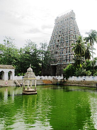
Thiruvarur also spelt as Tiruvarur is a municipality in the Indian state of Tamil Nadu. It is the administrative headquarters of Thiruvarur district and Thiruvarur taluk. The temple chariot of the Thyagaraja temple, weighing 360 tonnes (790,000 lb) and measuring 96 feet (29 m) tall is the largest temple chariot in India. Thiruvarur is the birthplace of Tyagaraja, Muthuswami Dikshitar and Syama Sastri, popularly known as the Trinity of Carnatic music of the 18th century CE. Thiruvarur Thiyagarajaa Swaamy temple is older than Tanjore big temple.

Thiruthuraipoondi is a municipality in Tiruvarur district in the Indian state of Tamil Nadu. Thiruthuraipoondi is an agricultural town located south of Thiruvarur district. The town is located at a distance of 28 km from the district headquarters Thiruvarur.

Valangaiman is a town Panchayat in the Valangaiman taluk of Thiruvarur district in the Indian state of Tamil Nadu. It is the headquarters of Valangaiman Taluk.
Podakkudi(Shortened as PDK) is a village in Thiruvarur district in the South Indian state of Tamil Nadu. The town is located at a distance of 20 km (12 mi) from the district headquarters Thiruvarur and 272 km (169 mi) from the state capital Chennai. Podakkudi is known for the Big Pallivasal, a prominent Islamic shrine. Nearby town is Koothanallur and the nearby villages are Atthikadai and Budamangalam.

Thiruvarur district is one of the 38 districts in the Tamil Nadu state of India. As of 2011, the district had a population of 1,264,277 with a sex-ratio of 1,017 females for every 1,000 males.
Saliyamangalam is a village in the Papanasam taluk of Thanjavur district, Tamil Nadu, India. It is one of the two places in Tamil Nadu where the Bhagavathar Melas are held, the other being Melattur.
Papanasam taluk is a taluk of Thanjavur district of the Indian state of Tamil Nadu. The headquarters of the taluk is the town of Papanasam.
Mannargudi taluk is a taluk in Thiruvarur district of the Indian state of Tamil Nadu. The headquarters of the taluk is the town of Mannargudi.
Nannilam taluk is a taluk in Thiruvarur district of the Indian state of Tamil Nadu. The headquarters of the taluk is the town of Nannilam.
Tiruvarur Taluk is a taluka in Thiruvarur district of the Indian state of Tamil Nadu. The headquarters of the taluk is the town of Tiruvarur.
Paravakkottai is a village in the Mannargudi Taluk of Thiruvarur district, Tamil Nadu, India. It is surrounded by many Rivers and Ponds. Paravakkottai consist of streets like North street, West street, South street, Middle street, Thilagar Street etc. The streets are elegantly arranged in such a manner that all the streets end at the river bed. There are many temples. The nearby town is Mannargudi in north and Madukkur in the south.
The Vettar River or Vettaaru is a river in the Kaveri delta that flows through the Thanjavur, Tiruvarur, and Nagapattinam districts of the Indian state of Tamil Nadu.
Kappanamangalam is a village in the Kudavasal taluk of Tiruvarur district in Tamil Nadu, India.
Sathanur may refer to several places in India:
Walajabad taluk is a taluk in the Kanchipuram district of Tamil Nadu, India. At the 2011 Census of India, the taluk covered an area of 339.03 square kilometres (130.90 sq mi) with a population of 125,868. The headquarters of the taluk is the town of Walajabad.
Munnavalkottai is a village in the Needamangalam taluk of Thiruvarur district in the Indian state of Tamil Nadu.

Melamaravakkadu is a village in Thiruvarur district in Tamil Nadu, India.