
Arcot is a town in Ranipet district in the state of Tamil Nadu, India. Located on the southern banks of Palar River, the city straddles a trade route between Chennai and Bangalore or Salem, between the Mysore Ghat and the Javadi Hills.
Panruti is a town, municipality and taluk headquarters of Cuddalore district, Tamil Nadu, India. Panruti is located between Cuddalore and Neyveli. Panruti is famous for jackfruits and cashew nuts. The jackfruit grown here is exported worldwide and is very sweet. It is a business capital of Cuddalore district. Kananchavadi one of the villages in panruti taluk, famous for palm juice. It has been a great commercial area for more than 200 years. The name Panruti came from the Tamil words "Pann" and "Urutti" meaning "composing song and music", as the place is where many saints and great religious singers such as nayanmars and vainavas sung. A 150-year-old government school was built here by the British East India Company and a more-than-1000-year-old temple Veerattaneswarar temple is nearby in Thiruvathigai. As of 2011, the town had a population of 60,323.

Thiruvarur also spelt as Tiruvarur is a municipality in the Indian state of Tamil Nadu. It is the administrative headquarters of Thiruvarur district and Thiruvarur taluk. The temple chariot of the Thyagaraja temple, weighing 360 tonnes (790,000 lb) and measuring 96 feet (29 m) tall is the largest temple chariot in India. Thiruvarur is the birthplace of Tyagaraja, Muthuswami Dikshitar and Syama Sastri, popularly known as the Trinity of Carnatic music of the 18th century CE. Thiruvarur Thiyagarajaa Swaamy temple is older than Tanjore big temple.
Meenambakkam is a southern neighbourhood of Chennai in the Indian state of Tamil Nadu. It is home to Chennai International Airport, the Airports Authority of India regional office, and the DGQA Complex. It was under the reign of the Pallava kingdom. The name Meenambakkam signifies that it is a settlement near the coast. Pakkam means a settlement near to the coast. Meenambakkam was cherished with lakes, ponds and borderlines the Adyar river. This makes it a rich source of fishes. Hence the name Meenambakkam was coined.

Krishnagiri district is one of the 38 districts of the state of Tamil Nadu, in India. This district is carved out from Dharmapuri District by 2004. The municipal town of Krishnagiri is the district headquarters. In Tamil Nadu, e-Governance was first introduced at Krishnagiri district under the National e-Governance Project (NEGP) in revenue and social welfare departments on a pilot basis. The district is one of the largest producers of mangoes in India. As of 2011, the district had a population of 1,879,809 with a sex-ratio of 958 females for every 1,000 males. Hosur is the most populous city in the district.
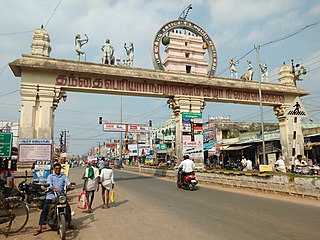
Tiruchengode is a selection-grade municipality located in western part of southern Indian state of Tamil Nadu. It is famous for the ancient hilltop Ardhanareeswarar Temple, dedicated to the unique combined male-female form of Lord Shiva and Goddess Parvathi. This important place of pilgrimage is mentioned in the Tamil work Silapathikaram as 'Nedulkundru' and is celebrated in the hymns of Saivite saints. The equally famous Chenkottu Velavar Temple, dedicated to Lord Murugan, is situated on the same hill. As of 2011, the town had a population of 95,335. As per 2011 population, Tiruchengode is the largest city in Namakkal district. It is also famous for rig business.

Cuddalore District is one of the 38 districts in the state of Tamil Nadu in India.

Dharapuram is a town situated along the banks of Amaravati River in Tiruppur district in the Indian state of Tamil Nadu. Dharapuram is one of the oldest towns in South India and was the capital of Kongu Nadu under the Cheras, Western Ganga Dynasty and later Kongu Cholas, at which time it was known as Viradapuram. Amaravathi River flows through the town. As of 2011, the town had a population of 67,007. The city houses famous temples including Agatheeswarar Temple, Kaadu Hanumanthasamy temple and many other old temples.
Madhavaram is a neighbourhood of Chennai, Tamil Nadu, India. Located in the northern part of Chennai, it is also a taluk in Chennai District and a zone in Greater Chennai Corporation. It is located in between Perambur and Kodungaiyur. As of 2011, the neighbourhood had a population of 119,105. The Chennai district was expanded on 16 August 2018 by transferring Madhavaram taluk from Tiruvallur district to Chennai district.

Pattukkottai is a major town in Thanjavur district in the Indian state of Tamil Nadu and also important town in Delta districts and Commercial town of Thanjavur, Thiruvarur and Pudukkottai district Coastal areas. The town came to prominence throughout Southern India after the construction of the fort by Vanaji Pandithar, a feudatory of the Thanjavur Maratha ruler Shahuji I in 1686–87. The recorded history of Pattukkottai is known from the 17th century and has been ruled, at different times, by the Thanjavur Marathas and the British. It is the headquarters of the Pattukkottai taluk of Thanjavur district and is one of the two municipalities in the district.

Theni Allinagaram is a valley town and a municipality, situated in the Indian state of Tamil Nadu at the foothills of Western Ghats. It is the headquarters of the Theni district, located at a distance of 70 km from Madurai. As of 2011, the town had a population of 94,453. The metro area had the population of 202,100. It is known for the large-scale trading of garlic, cotton, cardamom, grapes, bananas, mango and chilli. It hosts the second largest weekly market in Tamil Nadu and the fourth largest in South India.
Tindivanam is a municipality in Viluppuram district in the Indian state of Tamil Nadu. It is the second largest town in Villupuram District after the headquarters town Villupuram. Important roads from north to south Tamil Nadu pass through Tindivanam and similarly from west to east.

Thanjavur district is one of the 38 districts of the state of Tamil Nadu, in southeastern India. Its headquarters is Thanjavur (Tanjore). The district is located in the delta of the Cauvery River and is mostly agrarian.
PerperiyanKuppam (PPK), also known as Kallodaavi among neighboring peoples, is a village in Panruti, in the western end of Cuddalore District of Tamil Nadu State, India.
Vadaseri South is a major village in the Orathanadu taluk of Thanjavur district in the Indian state of Tamil Nadu. Vadaseri comes under the Orathanadu constituency which elects a member to the Tamil Nadu Legislative Assembly once every five years and it is a part of the Thanjavur which elects its Member of Parliament (MP) once in five years. The village is administered by the Vadaseri panchayat, which covers an area of 12.2826 km2 (4.7423 sq mi). As of 2011, the village had a population of 4,810. Most of the population belongs to the Agamudaiyar-Thevar Community who maintain strong cultural and social bindings.The village is a part of the fertile Cauvery delta region and agriculture is the major occupation. Roadways and railways are the major mode of transportation to Vadaseri, the nearest railway stations are Mannargudi and Pattukkottai and the nearest international airport is Tiruchirapalli Airport, located 100 km (62 mi) away from the village, in the city of Tiruchirappalli.
Siruvalur is a village in Ariyalur district, Tamil Nadu, India. The village has its own government high school which it is planning to upgrade to a higher secondary school. Siruvalur is located at 1 km from National Highway 227 (India) Tiruchirapalli to Chidambaram. Siruvalur is 12 km from district headquarters Ariyalur.
Aarani taluk is a taluk of Thiruvannamalai district of the Indian state of Tamil Nadu. The headquarters is the town of Aarani.

Tiruvannamalai district is the second largest district in Tamil Nadu by area after Dindigul District and one of the 38 districts in the state of Tamil Nadu, in South India. It was formed in the year 1989 through the bifurcation of North Arcot into the Tiruvannamalai Sambuvarayar and Vellore Ambedkar districts. The city of Tiruvannamalai is the district headquarters.
Paravakkottai is a village in the Mannargudi Taluk of Thiruvarur district, Tamil Nadu, India. It is surrounded by many Rivers and Ponds. Paravakkottai consist of streets like North street, West street, South street, Middle street, Thilagar Street etc. The streets are elegantly arranged in such a manner that all the streets end at the river bed. There are many temples. The nearby town is Mannargudi in north and Madukkur in the south.
Nangaimozhi is a village in the district of Tuticorin, Tamil Nadu, India. It is located 55 km from Tirunelveli, 52 km from Tuticorin and 17 km from Thiruchendur. The nearest airport is Thiruvananthapuram airport. Temples in Nangaimozhi include Ganapathi, Manthira Murthy, Parameswari Amman and Shiva.
