Related Research Articles
The South Pennar River is a river in India. Bangalore, Hosur, Krishnagiri,Kaveripattinam, and Cuddalore are the important cities on the banks of South Pennar river. This is the second longest river in Tamil Nadu, with a length of 497 km, after the Kaveri. Chandapura, Anekal, Hosur, Bagalur, and Chengam are the major industrial settlements on its banks. The river is severely polluted by industrial waste as it flows through major industrial areas in the eastern suburbs of Bangalore, Industrial parks of Hosur and Chengam.

Bhavani is an interstate Indian river which flows through Indian states of Kerala and Tamil Nadu, India. It originates from the Western Ghats and is one among the three rivers of Kerala which flows in eastward direction.

Chola Nadu is a cultural region of the Tamil Nadu state in southern India. It encompasses the lower reaches of the Kaveri River and its delta, and formed the cultural homeland and political base of the Chola Dynasty which ruled large parts of South India and parts of Sri Lanka between the 9th and 13th centuries CE. Uraiyur served as the early Chola capital, then medieval Cholas shifted to Thanjavur and later cholas king Rajendra Chola I moved the capital to Gangaikonda Cholapuram in Ariyalur in the 11th century CE.
Thoothukudi District is one of the 38 districts of Tamil Nadu state in southern India. The district was formed by bifurcation of Tirunelveli district on 20 October 1986. Thoothukudi is the district headquarters and largest city of the district. The district is known for fishing as well as pearl cultivation, with an abundance of pearls being found in the seas offshore. Thoothukudi district has many historical sites such as Adichanallur and the ancient trade port of Korkai.

Parambikulam Dam is an embankment dam on the Parambikulam River, Parambikulam located in the Palakkad district in the Western Ghats of Kerala, India, ranks number one in India as well as in the top ten embankment dams in the world in volume in the year 2000.
The Western Coastal Plains is a strip of coastal plain 50 kilometres in width between the west coast of India and the Western Ghats hills, which starts near the south of the Tapi River. The plains are located between the Western Ghats and the Arabian Sea. The plains begin at Gujarat in the north and end at Tamil Nadu in the south. It includes the states of Gujarat, Maharashtra, Goa, Karnataka, Kerala, and Tamil Nadu. The region consists of three sections: the northern part of the coast is called the Konkan, the central stretch is called the Kanara or the "Karavali", while the southern stretch is referred to as the Malabar Coast. On its northern side there are two gulfs: the Gulf of Khambat and the Gulf of Kutch. The rivers along the coast form estuaries and provide conditions ideal for pisciculture. Because of the presence of less coastal land in this part, it will be affected more by the global warming.

Thanjavur district is one of the 38 districts of the state of Tamil Nadu, in southeastern India. Its headquarters is Thanjavur. The district is located in the delta of the Cauvery River and is mostly agrarian.
Punnappuzha (Malayalam:പുന്നപ്പുഴ) is a tributary of Karimpuzha, which is the biggest tributary of the Chaliyar river in Kerala, India.
Madurantakam taluk is a taluk of Chengalpattu district of the Indian state of Tamil Nadu. The headquarters of the taluk is the town of Madurantakam. Madurantakam taluk is bounded by Chengalpattu taluk in north, Uthiramerur taluk of Kanchipuram district in West, Thirukklaukkundram Taluk in north east and Tindivanam lauk of Villupuram district in south.
The Sarabanga River is a river flowing in the Salem district of the Indian state of Tamil Nadu. The origin of the river is traditionally placed at the Servarayan hills in Tamil Nadu. The river fulfills demands for agricultural irrigation in Danishpet village. The Sarabanga flows through the towns of Danishpet, Omalur, Thoppur, Tharamangalam, Dhadhapuram, Idappadi, Chettipatti, Peramachipalayam, and Thevur, and joins the Kaveri River near Annamar Kovil before flowing into the Bay of Bengal. Dams on the river are located at Peramachipalayam.
The Thirumanimutharu River originates form Manjavadi village in the Shevaroy Mountain Range and flows through the Salem and Namakkal districts of the Indian state of Tamil Nadu. It rises in the Yercaud hills. Thirumanimutharu River joins the Cauvery at the Nanjai Edayar village in Namakkal.
Thirumalairajan is a river flowing in the Thanjavur, Tiruvarur and Nagapattinam districts of the Indian state of Tamil Nadu and Karaikal district of Puducherry. The river splits from Kudamurutti, a tributary of Kaveri river at Rajagiri near Papanasam, Thanjavur district. The river enters Bay of Bengal at Tirumalarajanpattinam near Karaikal.The river has a 150 years old bridge built by a king, who ruled the nearby places of the river.The bridge is also named after the river, the thirumalairajan river bridge.
Kundha is a river flowing in the Erode district of the Indian state of Tamil Nadu.
Upparu River is a river flowing in the Tirupur district of the Indian state of Tamil Nadu.
The Koraiyar River is a river in the Ambasamudram taluk of the Tirunelveli district of the Indian state of Tamil Nadu. It is a right-bank tributary of the Thamirabarani River, which flows through Tirunelveli and Thoothukudi districts. It is formed by the confluence of the minor Vadakkur Koraiyar and Therkku Koraiyar rivers, which are its headwater streams, on the eastern slopes of the Western Ghats. It flows for a total length of 13.2 kilometres (8.2 mi) before flowing into the Kannadian channel near the village of Vellankuli upstream of the Kannadian anicut. The channel bypasses the anicut before joining the Thamirabarani downstream and to the east of the dam. Along its course it is joined by three tributaries, the Vandal Odai, Elumichaiyar, and Koppuraiyar rivers. The Koraiyar's drainage basin covers an area of 75.75 square kilometres (29.25 sq mi) and has a recorded maximum flood discharge of 12000 cusecs.
Aluthakanniar is a river flowing in the Tirunelveli district of the Indian state of Tamil Nadu. It is one of the tributaries of Chittar River, which joins Tamiraparani near Tirunelveli. It arises in the eastern slopes of the Western Ghats, and forms the Old Kutralam falls as it descends down the mountain. It flows 10 kilometres (6 mi) towards northeast before joining its main river Chittar near Kadapagothi village.
Gundar River flows through Madurai, Virudhunagar and Ramanathapuram districts of the Indian state of Tamil Nadu. The origin of Gundar is Sathuragiri hills, and it flows through Tirumangalam, Kamuthi and ends itself into Gulf of Mannar.
Mullaiyar is a river flowing in the Tiruvarur district of the Indian state of Tamil Nadu. It is a tributary of the Kaveri river, and flows into the Bay of Bengal.

The Mayar River is one of the tributaries of the Bhavani in Tamil Nadu, South India. The Mayar river originates from a small town called Mayar off the Masinagudi–Ooty road. This is a natural line of separation between the state of Karnataka and Tamil Nadu and a separation between the forest of Bandipur National Park and the Mudumalai sanctuary to the south. The Mayar River Gorge is 20 kilometres (12 mi) long and is also called the Mayar Canyon. The river flows into the gorge below Theppakadu in a roaring waterfall called Mayar Falls. This river is checked by Bhavanisagar Dam on the plains near Satyamangalam, along with the Bhavani River.
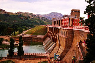
The Papanasam dam also known as Karaiyar Dam is located 49 kilometres (30 mi) away from Tirunelveli in Tamil Nadu, India. The dam is used to irrigate 86,107 acres (34,846 ha) of paddy fields in Tirunelveli and Tuticorin districts.
