
The Kaveri is one of the major Indian rivers flowing through the states of Karnataka and Tamil Nadu. The Kaveri River rises at Talakaveri in the Brahmagiri range in the Western Ghats, Kodagu district of the state of Karnataka, at an elevation of 1,341 m above mean sea level and flows for about 800 km before its outfall into the Bay of Bengal. It reaches the sea in Poompuhar, in Mayiladuthurai district. It is the third largest river – after Godavari and Krishna – in southern India, and the largest in the state of Tamil Nadu, which, on its course, bisects the state into north and south. In ancient Tamil literature, the river was also called Ponni.

Erode District is one of the 38 districts in the state of Tamil Nadu in India. It was the largest district by area in the state before the formation of Tirupur District in 2009. The headquarters of the district is Erode. It is divided into two revenue divisions, Erode and Gobichettipalayam, and is further subdivided into 10 taluks. Erode District was a part of Coimbatore District before its division into two on 17 September 1979. It covers an area of 5,722 square kilometres (2,209 sq mi), and as of 2011, had a population of 2,251,744.

The Amaravati River is the longest tributary of Kaveri River in the fertile districts of Udumalpet, Dharapuram and Karur Tamil Nadu state, South India.

The Noyyal River is a small river in Western Tamil Nadu, and a tributary of Kaveri River. It rises from the Vellingiri hills in the Western Ghats in Tamil Nadu, very closer in proximity to Kerala border, and flows through many villages and the cities of Coimbatore, and Tirupur. Then finally, the river drains into the Kaveri River at Noyyal, a village in Karur district named after the river itself. The river's basin is 180 km (110 mi) long and 25 km (16 mi) wide and covers a total area of 3,500 km2 (1,400 sq mi). Cultivated land in the basin amounts to 1,800 km2 (690 sq mi) while the population density is 120 people per km² (311/mi²) in the countryside, and 1000 people per km² (2590/mi²) in the cities. The area is known for its scanty rainfall and the development of the Noyyal River Tanks System to hold any overflow from the rains plus the water of the Northeast and Southwest monsoon season was ecologically important. Kausika river, which originates along the northern side of Coimbatore district in the Western Ghats along with its consequent streams, lake and pond systems is an important tributory of the river. The 173 km (107 mi) long tributary of the Kaveri River filled 32 tanks. These interconnecting tanks held the water flowing from the Noyyal.

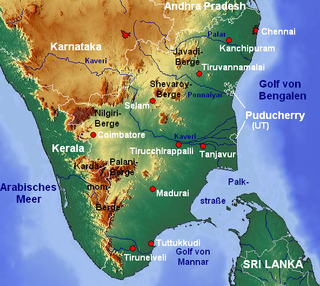
Palar is a river of southern India. It rises in the Nandi Hills in Chikkaballapura district of Karnataka state, and flows 93 kilometres (58 mi) in Karnataka, 33 kilometres (21 mi) in Andhra Pradesh and 222 kilometres (138 mi) in Tamil Nadu before reaching its confluence into the Bay of Bengal at Vayalur about 75 kilometres (47 mi) south of Chennai. It flows as an underground river for a long distance only to emerge near Bethamangala town, from where, gathering water and speed, it flows eastward down the Deccan Plateau. The Towns of Bethamangala, Santhipuram, Kuppam, Ramanaickenpet, Vaniyambadi, Ambur, Melpatti, Gudiyatham, Pallikonda, Anpoondi, Melmonavoor, Vellore, Katpadi, Melvisharam, Arcot, Ranipet, Walajapet, Kanchipuram, Walajabad, Chengalpattu, Kalpakkam, and Lattur are located on the banks of the Palar River. Of the seven tributaries, the chief tributary is the Cheyyar River.

Bhavani is an interstate Indian river which flows through Indian states of Kerala and Tamil Nadu, India. It originates from the Western Ghats and is one among the three rivers of Kerala which flows in eastward direction.

The Vaigai is a river in the Tamil Nadu state of southern India; it passes through the towns of Theni, Dindigul and Madurai. It originates in Varusanadu Hills, the Periyar Plateau of the Western Ghats range, and flows northeast through the Kambam Valley, which lies between the Palani Hills to the north and the Varushanad Hills to the south. The Vattaparai Falls are located on this river. As it rounds the eastern corner of the Varushanad Hills, the river turns southeast, running through the region of Pandya Nadu. Madurai, the largest city in the Pandya Nadu region and its ancient capital, lies on the Vaigai. The river empties into the Palk Bay near Alagankulam, close to Pamban Bridge in Ramanathapuram District.

The Thamirabarani or Tamraparni or Porunai is a perennial river that originates from the Agastyarkoodam peak of Pothigai hills of the Western Ghats, above Papanasam in the Ambasamudram taluk. It flows through Tirunelveli and Thoothukudi districts of the Tamil Nadu state of southern India into the Gulf of Mannar. It was called the Tamraparni River in the pre-classical period, a name it lent to the island of Sri Lanka. The old Tamil name of the river is Porunai. From the source to sea, the river is about 128 kilometres (80 mi) long and is the only perennial river in Tamil Nadu. This river flows towards north direction initially. However, it changes to east direction later.
Chittar River and its five tributaries and numerous other contributing streams originate in the Courtallam hills of Tenkasi District in the state of Tamil Nadu in southern India. Together with its tributaries and streams, the Chittar River serves as an important source of irrigation for the region and is a major tributary of the Tambaraparani River along with the Manimuthar River.

Manimuthar River originates on the eastern slopes of Western Ghats in Tirunelveli District of the state of Tamil Nadu in southern India. It is a major tributary of the Thamirabarani River.
The Palani Hills Wildlife Sanctuary and National Park is a proposed protected area in Dindigul District, Tamil Nadu India. The park will be an upgrade and expansion of the 736.87 km2(PRO) Palani (Kodaikanal) Wildlife Sanctuary which was to be established in 2008. The park includes about 36% of the 2,068 square kilometres (798 sq mi) in the Palani Hills. The park is located between latitude 10°7'–10°28' N and longitude 77°16'–77°46' E. Central location is 1.5 kilometres (0.93 mi) east northeast of Silver Cascade Waterfall and 4 kilometres (2.5 mi) E X NE of Kodaikanal Lake.

The Vellar River is a river in the Indian state of Tamil Nadu. It originates in the Kalrayan Hills, and flows generally eastward through Salem, Perambalur, and Cuddalore districts, before flowing into the Bay of Bengal near Parangipettai. The river has a total length of 150 kilometres (93 mi), and its drainage basin covers an area of 7,504.346 square kilometres (2,897.444 sq mi) in Cuddalore, Perambalur, Salem, Kallakurichi, Ariyalur, Namakkal, Tiruchirappalli, and Dharmapuri districts.
The Sarabanga River is a river flowing in the Salem district of the Indian state of Tamil Nadu. The origin of the river is traditionally placed at the Servarayan hills in Tamil Nadu. The river fulfills demands for agricultural irrigation in Danishpet village. The Sarabanga flows through the towns of Danishpet, Omalur, Thoppur, Tharamangalam, Dhadhapuram, Idappadi, Chettipatti, Peramachipalayam, and Thevur, and joins the Kaveri River near Annamar Kovil before flowing into the Bay of Bengal. Dams on the river are located at Peramachipalayam.
Mamannar Kalingarayan Anicut is a dam constructed on the Bhavani river in the South Indian state of Tamil Nadu. It is located just before Kooduthurai where Bhavani combines with Cauvery, in Bhavani, Erode.

The Manimuthar Dam is located in Manimutharu 50.8 kilometres (31.6 mi) away from Tirunelveli in Tamil Nadu, India. It is the biggest reservoir of the Tirunelveli district. This dam was built in 1958 near Singampatti and Kallidaikurichi, by the then Tamil Nadu Chief Minister K. Kamaraj and K T Kosalram MP to prevent mixing of rainwater with the Bay of Bengal during the rainy season. It can hold water up to 118 feet. The dam is 5,511 million cubic feet. The total length of the dam is 3 km It irrigated around 65,000 acres of areas in the northern part of the Nanguneri Taluk and Thisayanvilai and southern Veeravanallur, Karispalpatti which are not irrigated by Pachaiyaaru in Tirunelveli district. The downstream joins River Thamirabarani in Kallidaikurichi after 6 km of its journey.
Manimuthar is the name of four different rivers in Tamil Nadu, India:
The Pambar River is a tributary of the Thenpennai River in the Krishnagiri and Tirupattur districts of the Indian state of Tamil Nadu.
Palar is a river in the Indian states of Karnataka and Tamil Nadu. It originates near Guthiyalathur in Bhavani Taluk of Erode district in Tamil Nadu and forms border between Karnataka and Tamil Nadu. Later, it flows into the Kaveri River near Palar in Karnataka and Tamil Nadu.

The Vellar River or South Vellar River is a non-perennial river in the Indian state of Tamil Nadu that flows southeast into the Palk Strait, part of the Bay of Bengal.