Related Research Articles
Tamil Nadu is the southern-most state of India. The tenth largest Indian state by area and the sixth largest by population, Tamil Nadu is the home of the Tamil people, whose Tamil language—one of the longest surviving classical languages in the world—is widely spoken in the state and serves as its official language. The capital and largest city is Chennai.

The Kaveri is one of the major Indian rivers flowing through the states of Karnataka and Tamil Nadu. The Kaveri River rises at Talakaveri in the Brahmagiri range in the Western Ghats, Kodagu district of the state of Karnataka, at an elevation of 1,341 m above mean sea level and flows for about 800 km before its outfall into the Bay of Bengal. It reaches the sea in Poompuhar, in Mayiladuthurai district. It is the third largest river – after Godavari and Krishna – in southern India, and the largest in the state of Tamil Nadu, which, on its course, bisects the state into north and south. In ancient Tamil literature, the river was also called Ponni.
The South Pennar River is a river in India. Bangalore, Hosur, Tiruvannamalai, and Cuddalore are the important cities on the banks of South Pennar river. This is the second longest river in Tamil Nadu, with a length of 497 km, after the Kaveri. Chandapura, Anekal, Hosur, Bagalur and Chengam are the major industrial settlements on its banks. The river is severely polluted by industrial waste as it flows through major industrial areas in the eastern suburbs of Bangalore, Industrial parks of Hosur and Chengam.

Palar is a river of southern India. It rises in the Nandi Hills in Chikkaballapura district of Karnataka state, and flows 93 kilometres (58 mi) in Karnataka, 33 kilometres (21 mi) in Andhra Pradesh and 222 kilometres (138 mi) in Tamil Nadu before reaching its confluence into the Bay of Bengal at Vayalur about 75 kilometres (47 mi) south of Chennai. It flows as an underground river for a long distance only to emerge near Bethamangala town, from where, gathering water and speed, it flows eastward down the Deccan Plateau. The Towns of Bethamangala, Santhipuram, Kuppam, Ramanaickenpet, Vaniyambadi, Ambur, Melpatti, Gudiyatham, Pallikonda, Anpoondi, Melmonavoor, Vellore, Katpadi, Melvisharam, Arcot, Ranipet, Walajapet, Kanchipuram, Walajabad, Chengalpattu, Kalpakkam, and Lattur are located on the banks of the Palar River. Of the seven tributaries, the chief tributary is the Cheyyar River.

Bhavani is an interstate Indian river which flows through Indian states of Kerala and Tamil Nadu, India. It originates from the Western Ghats and is one among the three rivers of Kerala which flows in eastward direction.
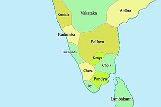
Kongu Nadu, also known by various names such as Kongu Mandalam and Kongu belt, is a geographical region comprising present day parts of western Tamil Nadu, southeastern Karnataka and eastern Kerala. In the ancient Tamilakam, it was the seat of the Chera kings, bounded on the east by Tondai Nadu, on the south-east by Chola Nadu and on the south by Pandya Nadu regions.

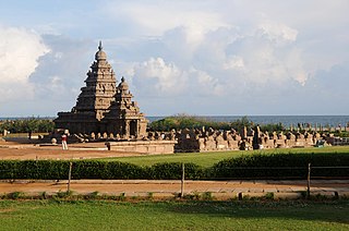
Chola Nadu is a cultural region of the Tamil Nadu state in southern India. It encompasses the lower reaches of the Kaveri River and its delta, and formed the cultural homeland and political base of the Chola Dynasty which ruled large parts of South India and parts of Sri Lanka between the 9th and 13th centuries CE. Uraiyur served as the early Chola capital, then medieval Cholas shifted to Thanjavur and later cholas king Rajendra Chola I moved the capital to Gangaikonda Cholapuram in Ariyalur in the 11th century CE.
Thoothukudi District is one of the 38 districts of Tamil Nadu state in southern India. The district was formed by bifurcation of Tirunelveli district on 20 October 1986. Thoothukudi is the district headquarters and largest city of the district. The district is known for fishing as well as pearl cultivation, with an abundance of pearls being found in the seas offshore. Thoothukudi district has many historical sites such as Adichanallur and the ancient trade port of Korkai.
Mullaperiyar DamIPA: [mulːɐpːeɾijɐːr], is a masonry gravity dam on the Periyar River in the Indian state of Kerala It is located 881 m (2,890 ft) above the sea level, on the Cardamom Hills of the Western Ghats in Thekkady, Idukki District of Kerala, India. It was constructed between 1887 and 1895 by John Pennycuick and also reached in an agreement to divert water eastwards to the Madras Presidency area. It has a height of 53.6 m (176 ft) from the foundation, and a length of 365.7 m (1,200 ft). The Periyar National Park in Thekkady is located around the dam's reservoir. The dam is built at the confluence of Mullayar and Periyar rivers. The dam is located in Kerala on the river Periyar, but is operated and maintained by the neighbouring state of Tamil Nadu. Although the Periyar River has a total catchment area of 5398 km2 with 114 km2 downstream from the dam in Tamil Nadu, the catchment area of the Mullaperiyar Dam itself lies entirely in Kerala and thus not an inter-State river. On 21 November 2014, the water level hit 142 feet for first time in 35 years. The reservoir again hit the maximum limit of 142 feet on 15 August 2018, following incessant rains in the state of Kerala. In a UN report published in 2021, the dam was identified as one among the world's big dams which needs to be decommissioned for being 'situated in a seismically active area with significant structural flaws and poses risk to 3.5 million people if the 100+ years old dam were to fail'.

Parambikulam Dam is an embankment dam on the Parambikulam River, Parambikulam located in the Palakkad district in the Western Ghats of Kerala, India, ranks number one in India as well as in the top ten embankment dams in the world in volume in the year 2000.

Veeranam Lake is located 14 km (8.7 mi) SSW in Cuddalore district in the state of Tamil Nadu in South India 1 km from Kattumannarkoil. It is located 235 km (146 mi) from Chennai, India. It is one of the water reservoirs from where water is supplied to Chennai city. The lake has a capacity to store about 1,465 mcft of water. Though the level in the Veeranam lake has dipped to 323 million cubic feet (mcft), the same amount of 180 mld was being drawn for city supply.
The Western Coastal Plains is a strip of coastal plain 50 kilometres in width between the west coast of India and the Western Ghats hills, which starts near the south of the Tapi River. The plains are located between the Western Ghats and the Arabian Sea. The plains begin at Gujarat in the north and end at Tamil Nadu in the south. It includes the states of Gujarat, Maharashtra, Goa, Karnataka, Kerala, and Tamil Nadu. The region consists of three sections: the Northern part of the coast is called the Konkan, the central stretch is called the Kanara or the "Karavali", while the southern stretch is referred to as the Malabar Coast. On its northern side there are two gulfs: the Gulf of Khambat and the Gulf of Kutch. The rivers along the coast form estuaries and provide conditions ideal for pisciculture. Because of the presence of less coastal land in this part, it will be affected more by the global warming.

Thanjavur district is one of the 38 districts of the state of Tamil Nadu, in southeastern India. Its headquarters is Thanjavur. The district is located in the delta of the Cauvery River and is mostly agrarian. As of 2011, Thanjavur district had a population of 2,405,890 with a sex-ratio of 1,035 females for every 1,000 males.
Madurantakam taluk is a taluk of Chengalpattu district of the Indian state of Tamil Nadu. The headquarters of the taluk is the town of Madurantakam. Madurantakam taluk is bounded by Chengalpattu taluk in north, Uthiramerur taluk of Kanchipuram district in West, Thirukklaukkundram Taluk in north east and Tindivanam lauk of Villupuram district in south.
Aiyaru is a river flowing in the Namakkal district of the Indian state of Tamil Nadu.
Thirumalairajan is a river flowing in the Thanjavur, Tiruvarur and Nagapattinam districts of the Indian state of Tamil Nadu and Karaikal district of Puducherry. The river splits from Kudamurutti, a tributary of Kaveri river at Rajagiri near Papanasam, Thanjavur district. The river enters Bay of Bengal at Tirumalarajanpattinam near Karaikal.The river has a 150 years old bridge built by a king, who ruled the nearby places of the river.The bridge is also named after the river, the thirumalairajan river bridge.
Kundha is a river flowing in the Erode district of the Indian state of Tamil Nadu.
The Koraiyar River is a river in the Ambasamudram taluk of the Tirunelveli district of the Indian state of Tamil Nadu. It is a right-bank tributary of the Thamirabarani River, which flows through Tirunelveli and Thoothukudi districts. It is formed by the confluence of the minor Vadakkur Koraiyar and Therkku Koraiyar rivers, which are its headwater streams, on the eastern slopes of the Western Ghats. It flows for a total length of 13.2 kilometres (8.2 mi) before flowing into the Kannadian channel near the village of Vellankuli upstream of the Kannadian anicut. The channel bypasses the anicut before joining the Thamirabarani downstream and to the east of the dam. Along its course it is joined by three tributaries, the Vandal Odai, Elumichaiyar, and Koppuraiyar rivers. The Koraiyar's drainage basin covers an area of 75.75 square kilometres (29.25 sq mi) and has a recorded maximum flood discharge of 12000 cusecs.
Mullaiyar is a river flowing in the Tiruvarur district of the Indian state of Tamil Nadu. It is a tributary of the Kaveri river, and flows into the Bay of Bengal.

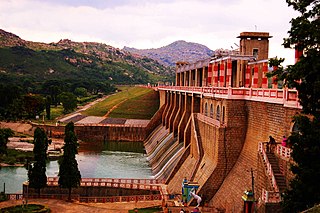
Kodiveri Dam is located on the Bhavani river near Sathyamangalam in Tamil Nadu. The dam is situated along the State Highway 15 about 15 km (9.3 mi) from Gobichettipalayam towards Sathyamangalam. From Sathyamangalam via Aalatthukombai the dam is at a distance of 7 km (4.3 mi).
References
- ↑ "SECTION 1 Title 1 Title 2 Title 3". Archived from the original on 28 September 2011. Retrieved 30 July 2015.