
The Coos River flows for about 5 miles (8.0 km) into Coos Bay along the Pacific coast of southwest Oregon in the United States. Formed by the confluence of its major tributaries, the South Fork Coos River and the Millicoma River, it drains an important timber-producing region of the Southern Oregon Coast Range. The course of the main stem and the major tributaries is generally westward from the coastal forests to the eastern end of Coos Bay near the city of Coos Bay.

Penna is a river of southern India. This is a unique river in world where after originating from Nandi hills, it flows as two different streams, one in North and South directions. The Penna rises in the Nandi Hills in Chikkaballapur District of Karnataka state, and runs north and east through the states of Karnataka and Andhra Pradesh to empty into bay of bengal in Andhra Pradesh. It is 597 kilometres (371 mi) long, with a drainage basin covering 55,213 km2: 6,937 km2 in Karnataka and 48,276 km2 in Andhra Pradesh. Along with this main stream there is another stream south towards Tamilnadu with the name Then Pennai or south Pennar which further moves towards the east to empty into the Bay of Bengal.The Penna river basin lies in the rain shadow region of Eastern Ghats and receives 500 mm average rainfall annually.

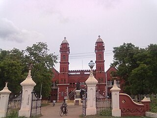
Pudukkottai is the administrative headquarters of Pudukkottai District in the Indian state of Tamil Nadu. It is a city located on the banks of the Vellar River. It has been ruled, at different times, by the mutharaiyar dynasty, Cholas, Early Pandyas, Thondaimans, and the British. It is situated about 395 kilometres (245 mi) southwest of the state capital Chennai and about 55 kilometres (34 mi) southeast of Tiruchirappalli. Tamil Nadu's first woman Asian Games competitor, Santhi Soundarajan, is from Pudukkottai.

Bharathidasan University (BDU) is a university in the city of Tiruchirappalli, Tamil Nadu, India. It is located on Tiruchirappalli-Pudukkottai National Highway 336. It has affiliated colleges in the districts of Ariyalur district, Karur, Nagapattinam, Perambalur, Pudukkottai, Thanjavur, Tiruvarur and Tiruchirapalli. It is a recognised university, supported by the University Grants Commission of India. All major faculties of science and arts are represented. The university has totally 4 Faculties, 16 Schools, 37 Departments and 29 Specialized Research Centres.

Tiruchirappalli District is one of the 38 districts, located along the Kaveri River, in Tamil Nadu, India. The headquarters of the district is the city of Tiruchirappalli.
Pudukkottai District is one of the 38 districts of Tamil Nadu state in southern India. The city of Pudukkottai is the district headquarters. It is also known colloquially as Pudhugai.
Aranthangi is a town in Pudukkottai district in the state of Tamil Nadu, India. As of 2011, it had a population of 40,814.

Thailand has 22 river basins with 254 sub-basins. Rainwater is one of the most important sources of water. Thailand's water resource per capita is less than that of other countries in the region.
The Arghistan or Arghastan is a river in southern Afghanistan. It flows through Arghistan District and the provinces of Zabul and Kandahar. It is a tributary of the Dori River, a sub-tributary of the Helmand River. It flows for 280 kilometres (170 mi) and has a basin area of 20,219 square kilometres (7,807 sq mi).

The South Fork Eel River is the largest tributary of the Eel River in north-central California in the United States. The river flows 105 miles (169 km) north from Laytonville to Dyerville/Founders' Grove where it joins the Eel River. The South Fork drains a long and narrow portion of the Coast Range of California in parts of Mendocino and Humboldt counties. U.S. Route 101 follows the river for much of its length.
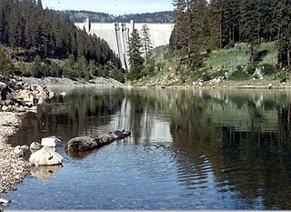
The North Fork Clearwater River is a major tributary of the Clearwater River in the U.S. state of Idaho. From its headwaters in the Bitterroot Mountains of eastern Idaho, it flows 135 miles (217 km) westward and is dammed by the Dworshak Dam just above its mouth in north-central Idaho. Draining a rugged watershed of 2,462 square miles (6,380 km2), the river has an average flow of over 5,600 cubic feet per second (160 m3/s), accounting for a third of the discharge from the Clearwater basin. The river drains parts of Clearwater, Shoshone, Latah, and Idaho counties. Most of the watershed is managed by the U.S. Forest Service. Some of the fish of the river include westslope cutthroat trout, rainbow trout, mountain whitefish, and the threatened bull trout. It also has smallmouth bass and a kokanee salmon run, both from Dworshak Reservoir. The North Fork drainage is home to grizzly bears, cougars, deer, moose, black bear, elk, grey wolves, and osprey. The river used to have a large steelhead run before the implementation of Dworshak Dam. The North Fork of the Clearwater is located within the Clearwater National Forest

The Vellar River is a river in the Indian state of Tamil Nadu. It originates in the Kalrayan Hills, and flows generally eastward through Salem, Perambalur, and Cuddalore districts, before flowing into the Bay of Bengal near Parangipettai. The river has a total length of 150 kilometres (93 mi), and its drainage basin covers an area of 7,504.346 square kilometres (2,897.444 sq mi) in Cuddalore, Perambalur, Salem, Kallakurichi, Ariyalur, Namakkal, Tiruchirappalli, and Dharmapuri districts.
The Steinlach is a river with a length of 26 km (16 mi) in Baden-Württemberg, Germany. It is a tributary to the Neckar.

Thuvarankurichi is a town in Tiruchirappalli district in the Chola Nadu region of the Indian state of Tamil Nadu. It is situated 65 kilometers away from both Tiruchirappalli and Madurai. The town is located within the drainage basin of the Vellar River Raja college of Allied Health Science and Hotel Management College located at Thuvarankurichi.

Abrahams Creek is a tributary of the Susquehanna River in Luzerne County, Pennsylvania, in the United States. It is approximately 10.7 miles (17.2 km) long and flows through Franklin Township, Dallas Township, Kingston Township, West Wyoming, Wyoming, and Forty Fort. The watershed of the creek has an area of 17.4 square miles (45 km2) and occupies portions of nine municipalities in northeastern Luzerne County. The watershed is divided into the upper Abraham Creek watershed and the lower Abraham Creek watershed, which are joined by a canyon known as The Hollow. The upper part of the watershed is mostly rural, but the lower part is heavily urbanized. The creek's channel has been heavily modified in many places. Its drainage basin is designated as a Coldwater Fishery and a Migratory Fishery.
The Agniyar River is a non-perennial river in the Indian state of Tamil Nadu that flows southeast into the Bay of Bengal.

The Ambuliyar or Ambuli River is a non-perennial river in the Pudukkottai and Thanjavur districts of Tamil Nadu, India, that flows southeast into the Palk Strait.
Kurichi is a village in the Vazhapadi taluk of Salem district, in Tamil Nadu, India.

The Bravone is a small coastal river in the department of Haute-Corse, Corsica, France.
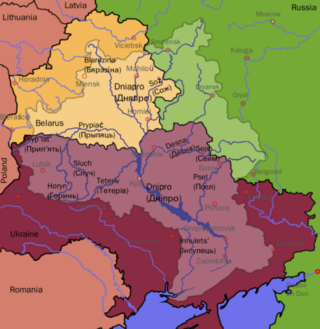
The Dnieper Basin is the drainage basin of the Dnieper River, covering an area of 531,817 square kilometres (205,336 sq mi). Its water resources compose around 80% of the total for all Ukraine.
