Tiruchirappalli district

Last updated

Tiruchirappalli District
Trichy District
Ranganathaswamy temple tiruchirappalli.jpg
Upper Anaicut.JPG
Mutharasanallur1.jpg
River kaveri in musiri,tamilnadu.jpg
My city Rockfort.5.jpg
Clockwise from top-left: Ranganathaswamy Temple in Srirangam, Upper Anaicut, Kaveri in Musiri, view of Tiruchirappalli from Rockfort, ponds in Mutharasanallur
Tiruchirappalli in Tamil Nadu (India).svg
Location in Tamil Nadu
Tiruchirappalli district
Thiruchirappalli district
Coordinates: 10°47′N78°41′E / 10.783°N 78.683°E / 10.783; 78.683
CountryFlag of India.svg  India
State TamilNadu Logo.svg Tamil Nadu
Municipal corporations Tiruchirappalli
Municipalities Thuraiyur, Manapparai, Thuvakudi, Lalgudi, Musiri
Town panchayats [1] Balakrishnampatti, Kallakudi, Kattuputhur, Koothappar, Manachanallur, Mettupalayam, Ponnampatti, Poovalur, Pullambadi, South Kannanur, Sirugamani, Thathaiyangarpet, Thottiyam, Uppiliapuram
divisions Tiruchirappalli division, Lalgudi division, Musiri division, Srirangam division
Headquarters Tiruchirapalli
Talukas Lalgudi taluk, Manachanallur taluk, Manapparai taluk, Marungapuri taluk, Musiri taluk, Srirangam taluk, Thiruverumbur taluk, Thottiyam taluk, Thuraiyur taluk, Tiruchirappalli West taluk, Tiruchirappalli East taluk
Government
  CollectorM. Pradeep Kumar, IAS [2]
  Superintendent of PoliceVarun Kumar, IPS [3]
  Assistant CollectorJ. E. Padmaja, IAS [4]
Area
  Total4,403.83 km2 (1,700.33 sq mi)
  Rank10th
Elevation
88 m (289 ft)
Population
 (2011)
  Total2,722,290
  Rank6th
  Density620/km2 (1,600/sq mi)
Languages
  Official Tamil
Time zone UTC+5:30 (IST)
PIN
620 xxx and 621 xxx
Telephone code0431
ISO 3166 code [[ISO 3166-2:IN|]]
Vehicle registration TN-45, TN-48, TN-81 [5]
Central location: 10°47′N78°41′E / 10.783°N 78.683°E / 10.783; 78.683
Website tiruchirappalli.nic.in

Tiruchirappalli District is one of the 38 districts, located along the Kaveri River, in Tamil Nadu, India. The headquarters of the district is the city of Tiruchirappalli.

Contents

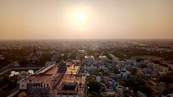
During the British Raj, the district was referred to as Trichinopoly, and was a district of the Madras Presidency; it was renamed upon India's declaration of independence in 1947. The district is spread over an area of 4,404 square kilometres (1,700 sq mi) and had a population of 2,722,290 in 2011.

Geography

Kaveri river and Rockfort at Tiruchirapalli Trichy11.jpg
Kaveri river and Rockfort at Tiruchirapalli

Tiruchirappalli district lies almost at the exact centre of Tamil Nadu. The district has an area of 4,404 square kilometres. It is bounded in the north by Salem district, Northwest by Namakkal district, in the Northeast by Perambalur District, East by Ariyalur district and Thanjavur District, in the southeast by Pudukkottai district and Sivagangai district, in the south by Madurai district, in the southwest by Dindigul district and, in the west by Karur district. The district shares its borders with 10 other districts, the highest for any district in the state. The Kaveri river flows through the length of the district and is the principal source of irrigation and drinking water.[ citation needed ]

Kolli Hills form the boundary of Tiruchirapalli and Namakkal districts and Pachaimalai Hills form the Boundary of Salem and Perambalur district with Tiruchirapalli district in the North and North East.[ citation needed ]

The North most and South most parts of the district are hilly, central part of the district is Kaveri plains. Trichy district is diverse in landscape, mixture of Fertile, Delta, Valleys, Hilly areas, Semi Arid Zones. Central part of the district is fertile due to river Kaveri flowing through this district, by splitting the district into North and South. North Central and South Central part of the district is Semi arid and drought prone area, receives less rainfall. Evergreen Pachaimalai Hills and Kolli Hills form the Stunning and Enchanting Valley in between these two hills. Falls and Streams from these two hills fills up the lakes in valley areas and makes the land irrigated and Fertile.

Pachaimalai Hills receives high rain fall than average during both Northeast Monsoon as well as Southwest Monsoon, which makes these hills Greener throughout the year and gives a cool climate.[ citation needed ]

Demographics

Historical population
YearPop.±% p.a.
1901807,320    
1911876,070+0.82%
1921912,177+0.40%
1931918,342+0.07%
YearPop.±% p.a.
19411,035,927+1.21%
19511,184,158+1.35%
19611,304,039+0.97%
19711,650,768+2.39%
YearPop.±% p.a.
19811,900,566+1.42%
19912,196,473+1.46%
20012,418,366+0.97%
20112,722,290+1.19%
source: [6]

According to 2011 census, Tiruchirappalli district had a population of 2,722,290 with a sex-ratio of 1,013 females for every 1,000 males, much above the national average of 929. 49.15% of the population lives in urban areas. [7] A total of 272,456 were under the age of six, constituting 139,946 males and 132,510 females. Scheduled Castes and Scheduled Tribes accounted for 17.14% and 0.67% of the population respectively. The average literacy of the district was 74.9%, compared to the national average of 72.99%. [7] The district had a total of 698,404 households. There were a total of 1,213,979 workers, comprising 161,657 cultivators, 319,720 main agricultural labourers, 25,174 in house hold industries, 575,778 other workers, 131,650 marginal workers, 9,012 marginal cultivators, 59,062 marginal agricultural labourers, 5,212 marginal workers in household industries and 58,364 other marginal workers. [8]

Religions in Tiruchirappalli district (2011) [9]
ReligionPercent
Hinduism
83.73%
Christianity
9.04%
Islam
7.01%
Other or not stated
0.22%

Languages of Tiruchirappalli district (2011) [10]

   Tamil (95.67%)
   Telugu (2.08%)
   Urdu (1.10%)
  Others (1.15%)

At the time of the 2011 census, 95.67% of the population spoke Tamil, 2.08% Telugu and 1.10% Urdu as their first language. [10]

Politics

DistrictNo.ConstituencyNamePartyAllianceRemarks
Tiruchirappalli 138 Manapaarai Abdul Samad. P Dravida Munnetra Kazhagam (MMK) SPA
139 Srirangam M. Palaniyandi Dravida Munnetra Kazhagam SPA
140 Tiruchirappalli (West) K. N. Nehru Dravida Munnetra Kazhagam SPA
141 Tiruchirappalli (East) Inigo Irudhayaraj .S Dravida Munnetra Kazhagam SPA
142 Thiruverumbur Anbil Mahesh Poyyamozhi Dravida Munnetra Kazhagam SPA
143 Lalgudi A. Soundara Pandian Dravida Munnetra Kazhagam SPA
144 Manachanallur C. Kathiravan Dravida Munnetra Kazhagam SPA
145 Musiri N. Thiyagarajan Dravida Munnetra Kazhagam SPA
146 Thuraiyur (SC) S. Stalin Kumar Dravida Munnetra Kazhagam SPA

Taluks

Srirangam Temple Gopuram Srirangam Temple Gopuram (767010404).jpg
Srirangam Temple Gopuram

In 2013, Tiruchirappalli district went from nine taluks to eleven taluks. [11]

Urban centres

Thiruvanaikaval Temple at Tiruchirapalli Tvkoil.JPG
Thiruvanaikaval Temple at Tiruchirapalli

Tiruchirappalli District consists of the following urban centres:

Headquarters of Tiruchirappalli City Municipal Corporation Trichycorporation.jpg
Headquarters of Tiruchirappalli City Municipal Corporation

Major industries

Natural resources and water bodies

Upper Anaicut or Mukkombu Trichii02.JPG
Upper Anaicut or Mukkombu

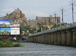
The major rivers are the River Kaveri and the River Kollidam. The important rivers across city is Koraiyar, Uyyakondan and Kudamuruti rivers.[ citation needed ]

Agriculture

The district has a large cattle and poultry population with agriculture workers in the smaller villages like Kalpalayathanpatti.

The rivers Kaveri and Kollidam start branching out to form the Kaveri delta irrigating vast tracts of land in the district. The major crops are rice (vast tracts); sugarcane (vast tracts); banana/plantain; coconut; cotton (small tracts); betel; maize; and groundnut.

Trichirapalli district is well known for all varieties of Banana Cultivation. Banana research centre is located in Tiruchirapalli Agricultural University. National Research Centre for Banana, ICAR NRB is also located in Trichy.


Tiruchirapalli district is well known for Sugarcane Plantation also, Agriculture Research Centre for Sugarcane is located in Sirugamani.

Coffee, Hill Jackfruit, Cassava, mountain crops are grown in the Pachaimalai Hills of Tiruchirapalli district.

Divya Desam Temples

The first five divya desam temples are located in tiruchirappalli district.

  1. Srirangam Ranganathaswamy Temple (1st Divya Desam)
  2. Azhagiya Manavala Perumal Temple (2nd Divya Desam)
  3. Uthamar Kovil (3rd Divya Desam)
  4. Pundarikakshan Perumal Temple (4th Divya Desam)
  5. Sundararaja Perumal temple (5th Divya Desam)

Related Research Articles

<span class="mw-page-title-main">Srirangam</span> Region of Tiruchirappalli, Tamil Nadu

Srirangam is a neighbourhood in the city of Tiruchirappalli in the Indian state of Tamil Nadu. A river island, Srirangam is bounded by the Kaveri River on one side and its distributary Kollidam on the other side. Considered as the first among the 108 Divya Desams, a group of Vishnu temples, it is famous for the Sri Ranganathaswamy Temple, the largest temple complex in India and the biggest functioning Hindu temple in the world. Srirangam is also home to a significant population of Sri Vaishnavas.

<span class="mw-page-title-main">Namakkal</span> Town in Tamil Nadu, India

Namakkal is a special grade municipality and the headquarters of Namakkal district in the Indian state of Tamil Nadu. It is the first ISO 14001-2004 certified municipality in Asia for environmental management, specifically the provision and maintenance of water supply, solid waste and sewage management, town planning, lighting and other social services. Namakkal is known as the Egg City due to its large egg production and Transport city.

<span class="mw-page-title-main">Aruppukkottai</span> Town in Tamil Nadu, India

Aruppukottai is a town and a municipality in Virudhunagar district in the state of Tamil Nadu, India. Aruppukottai's classical name is "Sengattu Aravakotai". Aruppukottai is about 50 km from Madurai. It is in the middle of Madurai-Tuticorin National Highways NH-38. The villages and towns surrounding Aruppukottai makes this as a major town as well as a major transit hub and they are also famous for production of jasmine. Aruppukottai is always famous for producing yarn. Sri Ramana Maharishi was born in Tiruchuli near Aruppukottai town. Aruppukottai was part of king Sethupathi of Ramnad. King Sethupathi has Zamin Palace in Palyampatti. As of 2011, the town had a population of 87,722. The town also hosts two famous temples – Arulmigu Meenakshi Chokkanatha Swamy Temple built in 13th century by Pandiya King Maravarma Sundarapandiyan and Seenivasa Perumal Temple Built on the top of Malai arasan Hill.

<span class="mw-page-title-main">Perambalur district</span> District of Tamil Nadu in India

Perambalur is one of the 38 districts in the state of Tamil Nadu, India. The district headquarters is located at Perambalur. The district occupies an area of 1,752 km2 and had a population of 565,223 with a sex-ratio of 1,003 females for every 1,000 males in 2011.

<span class="mw-page-title-main">Madurai district</span> District in Tamil Nadu, India

Madurai district is one of the 38 districts of the state of Tamil Nadu in southeastern India. The city of Madurai serves as the district headquarters. It houses the famous Sri Meenakshi Sundareshwarar temple and is situated on the banks of the river Vaigai. Thiruparankundram is one of the major tourist place in the district. As of 2011, the district had a population of 3,038,252 with a sex-ratio of 990 females for every 1,000 males. Aside from the city of Madurai, the larger towns are Melur, Vadipatti, Thirumangalam, Thirupparankundram, Peraiyur, and Usilampatti. It is an important hub for various film shootings. Alanganallur is a popular spot in the district for Jallikattu, as are Palamedu and Avaniyapuram.

<span class="mw-page-title-main">Palani</span> Town in Tamil Nadu, India

Palani (Tamil:[paɻani] or Palnias in British records, is a town and a taluk headquarters in Dindigul district of the western part of Tamil Nadu state in India. It is located about 106 kilometres south-east of Coimbatore and 122 kilometres north-west of Madurai, 67 kilometres from Kodaikanal. The Palani Murugan Temple or Arulmigu Dhandayuthapani Swamy Temple, dedicated to Murugan is situated on a hill overlooking the town. The temple is visited by more than 7 million pilgrims each year. As of 2011, the town had a population of 292301 which makes it the second largest town in the district after Dindigul.

<span class="mw-page-title-main">Karur district</span> District of Tamil Nadu in India

Karur District is one of the 38 districts in the Indian state of Tamil Nadu. The main town in Karur District is the city of Karur, which is also the district headquarters. The district has a population of 1,064,493 with a sex-ratio of 1,015 females for every 1,000 males, according to 2011 census.

<span class="mw-page-title-main">Dharmapuri district</span> Place in India

Dharmapuri is one of the 38 districts in the state of Tamil-Nadu, India. It is the first district created in Tamil Nadu after the independence of India by splitting it from then-Salem district on 2 October 1965. Dharmapuri District is one of the major producers of mango in the state, fine quality granite is found in the district. It is also one of the main sericulture belts in the state. Around 30 percent of the district's area is under forest cover. Kaveri enters Tamil Nadu through this district. Dharmapuri district had the lowest literacy rate of 74.23% in Tamilnadu during the 2011 census.

Kattuputhur is a Panchayat town in the Thottiyam taluk Tiruchirappalli district of the Indian state of Tamil Nadu. The town sits at an altitude of 102 metres (335 ft).

Musiri is a municipality and Taluk in the Tiruchirappalli district in the Indian state of Tamil Nadu. It has an average elevation of 82 metres (269 feet).

<span class="mw-page-title-main">Thuraiyur</span> Municipality in Tamil Nadu, India

Thuraiyur is a town and a municipality in the Tiruchirappalli district in the Indian state of Tamil Nadu. It was upgraded to a III Grade Municipality from Town Panchayat on 17 January 1970, and to a II Grade Municipality in May 1998. It was upgraded to Selection Grade Municipality in the year 2008. It is also a taluka. It is located 310 km away from Chennai.

Muttharasanallur is a village in Tiruchirapalli in the state of Tamil Nadu, India. It is located approximately 7 km to the west of Trichy City on the road to the town of Karur. Mutharasanallur is a main agricultural village with water source from the River Kaveri.

The Pachaimalai Hills,, also known as the Pachais, are a low mountain range in the Eastern Ghats System. They are located in Tiruchirapalli district of Tamil Nadu state, southeastern India. It is situated at a distance of 73 km from Trichy and 112 km from Salem. The Tamil Nadu Government is planning to develop the Pachaimalai as a tourist destination.

<span class="mw-page-title-main">Sendamangalam</span> Town in Tamil Nadu, India

Sendamangalam also known as Senthamangalam Taluka is a Town and Municipality in the Indian state of Tamil Nadu is situated in Namakkal District.

Pettavaithalai is a panchayat town in Srirangam taluk Tiruchirappalli district in the Indian state of Tamil Nadu.

<span class="mw-page-title-main">Geography of Tiruchirappalli</span>

Tiruchirappalli (Tamil: திருச்சிராப்பள்ளி, also called Tiruchi or Trichy, is a city in the Indian state of Tamil Nadu and the administrative headquarters of Tiruchirapalli District. It is the fourth largest municipal corporation in Tamil Nadu and also the fourth largest urban agglomeration in the state. It is located almost at the geographic centre of the state.

Nagamangalam is a village in the Srirangam taluk of Tiruchirappalli district in Tamil Nadu, India. It is located at 14 km from Central Bus stand and equally distant from Tiruchirapalli Railway junction. Nagamangalam is situated in Trichy - Madurai road and is a rapidly developing residential area. Being located next to Panjapur and Manikandam it has ample greenary and pollution free atmosphere.

Tiruchirappalli is a city in the Indian state of Tamil Nadu. It is the fourth most populous city and is the densest regional urban area in the state. According to the 2001 census, Tiruchirappalli had a population of 752,066 with in the city limits and an extended urban agglomeration population of 866,354. According to the 2011 census, Tiruchirappalli had a population of 847,387 within the city limits The city's sex ratio of 1025 is among the best for any city in India which has a population of one million or more.

<span class="mw-page-title-main">Kallakurichi district</span> District of Tamil Nadu in India

Kallakurichi is one of the 38 districts in the state of Tamil Nadu in India. The district headquarter is Kallakurichi. Kallakurichi District was announced on 8 January 2019 and it came into existence on 26 November 2019.

<span class="mw-page-title-main">Sendamangalam taluk</span> Taluk in Tamil Nadu, India

Sendamangalam is a Taluk in the Indian state of Tamil Nadu is situated in Namakkal District.

References

  1. "List of Town Panchayats" (PDF). Commissionerate of Town Panchayats. National Informatics Centre. pp. 12–13. Retrieved 5 February 2022.
  2. "Will focus on agriculture, health and education, says new Tiruchi Collector". The Hindu. 16 June 2022.
  3. "New Tiruchi SP takes charge". The Hindu. 19 November 2021.
  4. "District Administration | Tamil Nadu Government Portal".
  5. www.tn.gov.in
  6. Decadal Variation In Population Since 1901
  7. 1 2 "Census Info 2011 Final population totals". Office of The Registrar General and Census Commissioner, Ministry of Home Affairs, Government of India. 2013. Retrieved 26 January 2014.
  8. "Census Info 2011 Final population totals - Tiruchirappalli district". Office of The Registrar General and Census Commissioner, Ministry of Home Affairs, Government of India. 2013. Retrieved 26 January 2014.
  9. "Table C-01 Population by Religion: Tamil Nadu". censusindia.gov.in. Registrar General and Census Commissioner of India. 2011.
  10. 1 2 "Table C-16 Population by Mother Tongue: Tamil Nadu". Census of India . Registrar General and Census Commissioner of India.
  11. "Residents question move to locate Marungapuri taluk office at Kallupatti". The Hindu . 21 June 2013.