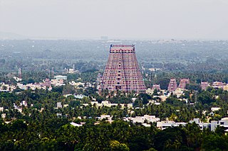
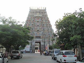
Srirangam is a neighbourhood in the city of Tiruchirappalli in the Indian state of Tamil Nadu. A river island, Srirangam is bounded by the Kaveri River on one side and its distributary Kollidam on the other side. Considered as the first among the 108 Divya Desams, a group of Vishnu temples, it is famous for the Sri Ranganathaswamy Temple, the largest temple complex in India and the biggest functioning Hindu temple in the world. Srirangam is also home to a significant population of Sri Vaishnavas.

Perambalur is one of the 38 districts in the state of Tamil Nadu, India. The district headquarters is located at Perambalur. The district occupies an area of 1,752 km2 and had a population of 565,223 with a sex-ratio of 1,003 females for every 1,000 males in 2011.

Tiruchirappalli District is one of the 38 districts, located along the Kaveri River, in Tamil Nadu, India. The headquarters of the district is the city of Tiruchirappalli.
Karur District is one of the 38 districts in the Indian state of Tamil Nadu. The main town in Karur District is the city of Karur, which is also the district headquarters. The district has a population of 1,064,493 with a sex-ratio of 1,015 females for every 1,000 males, according to 2011 census.
Pudukkottai District is one of the 38 districts of Tamil Nadu state in southern India. The city of Pudukkottai is the district headquarters. It is also known colloquially as Pudhugai.
Musiri is a municipality and Taluk in the Tiruchirappalli district in the Indian state of Tamil Nadu. It has an average elevation of 82 metres (269 feet).
Tiruchirapalli West Taluk is a taluk of Tiruchirapalli district of the Indian state of Tamil Nadu. It was formed in 2013 when the Tiruchirappalli taluk was bifurcated into Tiruchirappalli East and Tiruchirappalli West. Wards 39 to 42 and 44 to 60 fall under the jurisdiction of the Taluk.

Thungapuram is a panchayat village of Perambalur district, Tamil Nadu, India. It was formerly in Tiruchirappalli district
The Trichinopoly district was a district of the erstwhile Madras Presidency of British India. It covered the present-day districts of Tiruchirappalli, Karur, Ariyalur and Perambalur in the Indian state of Tamil Nadu. The administrative headquarters was the town of Trichinopoly, Trichy or Tiruchi, now known as Tiruchirappalli. The district covered an area of 2,632 square miles (6,820 km2) in 1907. It was bound by the districts of South Arcot to the north, Salem to the west, Coimbatore to the west and north-west, Tanjore to the east and Madurai to the south. The princely state of Pudukkottai remained within the jurisdiction of Trichinopoly district from 1865 to 1947.
Konalai is a village in Manachanallur Taluk, Tiruchirappalli District, in the Indian state of Tamil Nadu. It is 67 meters above sea level with good road connections amidst a network of rivers and waterways north of the Kolladam River. The state capital of Chennai is 331 km northeast with the district headquarters of Tiruchirappalli 22 km to the south and Manachanallur Taluk 14 km southwest. The nearest major railway station to Konalai is in Tiruchirappalli.
Marungapuri block and Marungapuri Taluk is a revenue block and Taluk in the Tiruchirappalli district of Tamil Nadu, India. It has a total of 49 panchayat villages. Marungapuri taluk has Marungapuri, Thuvarankurichi and Valanadu firkas as its jurisdictional areas. The Taluk Office is functioning temporarily at T.Kallupatti, about three km away from Marungapuri, on the Tiruchi-Madurai National Highway. Marungapuri taluk caters to a population of about 1.41 lakh in an area of about 445 square km and the Manapparai taluk to about 2.63 lakh in 544.36 square km. The Taluk Comes Under The Jurisdiction of Srirangam Revenue Divisional Office (RDO).
Tiruchirappalli division is a revenue division in the Tiruchirapalli district of Tamil Nadu, India. It comprises the taluks of Tiruchirappalli West taluk, Tiruchirappalli East taluk, Thiruverumbur taluk.
Pirattiyur is a part of the city of Tiruchirappalli and located in Tiruchirappalli West taluk, Tiruchirappalli district, Tamil Nadu, India. A former Town Panchayat, which covers the whole of Edamalaipatti Pudur, it was merged with the Tiruchirappalli Corporation in 1994.
Alathur is a village in Tiruchirappalli taluk of Tiruchirappalli district, Tamil Nadu. It was merged with the Tiruchirappalli Corporation in 2011.
Ellakudy is a village in Tiruchirappalli taluk of Tiruchirappalli district, Tamil Nadu, India. It was merged with the Tiruchirappalli Corporation in 2011.
Kilakalkandarkottai is a village in Tiruchirappalli taluk of Tiruchirappalli district in Tamil Nadu, India. It was merged with the Tiruchirappalli Corporation in 2011.
Natarajapuram is a village in Tiruchirappalli taluk of Tiruchirappalli district in Tamil Nadu, India.
Kaiperambalur is a panchayat village of the Kizhamathdur district in Perambalur, Tamil Nadu, India. It was formally part of the Tiruchirappalli district.
C.Ayyampalayam is a village located in the Manachanallur taluk of the Tiruchirappalli district of the Indian state Tamil Nadu. It is situated 5 km away from taluk headquarter Manachanallur and 20 km away from district headquarter Tiruchirappalli.
