Tiruppur district

Last updated

Tiruppur District
Amaravathi statue, Dharapuram.jpg
Noyyal River in Tiruppur JEG0350.jpg
Tiruppur sugrisvara temple3.JPG
Amaravathi Dam and reservoir - panoramio (3).jpg
Clockwise from top-left: Sri Venkatesha Perumal Temple, Mondipalayam, Amaravathi statue in Dharapuram, Thiru Sugriswara Temple, Amaravathi Dam, Bridge over the Noyyal River in Tiruppur
Tiruppur in Tamil Nadu (India).svg
Location in Tamil Nadu
Tiruppur district
Tirupur district
Coordinates: 11°11′N77°15′E / 11.18°N 77.25°E / 11.18; 77.25
Country Flag of India.svg  India
State TamilNadu Logo.svg Tamil Nadu
Headquarters Tiruppur
Taluks Avinashi, Dharapuram, Kangeyam, Madathukulam, Palladam, Tiruppur North, Tiruppur South, Udumalaipettai, Uthukuli
Government
   District Collector Thiru Dr.S. Vineeth I.A.S
Population
 (2011)
  Total2,479,052
Languages
  Official Tamil
Time zone UTC+5:30 (IST)
Telephone code+91-0421
Vehicle registration TN-39,TN-39Z,TN-42,TN-42Y,TN-78,TN-78M
Website tiruppur.nic.in

Tiruppur District is one of the 38 districts of the Indian state of Tamil Nadu, formed in 22 February 2009. Dharapuram was the largest taluk by area in the district. The district is well-developed and industrialized. The Tiruppur banian industry, the cotton market, Kangeyam bull and Uthukkuli butter, among other things, provide for a vibrant economy. [1] The city of Tiruppur is the administrative headquarters for the district. As of 2011, the district had a population of 2,479,052 with a sex-ratio of 989 females for every 1,000 males.

Contents

History

The district is named after the city of Tiruppur. In Mahabaratha, Arjuna (the third of the Pandavas) returned the cattle captured by the enemies and returned to Dharapuram (நிறை மீட்டல், Nirai Meetal). It eventually become Nirai Thiruputhal and become Tiruppur.

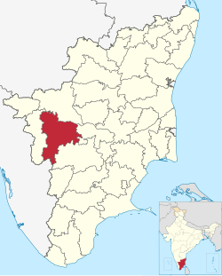
Since the 1990s, the formation of the new Tiruppur district had been urged by the exporters of Tiruppur. [2] Tiruppur city and surrounding region, where there is considerable industrial and business activities, was to be the core area. They believed that a new district would facilitate administration of the region and allow more aggressive development measures. [2] Tiruppur district was formed in 2009, carved out of the Coimbatore and Erode districts making it the 32nd district of Tamil Nadu [3] and one of the ten most industrialised and economically developed districts of Tamil Nadu. [2]

Before the formation of Tiruppur district, Avinashi, Madathukulam, Palladam, Tiruppur, and Udumalpet were taluks of Coimbatore district; and Dharapuram and Kangeyam were taluks of Erode district. [4] The new taluks of Madathukulam and Uthukuli were formed after the district was created. [5]

Geography and climate

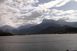
Tiruppur district lies on the western part of Tamil Nadu bordering the Western Ghats and hence the district enjoys a moderate climate. The district is surrounded by Coimbatore district in the west, Erode district to the North and northeast and Karur district in the east and Dindigul district in the south east. To the south the district is surrounded by Kerala state (Idukki district). The district has an area of 5187 sq.km. The southern and south western parts of the district (Dharapuram and Udumalpet) enjoys maximum rainfall, due to the surrounding of western ghats. The rest of the district lies in the rain shadow region of the Western Ghats and experiences salubrious climate most parts of the year, except the extreme east part of the district. The mean maximum and minimum temperatures for Tiruppur city during summer and winter vary between 35 °C to 18 °C. The average annual rainfall in the plains is around 700mm with the North East and the South West monsoons contributing to 47% and 28% respectively to the total rainfall. The major rivers flowing through the district are Noyyal and Amaravathi. The Amaravati river is the main source of irrigation in the district. Amaravathi Dam, which created Amaravathi Reservoir, is located at Amaravathinagar. Thirumurthy dam which is created by the PAP project is situated in this district. Both Amaravathi dam and Thirumurthy dam are the prime source of irrigation in the district, whereas Uppaar dam is another dam which receives water from seasonal rains.

Demographics

Historical population
YearPop.±% p.a.
1901516,618    
1911553,598+0.69%
1921588,291+0.61%
1931655,837+1.09%
1941754,273+1.41%
1951884,545+1.61%
1961949,859+0.71%
19711,130,940+1.76%
19811,324,480+1.59%
19911,531,983+1.47%
20011,920,154+2.28%
20112,479,052+2.59%
source: [6]
Religions in Tiruppur district (2011) [7]
ReligionPercent
Hinduism
91.92%
Islam
5.00%
Christianity
2.82%
Other or not stated
0.26%

According to 2011 census, Tiruppur district had a population of 2,479,052 with a sex-ratio of 989 females for every 1,000 males, much above the national average of 929. 61.35% of the population lived in urban areas. [8] A total of 241,351 were under the age of six, constituting 123,612 males and 117,739 females. Scheduled Castes and Scheduled Tribes accounted for 15.97% and 0.22% of the population respectively. The average literacy of the district was 71.02%, compared to the national average of 72.99%. [9] The district had a total of 712,210 households. There were a total of 1,266,137 workers, comprising 130,331 cultivators, 216,945 main agricultural labourers, 36,139 in house hold industries, 785,181 other workers, 97,541 marginal workers, 5,486 marginal cultivators, 29,388 marginal agricultural labourers, 4,849 marginal workers in household industries and 57,818 other marginal workers. [8]

Languages of Tiruppur district (2011) [10]

   Tamil (83.82%)
   Telugu (11.04%)
   Kannada (2.29%)
   Malayalam (1.19%)
   Urdu (0.93%)
  Others (0.73%)

At the time of the 2011 census, 83.82% of the population spoke Tamil, 11.04% Telugu, 2.29% Kannada, 1.19% Malayalam and 0.93% Urdu as their first language. [10]

Politics

Source: [11] [12]
DistrictNo.ConstituencyNamePartyAllianceRemarks
Tiruppur 101 Dharapuram N. Kayalvizhi Dravida Munnetra Kazhagam SPA
102 Kangayam M. P. Saminathan Dravida Munnetra Kazhagam SPA
Tiruppur 112 Avanashi (SC) P. Dhanapal All India Anna Dravida Munnetra Kazhagam None
113 Tiruppur (North) K. N. Vijayakumar All India Anna Dravida Munnetra Kazhagam None
114 Tiruppur (South) K. Selvaraj Dravida Munnetra Kazhagam SPA
115 Palladam M. S. M. Anandan All India Anna Dravida Munnetra Kazhagam None
Tiruppur 125 Udumalaipettai Udumalai K. Radhakrishnan All India Anna Dravida Munnetra Kazhagam None
126 Madathukulam C. Mahendran All India Anna Dravida Munnetra Kazhagam None

Administration and politics

Tiruppur district is administered by a collector, presently K. Vijaya Karthikeyan.

Revenue Divisions and Taluks

Tiruppur Revenue Division: Tiruppur North, Tiruppur South, Palladam, Avinashi, Uthukuli

Dharapuram Revenue Division: Dharapuram, Kangeyam

Udumalpet Revenue Division: Udumalpet, Madathukulam

Municipal corporations

Municipalities

Town Panchayats

Proposed Greater Tiruppur

Proposed Municipalities

Proposed Town Panchayats

Panchayat Unions / Blocks

Parliamentary constituencies

Assembly constituencies

Economy

The city of Tirupur, at the heart of the district, is a textile center. [13] The agricultural sector is predominantly small and has marginal farmers with land holdings of less than two hectares. [14]

See also

Related Research Articles

<span class="mw-page-title-main">Erode district</span> District of Tamil Nadu in India

Erode District is one of the 38 districts in the state of Tamil Nadu in India. It was the largest district by area in the state before the formation of Tirupur District in 2009. The headquarters of the district is Erode. It is divided into two revenue divisions, Erode and Gobichettipalayam, and is further subdivided into 10 taluks. Erode District was a part of Coimbatore District before its division into two on 17 September 1979. It covers an area of 5,722 square kilometres (2,209 sq mi), and as of 2011, had a population of 2,251,744.

<span class="mw-page-title-main">Sathyamangalam</span> Town in Tamil Nadu, India

Sathyamangalam is a town and municipality in Erode district in the Indian state of Tamil Nadu. It lies on the banks of the Bhavani river, a tributary of the Cauvery in the foothills of the Western Ghats and is the headquarters of Sathyamangalam taluk. It is about 65 km from Erode, 58 km from Tiruppur and 65 km from Coimbatore. As of 2011, the town had a population of 37,816.

<span class="mw-page-title-main">Dharapuram</span> Historical town in Tamil Nadu, India

Dharapuram is a town situated along the banks of Amaravati River in Tiruppur district in the Indian state of Tamil Nadu. Dharapuram is one of the oldest towns in South India and was the capital of Kongu Nadu under the Cheras, Western Ganga Dynasty and later Kongu Cholas, at which time it was known as Viradapuram. Amaravathi River flows through the town. As of 2011, the town had a population of 67,007. The city houses famous temples including Agatheeswarar Temple, Kaadu Hanumanthasamy temple and many others.

<span class="mw-page-title-main">Kangeyam</span> Historical Town in India

Kangeyam is a historical town and municipality in Kangeyam Taluk of Tiruppur district in the Indian state of Tamil Nadu. It is situated on National Highway 81. Kangeyam is an economic center in Tamil Nadu. The main commercial interests of the municipality are rice hulling, coconut oil extraction, ghee production, and groundnut cultivation. The town is located 28 km from the district headquarters at Tiruppur, 45 km from the city of Erode, 70 km from the industrial town of Coimbatore,30 km from the town of Dharapuram, 55 km from the city of Karur, 140 km from the Ancient city of Trichy and 441 km from the state capital Chennai.

Mulanur is a panchayat town under in Dharapuram taluk in Tirupur District in the Indian state of Tamil Nadu.

<span class="mw-page-title-main">Muthur</span> Town in Tamil Nadu, India

Muthur is a panchayat town in Vellakovil block which comes under Kangeyam taluk in Tirupur district, Tamil Nadu, India.

<span class="mw-page-title-main">Udumalaipettai</span> Town in Tamil Nadu, India

Udumalai, also known as Udumalaipettai and Udumalpet, is a town in Tiruppur district in the Indian state of Tamil Nadu. It is located 535 km south west from the state capital, Chennai and 72 km from Coimbatore. It is the headquarters of Udumalaipettai taluk and had a population of 61,133 as per 2011 Census of India. The town comes under the Udumalaipettai Assembly constituency.

<span class="mw-page-title-main">Valparai</span> Town in Tamil Nadu, India

Valparai is a Taluk and hill station in the Coimbatore district of Tamil Nadu, India. It consists of Anamalai Tiger Reserve. It is located 3,474 feet (1,059 m) above sea level on the Anaimalai Hills range of the Western Ghats. There are a total of 56 estates here. The game of football is very popular here. State level competitions are held every year. The foothill starts exactly from Monkey Falls which is at a distance of 38 kilometres (24 mi) to Valparai. The route to Valparai from the foothills consists of 40 hairpin bends. The Kerala state border town of Malakkappara is at a distance of 27 kilometres from Valparai. While major portions of the land are owned by private tea companies, large forest areas continue to be out of bounds.

Vellakovil is a municipal town in Kangeyam taluk of Tirupur District, in the Indian state of Tamil Nadu. It is located on National Highway 81 between Trichy and Coimbatore. The town is spread in an area of 64.75 km2. As of 2011, the town had a population of 40,359. Kannapuram village located near to this town is famous for Kangeyam breed cattle market that happens on every year during Mariyamman temple festival in the month of April. It is an industrialized town with traditional agriculture being the occupation for most of the people. It holds lot of Power looms weaving bedsheets, floor mats and cotton materials being exported to foreign countries via exporters present in Karur.

Punjai Puliampatti is a municipality in the Erode district of Tamil Nadu, India.

Perumanallur is a textile Industrial city situated near Tirupur, Tamil Nadu, India. Coimbatore city on the National Highway which now bypasses outside the town. It is a cross junction in NH-47 connecting Cochin/Coimbatore with Erode/Salem and Tirupur with Gobichettipalayam.

Dharapuram taluk is a taluk in Tirupur district of the Indian state of Tamil Nadu. The headquarters is the town of Dharapuram. Dharapuram taluk previously included what is now Kangeyam taluk.

<span class="mw-page-title-main">Coimbatore District (Madras Presidency)</span>

Coimbatore District was one of the districts of the erstwhile Madras Presidency of British India. It covered the areas of the present-day districts of Coimbatore, Erode and Tirupur and the Kollegal taluk of present-day Karnataka. It covered a total area of 20,400 square kilometres (7,860 sq mi) and was sub-divided into 10 taluks. The administrative headquarters was Coimbatore city. Most of Coimbatore's inhabitants were Tamil-speaking but there were also large numbers of Malayalam, Telugu and Kannada speaking people.

Dharapuram division or Dharapuram sub-district is a revenue division in the Tiruppur district of Tamil Nadu, India. It is One Of The Three Revenue Divisions of Tiruppur district Other Two are Tiruppur and Udumalaipettai block. Dharapuram division Includes Two Talukas Dharapuram, Kangeyam and five panchayat unions, Dharapuram, Kangeyam, Vellakoil, Mulanur, Kundadam. Dharapuram Division has an area of 2057 km2, which is 40% of the total area of Tiruppur District and 1.58% of TamilNadu. Dharapuram Division has a population of 5,29,654.

Pongalur is a small town located in Palladam Taluk of Tiruppur district in Tamil Nadu, India. It is located along the Coimbatore - Trichy National highway and headquarters the Pongalur block. It is located 10 km from Palladam, 22 km from Kangeyam, 35 km from Dharapuram and 20 km from district headquarter Tiruppur and 50 km from Coimbatore. It is known for its famous Varadharaja perumal Temple.

<span class="mw-page-title-main">Uthiyur</span> Historical Town in Tamil Nadu, India

Uthiyur is a small town in Kangeyam taluk of Tiruppur district in south Indian state of Tamil Nadu.

<span class="mw-page-title-main">Kundadam</span> Town in Tamil Nadu, India

Kundadam is a small town located in Dharapuram taluk of Tiruppur district in Indian state of Tamil Nadu. It is the headquarters of the Kundadam Panchayat Union in Tiruppur district. It is located 16Km away from Dharapuram in Coimbatore-Dharapuram highway. In the classical Tamil texts, this town is named as Kundrai, Kundrapuram, Kundrai Managar and Kundridam. The town houses famous temples including Varatharājaperumāl Temple, Kala Bairavar Temple, Kongu Vatuganādha Swāmy Temple, Koṅgar Chinnamman Temple and Vadivudaimangai Udanurai Konguvidangkisuvarar Temple.

<span class="mw-page-title-main">Avinashipalayam</span> Town in Tamil Nadu, India

Avinashipalayam(Avināsipāḷaiyam) is a small town in Tiruppur District in Tamil Nadu, India. It comes under Pongalur block and Tiruppur South taluk. It is located 7 km from Pongalur, 19 km from Kangeyam, 22 km away from Tiruppur and 32 km from Dharapuram. The town is located along the junction of the Coimbatore - Trichy highway and Tiruppur - Dharapuram highway. The town is home to famous temples including the Bhagavathyamman, Chellandiamman and Mariamman Temples.

<span class="mw-page-title-main">Koduvai</span> Town in Tamil Nadu, India

Koduvai(Koduvāi) is a small town in Tiruppur District in Tamil Nadu, India. It comes under Pongalur block and Tiruppur South taluk. It is located 26 km away from Dharapuram and 25 km from Tiruppur in Tiruppur-Dharapuram highway. The town houses famous temples including NageswaraSami Temple and PeriyaPerumal Temple.

References

  1. "New Tiruppur district formed". The Hindu . 26 October 2008. Archived from the original on 29 October 2008. Retrieved 27 October 2008.
  2. 1 2 3 Gurumurhty, G. (21 June 2002). "TEA plea for Tiruppur". The Hindu: Business Line. Archived from the original on 2 October 2012.
  3. Kumar, R. Vimal (18 June 2011). "In honour of Tiruppur Kumaran". The Hindu . Archived from the original on 26 April 2013.
  4. "2001 Taluk Details of Tamil Nadu State". Directorate of Census Operations, Ministry of Home Affairs, Government of India. Archived from the original on 9 April 2009.
  5. Tiruppur: Madathukulam & Uthukuli "Annexure-2 List of Newly formed Taluks after 2001 Census". Office of The Registrar General & Census Commissioner, Ministry of Home Affairs, Government of India. Archived from the original on 16 May 2011.
  6. Decadal Variation In Population Since 1901
  7. "Table C-01 Population by Religion: Tamil Nadu". censusindia.gov.in. Registrar General and Census Commissioner of India. 2011.
  8. 1 2 "District Census Handbook 2011 - Tiruppur" (PDF). Census of India . Registrar General and Census Commissioner of India.
  9. "Census Info 2011 Final population totals". Office of The Registrar General and Census Commissioner, Ministry of Home Affairs, Government of India. 2013. Retrieved 26 January 2014.
  10. 1 2 "Table C-16 Population by Mother Tongue: Tamil Nadu". Census of India . Registrar General and Census Commissioner of India.
  11. "Tamil Nadu Election Results 2021: Here's full list of winners". CNBCTV18. 3 May 2021. Retrieved 22 December 2023.
  12. "Tamil Nadu Election Results 2021: Full list of winners". www.indiatvnews.com. 2 May 2021. Retrieved 22 December 2023.
  13. Narasimhan, T. E. (6 December 2012). "Tiruppur textile industry hopes to bounce back". Business Standard. Archived from the original on 26 April 2013.
  14. Kumar, R. Vimal (11 May 2012). "Integrated farming system to be introduced in Tirupur". The Hindu. Archived from the original on 26 April 2013.