Perundurai is a Special Grade Town Panchayat in Erode district in the Indian state of Tamil Nadu. Perundurai is the only special grade town panchayat among 42 in the district. Perundurai has developed as the industrial center with SIPCOT Industrial Estate and SEZ Complex. It is the Asia's Second largest SIPCOT.
Karur District is one of the 38 districts in the Indian state of Tamil Nadu. The main town in Karur District is the city of Karur, which is also the district headquarters. The district has a population of 1,064,493 with a sex-ratio of 1,015 females for every 1,000 males, according to 2011 census.

Aravakurichi is a panchayat town and a Taluk headquarters in Karur district in the state of Tamil Nadu, India. Aravakurichi is well known in Tamil Nadu as a major market for Moringa oleifera vegetable. Aravakurichi is the headquarters of Aravakurichi taluk which consists of 40 revenue Villages.
Chennimalai is a town in Erode district, Tamil Nadu, India. It is situated away from Erode of about 28kms., Chenni which means Chief and Malai means Hill. It is popularly known as the 'Handloom Town'.

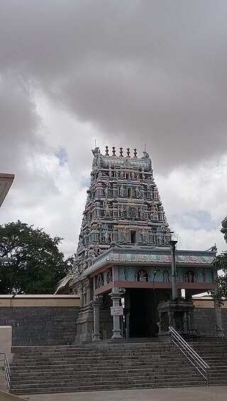
Dharapuram is a town situated along the banks of Amaravati River in Tiruppur district in the Indian state of Tamil Nadu. Dharapuram is one of the oldest towns in South India and was the capital of Kongu Nadu under the Cheras, Western Ganga Dynasty and later Kongu Cholas, at which time it was known as Viradapuram. Amaravathi River flows through the town. As of 2011, the town had a population of 67,007. The city houses famous temples including Agatheeswarar Temple, Kaadu Hanumanthasamy temple and many other old temples.
Kangeyam is a historical town and municipality in Kangeyam Taluk of Tiruppur district in the Indian state of Tamil Nadu. It is situated on National Highway 81. Kangeyam is an economic center in Tamil Nadu. The main commercial interests of the municipality are rice hulling, coconut oil extraction, ghee production, and groundnut cultivation. The town is located 28 km from the district headquarters at Tiruppur, 45 km from the city of Erode, 70 km from the industrial town of Coimbatore,30 km from the town of Dharapuram, 55 km from the city of Karur, 140 km from the Ancient city of Trichy and 441 km from the state capital Chennai.
Kannivadi is a panchayat town in Tiruppur district in the Indian state of Tamil Nadu. It was a part of the Erode District in the past. It is bordered between Karur district and Dharapuram town.
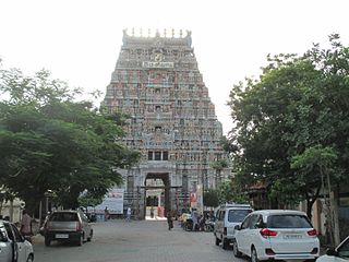
Kodumudi is a panchayat town and taluk headquarters of Kodumudi taluk in Erode district at state of Tamil Nadu, India. Kodumudi has an average elevation of 144 metres (472 feet). Also Kodumudi is an tourism spot. The holy Kaveri river and Magudeswarar temple in Kodumudi attracts thousands of pilgrims daily across South India.
Kolathupalayam is a panchayat town in Dharapuram taluk of Tirupur District in the Indian state of Tamil Nadu. Kolathupalayam Located 5km From Dharapuram.
Kunnathur is a panchayat town in Tirupur district in the Indian state of Tamil Nadu. It was previously under the jurisdiction of the Erode district. However kunnathur is in tiruppur district, legislative assembly consistency for kunnathur is Perundurai which is in Erode district.

Muthur is a panchayat town in Vellakovil block which comes under Kangeyam taluk in Tirupur district, Tamil Nadu, India.

Palladam is a town and First Grade Municipality in Tirupur district in the state of Tamil Nadu, India. It is the headquarters of Palladam Taluk of Tirupur district. Palladam is located on National Highway NH 81. Palladam is a major town with large source of income collected from the business community, which includes Textile industries, Poultry farms, and Agriculture. Palladam High-tech weaving park is a milestone of the town. It is a part of the Coimbatore MP Constituency. Palladam is well known for production of Broiler chicken production and head office of Broiler coordination committee (BCC) situated here.
Vedasanthoor is a panchayat town in Dindigul district Located at Indian state of Tamil Nadu. Vedasanthoor town is 21 km (13 mi) from Dindigul city, 25 km (16 mi) from Oddanchatram town, and 82 km (51 mi) from Madurai.
Vellakovil is a municipal town in Kangeyam taluk of Tirupur District, in the Indian state of Tamil Nadu. It is located on National Highway 81 between Trichy and Coimbatore. The town is spread in an area of 64.75 km2. As of 2011, the town had a population of 40,359. Kannapuram village located near to this town is famous for Kangeyam breed cattle market that happens on every year during Mariyamman temple festival in the month of April. It is an industrialized town with traditional agriculture being the occupation for most of the people. It holds lot of Power looms weaving bedsheets, floor mats and cotton materials being exported to foreign countries via exporters present in Karur.
Sivagiri is a panchayat town in Erode district in the Indian state of Tamil Nadu.
Tiruppur District is one of the 38 districts of the Indian state of Tamil Nadu, formed in 22 February 2009. Dharapuram was the largest taluk by area in the district. The district is well-developed and industrialized. The Tiruppur banian industry, the cotton market, Kangeyam bull and Uthukkuli butter, among other things, provide for a vibrant economy. The city of Tiruppur is the administrative headquarters for the district. As of 2011, the district had a population of 2,479,052 with a sex-ratio of 989 females for every 1,000 males.
Dharapuram taluk is a taluk in Tirupur district of the Indian state of Tamil Nadu. The headquarters is the town of Dharapuram. Dharapuram taluk previously included what is now Kangeyam taluk.
Thirumalaigoundenvalasu is a village and a panchayat in the oddanchatram Taluk of Dindigul district in the South Indian state of Tamil Nadu.
Peramium or Peramiyam is a village and a panchayat near Dharapuram and Mulanur in Tirupur district in the state of Tamil Nadu, India.

Uthiyur is a small town in Kangeyam taluk of Tiruppur district in south Indian state of Tamil Nadu.
