
The Amaravati River is the longest tributary of the Kaveri River in the fertile districts of Udumalpet, Dharapuram and Karur Tamil Nadu state, South India.

The Noyyal River is a small river in Western Tamil Nadu, and a tributary of Kaveri River. It rises from the Vellingiri hills in the Western Ghats in Tamil Nadu, very closer in proximity to Kerala border, and flows through many villages and the cities of Coimbatore, and Tirupur. Then finally, the river drains into the Kaveri River at Noyyal, a village in Karur district named after the river itself. The river's basin is 180 km (110 mi) long and 25 km (16 mi) wide and covers a total area of 3,500 km2 (1,400 sq mi). Cultivated land in the basin amounts to 1,800 km2 (690 sq mi) while the population density is 120 people per km² (311/mi²) in the countryside, and 1000 people per km² (2590/mi²) in the cities. The area is known for its scanty rainfall and the development of the Noyyal River Tanks System to hold any overflow from the rains plus the water of the Northeast and Southwest monsoon season was ecologically important. Kausika river, which originates along the northern side of Coimbatore district in the Western Ghats along with its consequent streams, lake and pond systems is an important tributary of the river. The 173 km (107 mi) long tributary of the Kaveri River filled 32 tanks. These interconnecting tanks held the water flowing from the Noyyal.

Erode is a city in the Indian state of Tamil Nadu. Erode is the seventh largest urban agglomeration in the state, after Chennai, Coimbatore, Madurai, Tiruchirapalli, Tiruppur and Salem. It is also the administrative headquarters of the Erode district. Administered by a city municipal corporation since 2008, Erode is a part of Erode Lok Sabha constituency that elects its member of parliament. Located on the banks of River Kaveri, it is situated centrally on South Indian Peninsula, about 400 kilometres (249 mi) southwest of its state capital Chennai, 250 kilometres (155 mi) south of Bengaluru, 100 kilometres (62 mi) east of Coimbatore and 275 kilometres (171 mi) east of Kochi. Erode is an agricultural, textile and a BPO hub and among the largest producers of turmeric, hand-loom and knitwear, and food products.

Bhavani is an interstate Indian river which flows through Indian states of Kerala and Tamil Nadu, India. It originates from the Western Ghats and is one among the three rivers of Kerala which flows in eastward direction.

The Mettur Dam is one of the largest dams in India and also the largest in Tamil Nadu, located across the river Kaveri where it enters the plains. Built in 1934, it took 9 years to complete. Maximum height and width of the dam are 214 and 171 feet, respectively. The dam receives inflows from its own catchment area, Kabini Dam and Krishna Raja Sagara Dams located in Karnataka. There is a park at the base of the dam called Ellis Park maintained by the Tamil Nadu Public Works Department. It provides irrigation and drinking water facilities for more than 12 districts of Tamil Nadu and hence is revered as the life and livelihood-giving asset of Tamil Nadu.
Chennimalai is a town in Erode district, Tamil Nadu, India. It is popularly known as the 'Handloom Town'.

Dharapuram is a town situated along the banks of Amaravati River in Tiruppur district in the Indian state of Tamil Nadu. Dharapuram is one of the oldest towns in South India and was the capital of Kongu Nadu under the Cheras, Western Ganga Dynasty and later Kongu Cholas, at which time it was known as Viradapuram. Amaravathi River flows through the town. As of 2011, the town had a population of 67,007. The city houses famous temples including Agatheeswarar Temple, Kaadu Hanumanthasamy temple and many others.
Kangeyam is a historical town and municipality in Kangeyam Taluk of Tiruppur district in the Indian state of Tamil Nadu. It is situated on National Highway 81. Kangeyam is an economic center in Tamil Nadu. The main commercial interests of the municipality are rice hulling, coconut oil extraction, ghee production, and groundnut cultivation. The town is located 28 km from the district headquarters at Tiruppur, 45 km from the city of Erode, 70 km from the industrial town of Coimbatore,30 km from the town of Dharapuram, 55 km from the city of Karur, 140 km from the Ancient city of Trichy and 441 km from the state capital Chennai.

Muthur is a panchayat town in Kangeyam taluk in Tirupur district, Tamil Nadu, India.

Udumalai, also known as Udumalaipettai and Udumalpet, is a town in Tiruppur district in the Indian state of Tamil Nadu. Udumalaipettai is located 535 km south west from the state capital, Chennai and 72 km away from Coimbatore, the second largest city in the state.
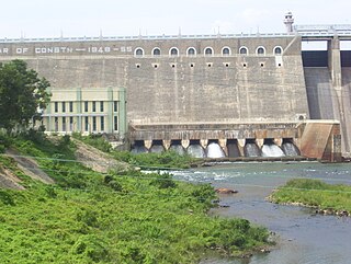
Bhavanisagar Dam or Lower Bhavani Dam, is located in Erode district, Tamil Nadu, India. The dam is constructed on the Bhavani river. It is one of the world's largest earthen dams. The dam is situated some 16 km (9.9 mi) west of Sathyamangalam, is 17 km North of Punjai Puliampatti, is 35 km (22 mi) from Gobichettipalayam and is 36 km (22 mi) north-east to Mettupalayam.
Tiruppur District is one of the 38 districts of the Indian state of Tamil Nadu, formed in 22 February 2009. Dharapuram was the largest taluk by area in the district. The district is well-developed and industrialized. The Tiruppur banian industry, the cotton market, Kangeyam bull and Uthukkuli butter, among other things, provide for a vibrant economy. The city of Tiruppur is the administrative headquarters for the district. As of 2011, the district had a population of 2,479,052 with a sex-ratio of 989 females for every 1,000 males.
Kundadam block is a revenue block in Dharapuram taluk of the Tiruppur district of Tamil Nadu, India. It has a total of 24 panchayat villages.
Dharapuram block is a revenue block in the Tiruppur district of Tamil Nadu, India. It is one among 16 revenue blocks in Tiruppur district. It has a total of 16 panchayat villages. The block had population of 70,372 as of 2011 Census of India.
Tiruppur or Tirupur ( ) is a city in the Indian state of Tamil Nadu. Tiruppur is the administrative headquarters of Tiruppur district and the fifth largest city as well as an urban agglomeration in Tamil Nadu. Located on the banks of Noyyal River, it has been ruled at different times, by the Early Pandyas, Medieval Cholas, Later Cholas, Mysore Kingdom and also British. It is about 450 kilometres (280 mi) southwest of the state capital Chennai, about 50 kilometres (31 mi) east of Coimbatore, 50 kilometres (31 mi) south of Erode, and 50 kilometres (31 mi) north of Dharapuram.
Pongalur is a small town located in Palladam Taluk of Tiruppur district in Tamil Nadu, India. It is located along the Coimbatore - Trichy National highway and headquarters the Pongalur block. It is located 10 km from Palladam, 22 km from Kangeyam, 35 km from Dharapuram and 20 km from district headquarter Tiruppur and 50 km from Coimbatore. It is known for its famous Varadharaja perumal Temple.

Uthiyur is a small town in Kangeyam taluk of Tiruppur district in south Indian state of Tamil Nadu.

Kundadam is a small town located in Dharapuram taluk of Tiruppur district in Indian state of Tamil Nadu. It is the headquarters of the Kundadam Panchayat Union in Tiruppur district. It is located 16Km away from Dharapuram in Coimbatore-Dharapuram highway. In the classical Tamil texts, this town is named as Kundrai, Kundrapuram, Kundrai Managar and Kundridam. The town houses famous temples including Varatharājaperumāl Temple, Kala Bairavar Temple, Kongu Vatuganādha Swāmy Temple, Koṅgar Chinnamman Temple and Vadivudaimangai Udanurai Konguvidangkisuvarar Temple.

Koduvai(Koduvāi) is a small town in Tiruppur District in Tamil Nadu, India. It comes under Pongalur block and Tiruppur South taluk. It is located 26 km away from Dharapuram and 25 km from Tiruppur in Tiruppur-Dharapuram highway. The town houses famous temples including NageswaraSami Temple and PeriyaPerumal Temple.
Lakkamanaickenpatti (Lakkamanāyakkaṉpaṭṭi) is a village located near Vellakoil of Tiruppur district in Tamil Nadu, India.

