
Erode District is one of the 38 districts in the state of Tamil Nadu in India. It was the largest district by area in the state before the formation of Tirupur District in 2009. The headquarters of the district is Erode. It is divided into two revenue divisions, Erode and Gobichettipalayam, and is further subdivided into 10 taluks. Erode District was a part of Coimbatore District before its division into two on 17 September 1979. It covers an area of 5,722 square kilometres (2,209 sq mi), and as of 2011, had a population of 2,251,744.

Erode is a city in the Indian state of Tamil Nadu. The seventh largest urban agglomeration in the state, after Chennai, Coimbatore, Madurai, Tiruchirapalli, Salem and Tiruppur. It is also the administrative headquarters of the Erode district. Administered by a city municipal corporation since 2008, Erode is a part of the Erode Lok Sabha constituency that elects its member of parliament. Located on the banks of River Kaveri, it is situated centrally on South Indian Peninsula, about 400 kilometres (249 mi) southwest of its state capital Chennai and about 80 kilometres (50 mi) east of Coimbatore, about 50 kilometres (31 mi) east of Tiruppur and about 60 kilometres (37 mi) west of Salem. Erode is an agricultural, textile and a BPO hub and among the largest producers of turmeric, hand-loom and knitwear, and food products.
Bhavani is a Municipality in Erode District, Tamil Nadu, India. It is located at the northern periphery of Erode City Municipal Corporation and is around 105 km (65 mi) from Coimbatore and 60 km (37 mi) from Tiruppur and Salem. Bhavani is also known as "Carpet City" as it is known for its carpet industry; blankets and carpets manufactured in the town are known as Bhavani Jamakkalam. As of 2011, the town covers an area of 2.17 square kilometres (0.84 sq mi) and has a population of 39,225. It is a grade II municipality.

Thindal is a neighborhood of Erode city in Tamil Nadu. It is located 8 km from Erode Junction and 7 km from Central Bus Terminus, Erode. It is now officially a part of Erode Municipal Corporation. The locality is well known for the Thindal Murugan Temple.
Perundurai is a Special Grade Town Panchayat in Erode district in the Indian state of Tamil Nadu. At present, Perundurai is the only special grade town panchayat among the 42 town panchayats in the district, sources said. It is located on National Highway 544 connecting Salem with Cochin. It is located 18 kilometres road distance from Erode Central Bus Terminus via Perundurai Road, and 36 kilometres from Tiruppur and 80 kilometres from Coimbatore and Salem and 32 kilometres from Kangayam respectively. Perundurai has developed as the industrial center with SIPCOT Industrial Estate and SEZ Complex. It is the Asia's Second largest SIPCOT.
Thiruvanmiyur is a largely residential neighborhood in the south of Chennai, Tamil Nadu, India. Thiruvanmiyur witnessed a spike in its economy with the construction of Chennai's first dedicated technology office space, the Tidel Information Technology Park in neighboring Taramani. The subsequent rise of several information technology businesses, research centres and offices around Tidel park proved fortuitous for Thiruvanmiyur, as many of the workers at these offices often made Thiruvanmiyur their home. The Marundeeswarar Temple, dedicated to Shiva previously defined the area, leading it to be mentioned in Sangam Tamil epics. It is also commonly referred to as the MICO layout of Chennai city. Other Famous Temples are Ashtalakshmi Temple and Aarupadai Murugan Temple.

Palani (Tamil: [paɻani], is a town and a taluk headquarters in Dindigul district of the western part of Tamil Nadu state in India. It is located about 106 kilometres south-east of Coimbatore and 122 kilometres north-west of Madurai, 67 kilometres from Kodaikanal. The Palani Murugan Temple or Arulmigu Dhandayuthapani Swamy Temple, dedicated to Lord Murugan is situated on a hill overlooking the town. The temple is visited by more than 7 million pilgrims each year. As of 2011, the town had a population of 70,467 which makes it the second largest town in the district after Dindigul.
Thuckalay or Thakkalai (தக்கலை) is a town in Kanyakumari district of Tamil Nadu, India. Thuckalay comes under the Padmanabhapuram Municipality, and is the administrative headquarters of Kalkulam Taluk. The Revenue Divisional Office is located in Mettukadai.
Tiruchengode is a city and selection grade municipality located in southern Indian state of Tamil Nadu.

Chennimalai is a town in Erode district, Tamil Nadu, India. It is popularly known as the 'Handloom Town'.

Dharapuram officially Tharaapuram is a town in Tirupur district in the Indian state of Tamil Nadu. Dharapuram is one of the oldest towns in Tamil Nadu and was the capital of Kongu Nadu under the Cheras, Western Ganga Dynasty and later Kongu Cholas, at which time it was known as Vanchipuri. Amaravathi River flows through the town. As of 2011, the town had a population of 67,007. Dharapuram Municipality is promoted 1st grade municipality on 6 May 1983 Dharapuram was Part of Coimbatore district in the beginning and later it moves to Erode district up to 2009. Dharapuram Town is situated along the banks of River Amaravathi, located in between 10 degree 45 minutes northern latitude and 77 degree 31 minutes eastern latitude with an extent of 7.02 km2. It is a small agricultural marketing centre for a large rural hinterland in the Tirupur District. The town is 50 km towards of the District Headquarters Tirupur, 75 km towards the Erode and 72 km towards the industrial town Coimbatore. The nearest airport is Coimbatore International Airport located 70 km from Dharapuram. Dharapuram was the capital of Noyyal South District before the formation of Coimbatore District.

Uthukuli is a taluk in Tirupur district in the Indian state of Tamil Nadu.
Komarapalayam is a textile town situated on the bank of the Cauvery river, Bhavani River of South India, and is a taluk of Namakkal District, Tamil Nadu, India. Komarapalayam is also called as Kumarapalayam. Komarapalayam and Bhavani are twin cities separated by the Cauvery river. However, Bhavani belongs to Erode district. Komarapalayam is famous for its textile industries.also kumarapalam is famous for traditional leather chappals, As of 2011, the town had a population of 71,594.
Velayuthampalayam is a village located in Karur District in the Indian state of Tamil Nadu. It comes under the jurisdiction of Punjai Pugalur Town Panchayat. This town is situated on the footsteps of Pugali Malai Arunattan Malai, which houses Lord Murugan. The river Cauvery is 3 kilometers away from the town.It is very close to TNPL Kagithapuram. The adjacent places are TNPL Kagithapuram, Thottakuritchi and Karappalayam.
Thamaraipalayam is a village located on the west from banks of the Cauvery, in Erode district, Tamil Nadu, India.
Lakkapuram or Punjai Lakkapuram is a Village Panchayat located in Erode district, in the Indian state of Tamil Nadu. Lakkapuram village falls under Modakurichi taluk.
Pariyur is a panchayat village located near Gobichettipalayam in Erode District of Tamil Nadu state, India. It is located about 3 km from Gobichettipalayam on the way to Anthiyur via Savandapur. It is a religious center with many famous temples including the Pariyur Kondathu Kaliamman temple.

Pudukkaraipudur is a panchayat in Gobichettipalayam taluk in Erode District of Tamil Nadu state, India. It is about 5 km from Gobichettipalayam and 35 km from district headquarters Erode.The village is surrounded by beautiful paddy fields and canals. The village is located on the road connecting Gobichettipalayam with Anthiyur. Pudukkaraipudur has a population of about 1,473. The Pariyur Kondathu Kaliamman temple is about 2 km from Pudukkaraipudur. Other temples are Karungaradu Murugan Temple, Arulmigu Suyambu Makaliamman Temple, Shri Sangili Muniappan Temple and Arulmigu Vayal Karuppsamy Temple.The Bhavani River is around 2.5 km from the village. Paddy, turmeric, sugar cane, banana, palm and coconuts are cultivated in this region.
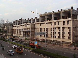
Perundurai Road is one of the major arterial roads in the city of Erode in India. Running from East to West of the city, the road starts from Amma Flyover near Thanthai Periyar Government Hospital and terminates near the western suburb Perundurai. This 17 km stretch of this road further extends to the west connecting SIPCOT Industrial Park and enables further connectivity to Coimbatore and Kochi as NH 544. The commercial and residential establishments along this road make it as the growth identifier of Erode, forecasting the development towards the west. The width of the road is making it four-lane to most of the stretch while few km near the western end is wider to six-lane carriageway.
Uthiyur is a small town in Kangeyam taluk of Tiruppur district in south Indian state of Tamil Nadu.
