
Erode District is one of the 38 districts in the state of Tamil Nadu in India. It was the largest district by area in the state before the formation of Tirupur District in 2009. The headquarters of the district is Erode. It is divided into two revenue divisions, Erode and Gobichettipalayam, and is further subdivided into 10 taluks. Erode District was a part of Coimbatore District before its division into two on 17 September 1979. It covers an area of 5,722 square kilometres (2,209 sq mi), and as of 2011, had a population of 2,251,744.
Sathyamangalam is a town and municipality in Erode district in the Indian state of Tamil Nadu. 8 th century Town. It lies on the banks of the River Bhavani, a tributary of the River Cauvery in the foothills of the Western Ghats. It is about 65 km from Erode, 58 km from Tiruppur and 70 km from Coimbatore. As of 2011, the town had a population of 37,816.

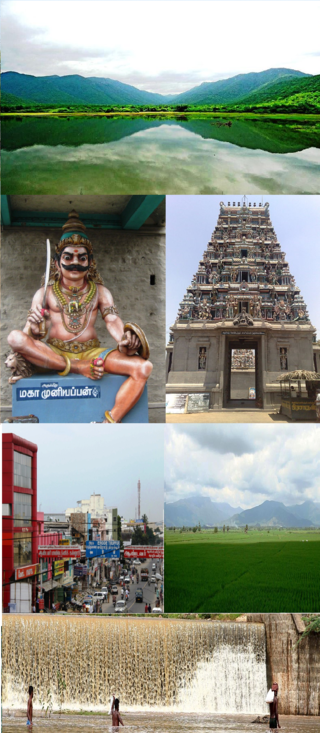
Erode is a city in the Indian state of Tamil Nadu. Erode is the seventh largest urban agglomeration in the state, after Chennai, Coimbatore, Madurai, Tiruchirapalli, Tiruppur and Salem. It is also the administrative headquarters of the Erode district. Administered by a city municipal corporation since 2008, Erode is a part of Erode Lok Sabha constituency that elects its member of parliament. Located on the banks of River Kaveri, it is situated centrally on South Indian Peninsula, about 400 kilometres (249 mi) southwest of its state capital Chennai, 250 kilometres (155 mi) south of Bengaluru, 100 kilometres (62 mi) east of Coimbatore and 275 kilometres (171 mi) east of Kochi. Erode is an agricultural, textile and a BPO hub and among the largest producers of turmeric, hand-loom and knitwear, and food products.
Gobichettipalayam is the Selection grade municipality in the Indian state of Tamil Nadu. It is the administrative headquarters of Gobichettipalayam taluk. It is situated at the center of the South Indian Peninsula, 37 kilometres (23 mi) from the district headquarters Erode ,44 kilometres (27 mi) north of Tiruppur and 80 kilometres (50 mi) east of Coimbatore. Agriculture and textile industries contribute majorly to the economy of the town and is popularly known as the rice bowl of western Tamil Nadu. The town is situated at 213 metres (699 ft) above sea level, surrounded by Western Ghats.

Bhavani is an Indian river which flows through Indian states of Kerala and Tamil Nadu, India. It originates from the Western Ghats of Kerala and is one among the three rivers of Kerala which flows in eastward direction.

Bhavani is a Municipality in Erode District, Tamil Nadu, India. It is located at the northern periphery of Erode City Municipal Corporation and is around 105 km (65 mi) from Coimbatore and 60 km (37 mi) from Tiruppur and Salem. Bhavani is also known as "Carpet City" as it is known for its carpet industry; blankets and carpets manufactured in the town are known as Bhavani Jamakkalam. As of 2011, the town covers an area of 2.17 square kilometres (0.84 sq mi) and has a population of 39,225. It is a grade II municipality.

Dharmapuri is a special grade town in the north western part of Tamil Nadu, India. It serves as the administrative headquarters of Dharmapuri district which is the first district created in Tamil Nadu after the independence of India by splitting it from then Salem district on 2 October 1965. The city is located at 50 km from Krishnagiri, 69 km from Salem, 90 km from Hosur, 117 km from Thiruvannamalai, 126 km from Bangalore and Erode, 181 km from Tiruppur, 200 km from Coimbatore and Tiruchirappalli, 300 km from Madurai and the state capital Chennai. It is located between latitudes N 11 47’ and 12 33’ and longitudes E 77 02’ and 78 40’. It is one of the leading major cultivator and producer of mango in the state along with Krishnagiri often referred as Mango Capital of India.

Dharapuram is a town situated along the banks of Amaravati River in Tiruppur district in the Indian state of Tamil Nadu. Dharapuram is one of the oldest towns in South India and was the capital of Kongu Nadu under the Cheras, Western Ganga Dynasty and later Kongu Cholas, at which time it was known as Viradapuram. Amaravathi River flows through the town. As of 2011, the town had a population of 67,007. The city houses famous temples including Agatheeswarar Temple, Kaadu Hanumanthasamy temple and many others.
Mettupalayam is a municipality town and taluk of the Coimbatore district in the Indian state of Tamil Nadu. It is the third largest town in the Coimbatore District after Coimbatore and Pollachi. It's located to the North of the Coimbatore city on the way to Ooty in the foothills of Nilgiri hills. As of 2011, the town had a population of 66,595. Mettupalayam railway station is the starting point of Nilgiri Mountain Railway and it operates the only rack railway in India connecting Ooty and Mettupalayam.

Vijayamangalam is a census town in Erode district in the Indian state of Tamil Nadu. It is located on National Highway 47 (NH-47) between Perundurai and Perumanallur.
Kavindapadi, also known as Kavundapadi, is located in Erode District of Tamil Nadu, India which is one of the major producers of sugar in India. It is also famous for its agriculture, producing the lump sum amount of sugarcane and bananas to the people of Tamil Nadu. Kavindapadi is located on the way of Erode to Sathyamangalam.
Komarapalayam is a textile town situated on the bank of the Cauvery river, Bhavani River of South India, and is a taluk of Namakkal District, Tamil Nadu, India. Komarapalayam is also called as Kumarapalayam. Komarapalayam and Bhavani are twin cities separated by the Cauvery river. However, Bhavani belongs to Erode district. Komarapalayam is famous for its textile industries; also Kumarapalayam is famous for traditional leather chappals. As of 2011, the town had a population of 71,594. Some of the native people call it as Guberapuri due to high industrial production.
Ayyampalayam village, Kavindapadi post, is a small village of less than 1500 inhabitants, situated in the Bhavani taluk, Erode district in Tamil Nadu.

Bannari is a small village located at a distance of 12 km from Sathyamangalam town and 35 km from Gobichettipalayam town in Erode District and 62 km from Tiruppur city and 82 km from Coimbatore city on Coimbatore-Bangalore NH 209 and it is close to Tamil Nadu and Karnataka border (20 km).

Bannari Amman temple is one of the Amman temples in Tamil Nadu, India. It is located in Bannari on NH 209, near Sathyamangalam, Erode district. The main deity at the temple is goddess Mariamman, an avatar of goddess Parvathi. The goddess is considered powerful in the Tamil and Kannada folklore, and roughly every village in the Kongu region of Tamil Nadu has a Mariamman temple.
Chittar சித்தார்is a village in Bhavani taluk of Erode district, Tamil Nadu.
Erode city being the headquarters of Erode district, in Tamil Nadu, India, has an extensive road and rail transport network in all radial directions, as it lies landlocked.

Coimbatore District was one of the districts of the erstwhile Madras Presidency of British India. It covered the areas of the present-day districts of Coimbatore, Erode and Tirupur and the Kollegal taluk of present-day Karnataka. It covered a total area of 20,400 square kilometres (7,860 sq mi) and was sub-divided into 10 taluks. The administrative headquarters was Coimbatore city. Most of Coimbatore's inhabitants were Tamil-speaking but there were also large numbers of Malayalam, Telugu and Kannada speaking people.

Sathyamangalam Tiger Reserve is a protected area and tiger reserve in the Eastern Ghats in the Erode District of the Indian state of Tamil Nadu. It has a tiger population of 83 individuals and a leopard population of 111 individuals according to the 2019 census.
Gobichettipalayam division is one of the two revenue divisions in Erode district of Tamil Nadu State, India. This Division comprises six Taluks divided into nine CD blocks.


