The Kaveri is one of the major Indian rivers flowing through the states of Karnataka and Tamil Nadu. The Kaveri River rises at Talakaveri in the Brahmagiri range in the Western Ghats, Kodagu district of the state of Karnataka, at an elevation of 1,341 m above mean sea level and flows for about 800 km before its outfall into the Bay of Bengal. It reaches the sea in Poompuhar, in Mayiladuthurai district. It is the third largest river – after Godavari and Krishna – in southern India, and the largest in the state of Tamil Nadu, which, on its course, bisects the state into north and south. In ancient Tamil literature, the river was also called Ponni.

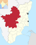
Erode District is one of the 38 districts in the south Indian state of Tamil Nadu. It was the largest district by area in the state before the formation of Tirupur district in 2009 and is the third largest by area, as of 2024. The headquarters of the district is Erode. The district is divided into two revenue divisions, Erode and Gobichettipalayam, and is further subdivided into 10 taluks.

The Noyyal River is a small river in Western Tamil Nadu, and a tributary of Kaveri River. It rises from the Vellingiri hills in the Western Ghats in Tamil Nadu, very closer in proximity to Kerala border, and flows through many villages and the cities of Coimbatore, and Tirupur. Then finally, the river drains into the Kaveri River at Noyyal, a village in Karur district named after the river itself. The river's basin is 180 km (110 mi) long and 25 km (16 mi) wide and covers a total area of 3,500 km2 (1,400 sq mi). Cultivated land in the basin amounts to 1,800 km2 (690 sq mi) while the population density is 120 people per km2 (311/mi2) in the countryside, and 1000 people per km2 (2590/mi2) in the cities. The area is known for its scanty rainfall and the development of the Noyyal River Tanks System to hold any overflow from the rains plus the water of the Northeast and Southwest monsoon season was ecologically important. Kausika river, which originates along the northern side of Coimbatore district in the Western Ghats along with its consequent streams, lake and pond systems is an important tributary of the river. The 173 km (107 mi) long tributary of the Kaveri River filled 32 tanks. These interconnecting tanks held the water flowing from the Noyyal.

Sathyamangalam is a town and municipality in Erode district in the Indian state of Tamil Nadu. It lies on the banks of the Bhavani river, a tributary of the Cauvery in the foothills of the Western Ghats and is the headquarters of Sathyamangalam taluk. It is about 65 km from Erode, 58 km from Tiruppur and 65 km from Coimbatore. As of 2011, the town had a population of 37,816.

Gobichettipalayam is a town and municipality in Erode district of the Indian state of Tamil Nadu. It is the administrative headquarters of Gobichettipalayam taluk. It is situated at the center of the South Indian Peninsula at 213 metres (699 ft) above sea level, surrounded by Western Ghats. It is located 35 kilometres (22 mi) from the district headquarters Erode, 44 kilometres (27 mi) from Tiruppur and 80 kilometres (50 mi) from Coimbatore. Agriculture and textile industries contribute majorly to the economy of the town.

Bhavani is a Municipality in Erode District, Tamil Nadu, India. It is located at the northern periphery of Erode City Municipal Corporation and is around 105 km (65 mi) from Coimbatore and 60 km (37 mi) from Tiruppur and Salem. Bhavani is also known as "Carpet City" as it is known for its carpet industry; blankets and carpets manufactured in the town are known as Bhavani Jamakkalam. As of 2011, the town covers an area of 2.17 square kilometres (0.84 sq mi) and has a population of 39,225. It is a grade II municipality.

Anthiyur is a taluk and panchayat town in the Erode district in the state of Tamil Nadu, India.
Ariyappampalayam is a town panchayat in the Sathyamangalam block of Erode district, Tamil Nadu, India. Upgraded to a town panchayat in 1960, it encompasses Old Kaliyanur, New Kaliyanur, and Ariyappampalayam. Notable features include its proximity to the Bhavani River and the Periyur Maakaaliyamman Temple. It's evolving as a significant town adjacent to Sathyamangalam city and ranks as the 12th largest in Erode district.
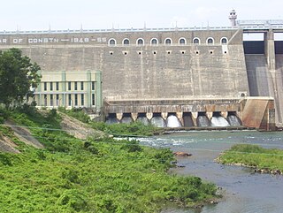
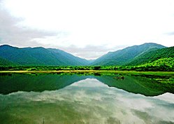
Bhavanisagar Dam or Lower Bhavani Dam, is located in Erode district, Tamil Nadu, India. The dam is constructed on the Bhavani river. It is one of the world's largest earthen dams. The dam is situated some 16 km (9.9 mi) west of Sathyamangalam, is 17 km North of Punjai Puliampatti, is 35 km (22 mi) from Gobichettipalayam and is 36 km (22 mi) north-east to Mettupalayam.

Many Ghat Roads can be found in the Nilgiris District of Tamil Nadu, Southern India. Nearly all of the district is located in the Nilgiri Hills, part of the Western Ghats mountains. This area borders the states of Karnataka and Kerala. The hills consequently can be reached by road from three states. Most of these Ghat Roads go through heavily forested mountains and contain a number of sharp hair-pin bends.
Kalingarayan Canal is a 56.2-mile (90.5 km) long irrigation canal in the Erode district, Tamil Nadu, India. It was constructed by Kongu chieftain Kalingarayan. The canal's source is the Kalingarayan Anicut near Bhavani. The canal irrigates approximately 15,743 acres (6,371 ha) of agricultural land. The project including construction of the dam and canal started in 1271 and was completed in 1283.
Sathanur Dam which forms the Sathanur reservoir, is one of the major dams in Tamil Nadu. It is constructed across the Thenpennai River also called as Pennaiyar River in Thandarampet taluk among Chennakesava Hills. The dam can be reached by road 30 km (19 mi) from Tiruvannamalai City. It was constructed in 1958. There is also a large crocodile farm and a fish grotto. Parks are maintained inside the dam for tourists to visit and the gardens have been used by the film industry. Sathanur dam and reservoir is the third largest in Tamil Nadu after Mettur and Bhavanisagar.

Sathyamangalam Tiger Reserve is a protected area and tiger reserve located along the area straddling both the Western Ghats and Eastern Ghats in the Erode district of the Indian state of Tamil Nadu. The Sathyamangalam Forest Division is part of the Bramhagiri-Nilgiris-Eastern Ghats Elephant Reserve notified in 2003. In 2008, part of the Sathyamangalam Forest Division was declared a wildlife sanctuary, which was further enlarged in 2011 to cover a forest area of 1,411.6 km2 (545.0 sq mi). It is the largest wildlife sanctuary in Tamil Nadu. In 2013, an area of 1,408.6 km2 (543.9 sq mi) of the erstwhile sanctuary was notified as a tiger reserve and it was the fourth tiger reserve established in the state as a part of Project Tiger.

Sigur Plateau is a plateau in the north and east of Nilgiri District in the Nilgiri Hills of Tamil Nadu, South India. It covers the 778.8 square kilometres (300.7 sq mi) portion of the Moyar River drainage basin on the northern slopes of the Nilgiri Hills, south of the Moyar River.

The Siruvani River is a river near Coimbatore, India. It is a tributary of Bhavani river, which in turn is a tributary of Kaveri. Part of the Siruvani River is near Mannarkkad in the Indian District of Palakkad, Kerala. The river leads into two big tourist attractions in Southern India, namely, the Siruvani Dam and the Siruvani Waterfalls. The dam is also near The Banan Fort. Banan Fort and the Siruvani Dam, are 15 to 25 kilometres west of Coimbatore city. The river has a village named after it, or possibly vice versa.
Bhavanisagar block is a revenue block in the Erode district of Tamil Nadu, India. It has a total of 15 panchayat villages; the main town is Bhavanisagar.

Coimbatore is the second largest city in the Indian state of Tamil Nadu. It is situated in the western corner of Tamil Nadu, a short distance from the border with the neighbouring state of Kerala, and is surrounded by the Western Ghats on all sides.

Kodiveri Dam is a masonry dam located on the Bhavani river in Gobichettipalayam taluk, Erode district in the Indian state of Tamil Nadu. The dam is situated along the State Highway 15 about 15 km (9.3 mi) from Gobichettipalayam towards Sathyamangalam in the western region of the state.
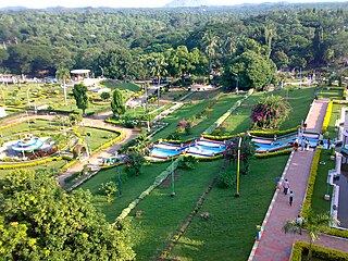
Periya Kodiveri is a panchayat town in Gobichettipalayam taluk in Erode District of Tamil Nadu state, India. It is about 16 km from Gobichettipalayam and 54 km from district headquarters Erode. The panchayat town is located State Highway 15 connecting Gobichettipalayam and Sathyamangalam. Periyakodiveri has population of 12,330 of which 6,181 are males while 6,149 are females as per 2011 census. Kodiveri Dam, a major tourist attraction is located on the outskirts of the town.
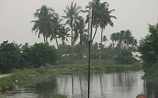
Kalingarayan Anicut is a barrage on the Bhavani river in Erode district, Tamil Nadu. It is located before Kooduthurai where Bhavani meets with Kaveri in Bhavani, Erode.