
The Kaveri is one of the major Indian rivers flowing through the states of Karnataka and Tamil Nadu. The Kaveri river rises at Talakaveri in the Brahmagiri range in the Western Ghats, Kodagu district of the state of Karnataka, at an elevation of 1,341 m above mean sea level and flows for about 800 km before its outfall into the Bay of Bengal. It reaches the sea in Poompuhar in Mayiladuthurai district. It is the third largest river – after Godavari and Krishna – in southern India, and the largest in the State of Tamil Nadu, which, on its course, bisects the state into north and south. In ancient Tamil literature, the river was also called Ponni.
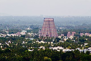
Srirangam, is a neighbourhood in the city of Tiruchirappalli in the Indian state of Tamil Nadu. A river island, Srirangam is bounded by the Kaveri River on one side and its distributary Kollidam on the other side. Considered as the first among the 108 Divya Desams, it is famous for Sri Ranganathaswamy Temple, the largest temple complex in India and the biggest functioning Hindu temple in the world. Srirangam is also home to a significant population of Sri Vaishnavites.

The Kollidam is a river in southeastern India. The Kollidam is the northern distributary of the Kaveri River as it flows through the delta of Thanjavur. It splits from the main branch of the Kaveri River at the island of Srirangam and flows eastward into the Bay of Bengal. The distribution system in Kollidam lies at Lower Anaicut which is an island of river Kollidam.

General Sir Arthur Thomas Cotton was a British general and irrigation engineer.

Kallanai is an ancient dam built by Karikala of Chola dynasty in 150 CE. It is built across the Kaveri river flowing from Tiruchirapalli District to Thanjavur district, Tamil Nadu, India. The dam located in Thanjavur district. Located at a distance of 15 km from Tiruchirapalli, 45 km from Tanjavur. It is the fourth oldest water diversion or water-regulator structures in the world and the oldest in India that is still in use. Because of its spectacular architecture, it is one of the prime tourist spots in Tamil Nadu.

Tiruchirappalli District is one of the 38 districts, located along the Kaveri River, in Tamil Nadu, India. The headquarters of the district is the city of Tiruchirappalli.
Thirukattupalli is a panchayat town near Thiruvaiyaru in Thanjavur district in the Indian state of Tamil Nadu. The economy of this town is majorly based on the agricultural lands of the surrounding villages. Its nearby major cities include Thanjavur and Trichy. Modes of transportation to these cities include regular daily bus services and Budalur Railway Station. Sir P. S. Sivaswami Iyer Higher Secondary School located at the heart of this town serves as the alma-mater for nearly all locals.

Valadi is a zone in Trichy city located on 5 miles from Chathram Bus Terminus in Trichy, Tamil Nadu along the Trichy-Chennai railway. Its size and importance today is much lesser than its status in the pre-independence era, due to massive emigration over the last few decades in search for better career, and its diaspora numbering a few thousands is spread all across the world.

Ucchi Pillayar Temple is a 7th-century Hindu temple, one dedicated to Lord Ganesha located a top of Rockfort, Trichy, Tamil Nadu, India. According to legend, this rock is the place where Lord Ganesha ran from King Vibishana, after establishing the Ranganathaswamy deity in Srirangam. Tiruchirapalli Rock Fort is also fondly called as Malaikottai in Tamil.

The Vennar River or Vennaaru is a river and distributary of the Kaveri River in the Kaveri delta. It flows through the Thanjavur, Tiruvarur, and Nagapattinam districts of Tamil Nadu, India.
The river Arasalar is a river that flows through Tamil Nadu and Pudducherry, and a tributary of Kaveri river which splits into 5 different rivers when it enters into Thanjavur district from Trichy. It separates from river Kaveri in the place near Pullambadi where the Kaveri is stopped by Lower Anaicut and from Thiruvaiyaru. The river is one of the seven rivers that run in the Karaikal region of Puducherry.

Thanjavur District is one of the 38 districts of the state of Tamil Nadu, in southeastern India. Its headquarters is Thanjavur. The district is located in the delta of the Cauvery River and is mostly agrarian. As of 2011, Thanjavur district had a population of 2,405,890 with a sex-ratio of 1,035 females for every 1,000 males.

The Pancharanga Kshetrams or Pancharangams is a group of five sacred Hindu temples, dedicated to Ranganatha, a form of the deity Vishnu, on the banks of the Kaveri River. The five Pancharanga Kshetrams in the order of their successive locations, on the banks of the Kaveri River are: The Srirangapatna called the Adi Rangam, the first temple on the banks of the Kaveri River from the upstream side; the Srirangam in Tamil Nadu known as Kasthuri Rangam or Anthya Rangam, Appalarangam or Koviladi at Tiruppernagar in Tamil Nadu, Parimala Ranganatha Perumal Temple at Tiruindalur in Mayiladuthurai or Mayuram and Vatarangam near Sirkazhi, also listed as Sri Renganatha Perumal Temple, Vadarengam, Tamil Nadu, 609108.
Anaikarai is a village panchayat under Thiruvidaimarudur Taluk in Tanjavur district, Tamil Nadu, India. Anaikarai connects with two major bridges. Nearly 1 km long on both sides. It is an island in the basin of Cauvery river. It is located at the distance of 260 km from Chennai and 25 km from Kumbakonam.
Srirangam Island is a river island in the city of Tiruchirappalli, in the Indian state of Tamil Nadu. The island is formed by the Kaveri and Kollidam Rivers.
Thiruvanaikaval Paadal Petra Sthalam (திருவனைகோவில்) or Thiruvanaikovil is a neighbourhood in the city of Tiruchirappalli in Tamil Nadu, India. It is situated on the northern banks of the Kaveri river, on the Srirangam Island.

The Lower Anaicut or Anaikkarai is a dam and bridge built on the Kollidam in the Indian state of Tamil Nadu.
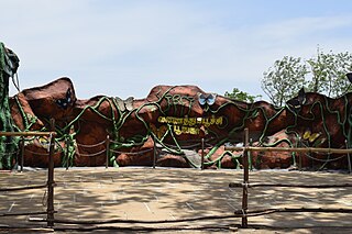
The Tropical Butterfly Conservatory, is located in the Upper Anaicut reserve forest in Srirangam. It covers 25 acres. The conservatory lies in the river Cauvery and Kollidam drainage basin. The Conservatory consists of Butterfly Park and Nakshatravanam. The conservatory falls under Tiruchirappalli Forest Division. This park is the largest butterfly park in Asia

The Ambuliyar or Ambuli River is a non-perennial river in the Pudukkottai and Thanjavur districts of Tamil Nadu, India, that flows southeast into the Palk Strait.


