
The Godavari is India's second longest river after the Ganga river and drains into the third largest basin in India, covering about 10% of India's total geographical area. Its source is in Trimbakeshwar, Nashik, Maharashtra. It flows east for 1,465 kilometres (910 mi), draining the states of Maharashtra (48.6%), Telangana (18.8%), Andhra Pradesh (4.5%), Chhattisgarh (10.9%) and Odisha (5.7%). The river ultimately empties into the Bay of Bengal through an extensive network of tributaries. Measuring up to 312,812 km2 (120,777 sq mi), it forms one of the largest river basins in the Indian subcontinent, with only the Ganga and Indus rivers having a larger drainage basin. In terms of length, catchment area and discharge, the Godavari is the largest in peninsular India, and had been dubbed as the Dakshina Ganga.

The Mahanadi River is a major river in East Central India. It drains an area of around 132,100 square kilometres (51,000 sq mi) and has a total length of 900 kilometres (560 mi). Mahanadi is also known for the Hirakud Dam. The river flows through the states of Chhattisgarh and Odisha and before finally ending in the Bay of Bengal.

The Amaravati River is the longest tributary of Kaveri River in the fertile districts of Udumalpet, Dharapuram and Karur Tamil Nadu state, South India.

The Noyyal River is a small river in Western Tamil Nadu, and a tributary of Kaveri River. It rises from the Vellingiri hills in the Western Ghats in Tamil Nadu, very closer in proximity to Kerala border, and flows through many villages and the cities of Coimbatore, and Tirupur. Then finally, the river drains into the Kaveri River at Noyyal, a village in Karur district named after the river itself. The river's basin is 180 km (110 mi) long and 25 km (16 mi) wide and covers a total area of 3,500 km2 (1,400 sq mi). Cultivated land in the basin amounts to 1,800 km2 (690 sq mi) while the population density is 120 people per km² (311/mi²) in the countryside, and 1000 people per km² (2590/mi²) in the cities. The area is known for its scanty rainfall and the development of the Noyyal River Tanks System to hold any overflow from the rains plus the water of the Northeast and Southwest monsoon season was ecologically important. Kausika river, which originates along the northern side of Coimbatore district in the Western Ghats along with its consequent streams, lake and pond systems is an important tributory of the river. The 173 km (107 mi) long tributary of the Kaveri River filled 32 tanks. These interconnecting tanks held the water flowing from the Noyyal.

The Daman Ganga also called Dawan River is a river in western India. The river's headwaters are on the western slope of the Western Ghats range, and it flows west into the Arabian Sea. The river flows through Maharashtra and Gujarat states, as well as the Union territory of Dadra and Nagar Haveli and Daman and Diu. The industrial towns of Vapi, Dadra and Silvassa lie on the north bank of the river, and the town of Daman occupies both banks of the river's estuary.

Periyar, IPA: [peɾijɐːr], is the longest river and the river with the largest discharge potential in the Indian state of Kerala. It is one of the few perennial rivers in the region and provides drinking water for several major towns. The Periyar is of utmost significance to the economy of Kerala. It generates a significant proportion of Kerala's electrical power via the Idukki Dam and flows along a region of industrial and commercial activity. The river also provides water for irrigation and domestic use throughout its course besides supporting a rich fishery. Due to these reasons, the river has been named the "Lifeline of Kerala". Kochi city, in the vicinity of the river mouth draws its water supply from Aluva, an upstream site sufficiently free of seawater intrusion. Twenty five percent of Kerala's industries are along the banks of river Periyar. These are mostly crowded within a stretch of 5 kilometres (3 mi) in the Eloor-Edayar region (Udhyogamandal), about 10 kilometres (6 mi) north of Kochi harbor.

The Subarnarekha River flows through the Indian states of Jharkhand, West Bengal and Odisha.

Nagarjuna Sagar Dam is a masonry dam across the Krishna River at Nagarjuna Sagar which straddles the border between Nalgonda district in Telangana and Palnadu district in Andhra Pradesh. The dam provides irrigation water to the Nalgonda, Suryapet, Krishna, NTR, Bapatla, Eluru, Palnadu, Khammam, West Godavari, Guntur, and Prakasam districts along with electricity generation.

The Indian Rivers Inter-link is a proposed large-scale civil engineering project that aims to effectively manage water resources in India by linking Indian rivers by a network of reservoirs and canals to enhance irrigation and groundwater recharge, reduce persistent floods in some parts and water shortages in other parts of India. India accounts for 18% of the world population and about 4% of the world’s water resources. One of the solutions to solve the country’s water woes is to link rivers and lakes.
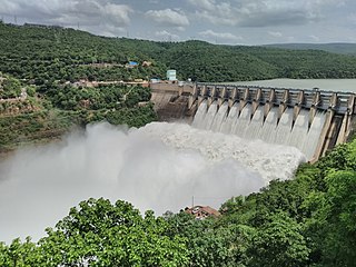
The Srisailam Dam is constructed across the Krishna River in Nagarkurnool district, Telangana and Nandyal district, Andhra Pradesh near Srisailam temple town and is the 2nd largest capacity working hydroelectric station in India.
Bhavanisagar Dam or Lower Bhavani Dam, is located in Erode district, Tamil Nadu, India. The dam is constructed on the Bhavani river. It is one of the world's largest earthen dams. The dam is situated some 16 km (9.9 mi) west of Sathyamangalam, is 35 km (22 mi) from Gobichettipalayam and is 36 km (22 mi) north-east to Mettupalayam.
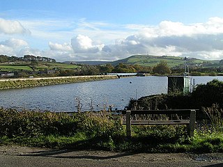
Toddbrook Reservoir, a feeder for the Peak Forest Canal, opened in 1838. It is sited above the town of Whaley Bridge in the Derbyshire High Peak area of England. The reservoir is a Site of Special Scientific Interest (SSSI) providing habitats for herons, ducks and other animals and fish, while rare mosses and liverworts grow on its shores, particularly short-lived species that grow on seasonally exposed mud. The reservoir is used for sailing and angling. The Peak District Boundary Walk runs around the eastern end of the reservoir. The reservoir is owned by the Canal & River Trust and, like the nearby Combs Reservoir, is a feeder reservoir for the Peak Forest Canal. The feeder runs through Whaley Bridge, and with the Combs feed enters the canal system in a pool close to the transhipment shed at the Whaley Bridge canal basin.

Pollution of the Ganges, the largest river in India, poses significant threats to human health and the larger environment. The river, which is severely polluted with human waste and industrial contaminants, provides water to about 40% of India's population across 11 states, serving an estimated population of 500 million people, which is more than any other river in the world.

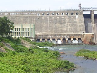
Jayakwadi dam is an earthen dam located on Godavari river at the site of Jayakwadi village in Paithan taluka of Aurangabad district in Maharashtra, India. It is a multipurpose project. The water is mainly used to irrigate agricultural land in the drought-prone Marathwada region of the state. It also provides water for drinking and industrial usage to nearby towns and villages and to the municipalities and industrial areas of Aurangabad and Jalna districts. The surrounding area of the dam has a garden and a bird sanctuary.

Interbasin transfer or transbasin diversion are terms used to describe man-made conveyance schemes which move water from one river basin where it is available, to another basin where water is less available or could be utilized better for human development. The purpose of such water resource engineering schemes can be to alleviate water shortages in the receiving basin, to generate electricity, or both. Rarely, as in the case of the Glory River which diverted water from the Tigris to Euphrates River in modern Iraq, interbasin transfers have been undertaken for political purposes. While ancient water supply examples exist, the first modern developments were undertaken in the 19th century in Australia, India and the United States, feeding large cities such as Denver and Los Angeles. Since the 20th century many more similar projects have followed in other countries, including Israel and China, and contributions to the Green Revolution in India and hydropower development in Canada.
Mamannar Kalingarayan Canal is a 56.2-mile (90.5 km) long irrigation canal in the Erode district, Tamil Nadu, India. It was constructed by Chieftain Mamannar Kalingarayan Gounder and completed in 1283. The canal's source is the Kalingarayan Anicut dam near Bhavani, Erode. The canal irrigates approximately 15,743 acres (6,371 ha) of agricultural land.
Ungampalayam is a village in the South Indian state of Tamil Nadu.
The Noyyal Orathuppalayam Dam and Reservoir, also called Orathuppalayam Dam, is located on the Noyyal River between Chennimalai and Kangayam in Tirupur District, Tamil Nadu, South India. The dam is situated 16 km (9.9 mi) north of Kangayam and 26 km (16 mi) east of Tirupur.

The Sahibi river, also called the Sabi River, is an ephemeral, rain-fed river flowing through Rajasthan, Haryana and Delhi states in India. It drains into Yamuna in Delhi, where its channeled course is also called the Najafgarh drain, which also serves as Najafgarh drain bird sanctuary. Sahibi is a seasonal river which is 300 km long and flows from Aravalli hills in Rajasthan to Haryana, of which 100 km is in Haryana.

The Pazhassi Dam also called Kulur Barrage is a stone masonry diversion structure in Kannur district, Kerala, India. It is named after king Pazhassi Raja, a patriot who died a heroic death in the war. The dam is constructed across the west flowing Bavali river near Veliyambra. It was commissioned by Prime Minister Morarji Desai in 1979. It mainly functions as an irrigation dam, serving a command area of 11,525 hectares in Iritty taluk of the Kannur District. The water from this dam also meets the drinking water requirement of Kannur district. The dam site and the reservoir are famous for their scenic beauty.
