Ungampalayam

Last updated

Ungampalayam
Village
Nickname: 
Noyyal oor
India Tamil Nadu location map.svg
Red pog.svg
Ungampalayam
Location in Tamil Nadu, India
India location map.svg
Red pog.svg
Ungampalayam
Ungampalayam (India)
Coordinates: 11°2′N77°50′E / 11.033°N 77.833°E / 11.033; 77.833 Coordinates: 11°2′N77°50′E / 11.033°N 77.833°E / 11.033; 77.833
CountryFlag of India.svg  India
State Tamil Nadu
Region Kongu Nadu(West Tamil Nadu)
District Karur District
Village Panchayat1700
Talukas K.Paramati
Population
 (2011)
  Total210
Languages
  Official Tamil
Time zone UTC+5:30 (IST)
PIN
638151
Telephone code91 (4204)
Literacy40%
Lok Sabha constituencyKarur
Vidhan Sabha constituencyAravakuruchi
Distance from Chennai 436 kilometres (271 mi) NE (rail)
Distance from Bangalore 366 kilometres (227 mi) N (land)
Climate Tropical climate (Köppen)
Precipitation 1,050 millimetres (41 in)
Avg. annual temperature28 °C (82 °F)
Avg. summer temperature34.3 °C (93.7 °F)
Avg. winter temperature24 °C (75 °F)

Ungampalayam is a village in the South Indian state of Tamil Nadu.

Contents

Location

The village is located in the Tamil Nadu, Karur District, Karur Paramathi Block, Thurkatchi Panchayat. It is located 46 km from Erode, 30 km from Karur, 9 km from Kodumudi and 16 km from Muthur. The village is on the banks of Noyyal River.

Ungampalayam Ungampalayam.jpg
Ungampalayam

The village is named after Ungaan – Stone Carver (Ottan), who had been living there before people move from Varatu Karai near the Village.

History

The Kongu vellalars are very studious people, who migrated from the lush, fertile Cauvery delta in Tanjore and Trichy to the wild forests upriver Cauvery. The Chola kingdom which flourished in the 9th century till 13th century, need to expand its land of cultivation and being wealthy to undertake such endowers.

The delta becomes crowded forcing enterprising people to expand to forest and built villages. They move up river and by their sheer hard work and persistence had survived and created villages in the Kongu region, and they are called Kongu Vellalars ("Farmers of Kongu").

The expansion stated in near 10th century continued as the families and clan expands till 700 years later. In 1700s Maniyan clan people from Mohanur, Namakkal Dist (With deity of Chellandi amman and Navaladi Karuppusamy) in need of resources migrated again from there. They travelled along the River Cauvery and reached River Noyyal, which is Cauvery's tributary.

They got settled near Noyyal River around Thurkatchi – "Reign of Goddess Durga" (Wrongly spelt as Thukkatchi, "Reign of Worry"). They constructed clan deity in Kattampatti for Chellandi amman and Sekkadi Periyasamy. The deity Sekkadi Periyasamy has been installed by a Vaaniyar (Oil miller) sage, so called Sekkadi (Oil pressing place).

These people are called as a new section of Maniyans as Thurkatchi (Thukkatchi) Maniyan Kootam, having clan temple in Kattampatti (2 km). They belong to third section of Maniyan kootam, apart from Mohanur Maniyan and Muthur Maniyan.

The village

The village has deity of Bhagavathi amman and Kuppayi amman for prosperity and protection. The village once spotted with river shore of sand and Neem forest with a fresh fish and clean wonderful river. Now it has become sorrow and dumping ground of Industrial effluent and sewages.

The village now accommodates approximately 50 families. People now started living near the farm, building houses there. East side of the village people of unprivileged live in Ungampalayam Muralai. The village is on the south banks of Noyyal river, thus fall under Karur District (Noyyal river is the border).

The village has close relationship with villages around there like Kattur, Karungalkadu, Thukachi, Kattampatti, NariKattuValasu, Puthupalayam, Pillapalayam, Ramanathapuram, Anjur, Valayapalayam, ChinnaValayaPalayam, NallaSelliPalayam, Murgampalayam to mention a few surrounding villages. Bore well water from Pillapalyam is supplied to Ungampalayam, for folks livelihoods.

Irrigation

The agriculture activities are carried out with water from canal from a small dam on the Noyyal river in Karvazhi Village (5 km) called Aathupalayam Dam, which will supply water for 3–5 months. After that people should depend on the Well for the agriculture. About half the year the water scarcity is there. From 2005 to 2008, drought-like conditions existed due to rain scarcity; crop and coconut trees dried away, and most of them died.

Due to the release of stored effluent from the Orathuppalayam Dam, Tirupur District even the small fresh water available from a seasonal river are not stored in the Aathupalayam dam.

Ecological deterioration

The sewages of Coimbatore and Tirupur and industrial effluent from dyeing factories and textile processing plant of Triupur and Coimbatore changed the ecology of the river.
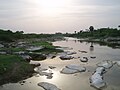
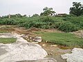
The river water now running mostly as coloured [1] and even cattle are not to be let drink the water, if came to contact with skin it causes inflammation and allergies to humans.

Thorn Infested Noyyal, Ungampalayam4.jpg
Thorn Infested

People have to depend on the Cauvery water line for drinking and utility water. Before the 1990s people used to swim and this used to be fertile and lush area then.

Now the river is a large sewage and banks are full of the Prosopis juliflora (seemai karuvel, vilayati babul), an invasive thorn bush. The village doesn't command a Tar road and transport is headache to the people living there.

Livelihood deterioration

Begin surrounded by districts of Tirupur, Erode where the road and electricity facilities are well developed, this K.Paramathi block of Karur district look as undernourished desert. Even the bridges built on Noyyal in Anjur (5 km) or Kattampatti (2.5 km) or Thukachi (1 km) are done by people of the village, with a minor contribution from the government.

So with no proper livelihood educated people move to towns, farmers shift to nearby villages with better transport. And young people are moving to Finance business in Kerala and Karnataka. As an irony people go to work in Tirupur, which is the source of the deterioration. From land holding Farmers to Wage workers in mills of Tirupur, thus feeding the market of cheap labor.

On the southwest side a new quarry is started in 2007 called SVBM. These people has created some 2–3 km tar road for their use, there by beneficial to people. There are still problem of the dust sweeping through houses and lands of the villagers due to the quarry.

Noyyal tears

According to the state Pollution Control Board the accumulated pollution loads between 1980 and 2000 are as follows: [2]

Total Dissolved Substances (TDS)23.54 lakh tonnes
Chlorides13.11 lakh tones
Sulphates1.25 lakh tones
Total Solid Substances (TSS)0.97 lakh tonnes
Chemical Oxygen Demand (COD)0.90 lakh tones
Biochemical Oxygen Demand (BOD)0.29 lakh tones
Oil & Grease0.01 lakh tonnes

A study, called 'Biological Monitoring of Genotoxic Hazards Related to Textile Dyeing Industries,' by the PSG College of Arts and Science in Coimbatore, showed that tadpoles in Noyyal had significant DNA damage and that fish organs were highly contaminated. Groundwater samples they collected revealed amines, which are capable of inducing DNA strand breaks in humans. Another report from the University of Madras (Chennai) notes that the Noyyal is dead, because of inflow of industrial effluents.

A report by the Linkoping University in Sweden notes that till the mid-90s, "Approximately 90 million litres of water was used and discharged from the dyeing and bleaching industry in Tirupur. Virtually all of this was let out without treatment." While common effluent treatment plants have been set up since – treating only a fraction of the 100,000 million litres daily – the damage has been done.

See also

Related Research Articles

<span class="mw-page-title-main">Noyyal River</span> River in India

The Noyyal River is a small river in Western Tamil Nadu, and a tributary of Kaveri River. It rises from the Vellingiri hills in the Western Ghats in Tamil Nadu, very close to Kerala border, and flows through many villages and the cities of Coimbatore, and Tirupur finally draining into the Kaveri River at Noyyal, a village in Karur district named after the river itself. The river's basin is 180 km (110 mi) long and 25 km (16 mi) wide and covers a total area of 3,500 km2 (1,400 sq mi). Cultivated land in the basin amounts to 1,800 km2 (690 sq mi) while the population density is 120 people per km² (311/mi²) in the countryside, and 1000 people per km² (2590/mi²) in the cities. The area is known for its scanty rainfall and the development of the Noyyal River Tanks System to hold any overflow from the rains plus the water of the Northeast and Southwest monsoon season was ecologically important. Kausika river in the northern side of Coimbatore district along with its lake and pond systems is an important tributory. The 173 km (107 mi) long tributary of the Kaveri River filled 32 tanks. These interconnecting tanks held the water flowing from the Noyyal.

<span class="mw-page-title-main">Namakkal district</span> District of Tamil Nadu in India

Namakkal District is one of the 38 districts in the state of Tamil Nadu, India. The district was bifurcated from Salem District with Namakkal town as headquarters on 25 July 1996 and started to function independently from 1 January 1997. The district has seven taluks (subdivisions): Tiruchengode, Namakkal, Rasipuram, Paramathi Velur, Sendamangalam, Kumarapalayam, Kolli Hills and Mohanur. It has two revenue divisions: Tiruchengode and Namakkal. As of 2011 census, Namakkal district had a population of 1,726,601 with a sex-ratio of 986 females for every 1,000 males and Tiruchengode is the largest city in terms of population. Namakkal district is geographically affiliated to Kongu Nadu region. The district is famous for its large poultry industry, egg production and lorry bodybuilding industry, for which it is often referred to as "Egg City" and "Transport Hub of South India".

<span class="mw-page-title-main">Aravakurichi</span> Town in Tamil Nadu, India

Aravakurichi is a panchayat town and a Taluk headquarters in Karur district in the state of Tamil Nadu, India. Aravakurichi is well known in Tamil Nadu as a major market for Moringa oleifera vegetable. Aravakurichi is the headquarters of Aravakurichi taluk which consists of 40 revenue Villages.

Chennimalai is a town in Erode district, Tamil Nadu, India. It is popularly known as the 'Handloom Town'.

<span class="mw-page-title-main">Dharapuram</span> Historical town in Tamil Nadu, India

Dharapuram officially Tharaapuram is a town situated along the banks of Amaravati River in Tiruppur district in the Indian state of Tamil Nadu. Dharapuram is one of the oldest towns in Tamil Nadu and was the capital of Kongu Nadu under the Cheras, Western Ganga Dynasty and later Kongu Cholas, at which time it was known as Vanchipuri. Amaravathi River flows through the town. As of 2011, the town had a population of 67,007. Dharapuram Municipality is promoted 1st grade municipality on 6 May 1983. Dharapuram was Part of Coimbatore district in the beginning and later it moves to Erode district up to 2009.

Mohanur is a taluk in the Namakkal district of the Indian state of Tamil Nadu. The Mohanur Panchayat Union includes Mohanur Town, Pettapalayam, Manappalli, Rasipalayam, Kumaripalayam, Sengappalli, Ediyar, Peramandampalayam, Ariyur, Aniyapuram, and Valayapatti. It is linked to Tiruchirappalli, Salem, Erode, and Karur districts by road.

<span class="mw-page-title-main">Muthur</span> Town in Tamil Nadu, India

Muthur is a panchayat town in Kangeyam taluk in Tirupur district, Tamil Nadu, India.

Paramathi Velur, a town in Paramathi-Velur taluk, Namakkal District, Tamil Nadu, India is situated just off the Srinagar - Kanyakumari National Highway 44 (India). This town is also called as Paramathi Velur, with STD Code 04268 & Postal code 638182.

Manapalli is a small village on the northern bank of the Cauvery River in the Namakkal district of Tamil Nadu, India. Over 5000 people live in this village, which includes Manapalli, GanapathiPalayam, Rasagounden Pudur, Ramanaicken Palyam, Ellaikattuputhur, Kunnipalayam, Theerthampalayam, Aruvankattur, Ganeshapuram, Chennakkal Pudur, and Pettapalayam. The village is composed of mostly Hindus.

<span class="mw-page-title-main">Tiruppur district</span> District of Tamil Nadu in India

Tiruppur District is one of the 38 districts of the Indian state of Tamil Nadu, formed in 22 February 2009. Dharapuram was the largest taluk by area in the district. The district is well-developed and industrialized. The Tiruppur banian industry, the cotton market, Kangeyam bull and Uthukkuli butter, among other things, provide for a vibrant economy. The city of Tiruppur is the administrative headquarters for the district. As of 2011, the district had a population of 2,479,052 with a sex-ratio of 989 females for every 1,000 males.

<span class="mw-page-title-main">Bannari Mariamman Temple</span>

Bannari Amman temple is one of the Amman temples in Tamil Nadu, India. It is located in Bannari on NH 209, near Sathyamangalam, Erode district. The main deity at the temple is goddess Mariamman, an avatar of goddess Parvathi. The goddess is considered powerful in the Tamil and Kannada folklore, and roughly every village in the Kongu region of Tamil Nadu has a Mariamman temple.

<span class="mw-page-title-main">Pasupateeswarar temple, Karur</span> Temple in Tamil Nadu, India

Pasupateeswarar temple Karur, is located in Karur and is one of the seven Sivastalams. This city was called karuvoor during the time of Sambandar's visit to this temple. From the inscriptions so far deciphered, it is clear that the temple existed during the reign of the king Rajendra Chola since he gifted away land to this temple. For the Kongu Cholas and Kongu Pandyas, the temple was a favourite and, it the drew undivided attention of the Vijayanagar rulers too.

Thamaraipalayam is a village located on the west from banks of the Cauvery, in Erode district, Tamil Nadu, India.

<span class="mw-page-title-main">Pugalur</span> Municipality in Tamil Nadu, India

Pugalur is a municipality in Karur district in Tamil Nadu, India. It is divided into two parts, Nanjai and Punjai. Nanjai refers to land with plenty of water, and Punjai refers to land with few bodies of water. In the Nanjai area it is known as Nanjai Pugalur and in the Punjai area is known as Punjai Pugalur.

Vangal is a village in the Karur district of the Indian state of Tamil Nadu. It is situated 80 km (50 mi) from Tiruchirappalli and 7 miles from Karur city. Vangal is also known as Vangal-Kuppuchipalayam and Vangal Palayur.

Kalikkavalasu is a village near Chennimalai in Erode district of Tamil Nadu, India. The village is an industrial area with many dyeing units and handlooms. The local temples are Pillayar Kovil, Karuppana Swamy Kovil, and Maduraiveeran temple.

The Noyyal Orathuppalayam Dam and Reservoir, also called Orathuppalayam Dam, is located on the Noyyal River between Chennimalai and Kangayam in Tirupur District, Tamil Nadu, South India. The dam is situated 16 km (9.9 mi) north of Kangayam and 26 km (16 mi) east of Tirupur.

The Aathupalayam Dam is situated in Karvazhi Village near Thennilai of K. Paramathi Taluk in Karur District. The parched aycut area has not been receiving supplies as the Aathupalayam reservoir had become a storage tank for Orathuppalayam polluted water flowing down the River Noyyal over the past few years.

Sottaiyur is a village located in Punjai Pugalur Municipality in Karur District in the Indian state of Tamil Nadu.

<span class="mw-page-title-main">Tiruppur</span> City in Tamil Nadu, India

Tiruppur or Tirupur is a city in the Indian state of Tamil Nadu. Tiruppur is the administrative headquarters of Tiruppur district and the Sixth largest city as well as an urban agglomeration in Tamil Nadu. Located on the banks of Noyyal River, it has been ruled at different times, by the Early Pandyas, Medieval Cholas, Later Cholas, Mysore Kingdom and the British. It is about 450 kilometres (280 mi) southwest of the state capital Chennai about 50 kilometres (31 mi) east of Coimbatore 50 kilometres (31 mi) south of Erode and 50 kilometres (31 mi) north of Dharapuram.

References

  1. "Polluter's Pay".
  2. "The River Noyyal: As dead as they get".