Katary Falls

Last updated

Coordinates: 11°20′17″N76°44′12″E / 11.338032°N 76.736777°E / 11.338032; 76.736777

Geographic coordinate system Coordinate system

A geographic coordinate system is a coordinate system that enables every location on Earth to be specified by a set of numbers, letters or symbols. The coordinates are often chosen such that one of the numbers represents a vertical position and two or three of the numbers represent a horizontal position; alternatively, a geographic position may be expressed in a combined three-dimensional Cartesian vector. A common choice of coordinates is latitude, longitude and elevation. To specify a location on a plane requires a map projection.

Katary Falls Katary Falls (Kattery Falls) from Below.jpg
Katary Falls
Katery Falls in 2010 Kataryfall,selas,coonoor,india.jpg
Katery Falls in 2010
in and around Katery Falls Places,around katery falls,coonoor.jpg
in and around Katery Falls

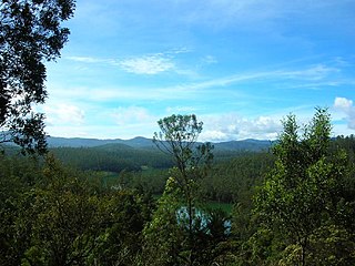
Katary Falls is approximately 10 km from Coonoor in the Nilgiris district in the state of Tamil Nadu, India. At 55 metres (180 ft) in height, Katary Falls is third largest waterfall in the Nilgiris; one can reach it by trecking. [1]

Coonoor Hill station in Tamil Nadu, India

Coonoor is a Taluk and a municipality of the Nilgiris district in the Indian State of Tamil Nadu. As of 2011, the town had a population of 45,494.

Tamil Nadu State in Southern India

Tamil Nadu is one of the 29 states of India. Its capital and largest city is Chennai. Tamil Nadu lies in the southernmost part of the Indian subcontinent and is bordered by the union territory of Puducherry and the South Indian states of Kerala, Karnataka, and Andhra Pradesh. It is bounded by the Eastern Ghats on the north, by the Nilgiri Mountains, the Meghamalai Hills, and Kerala on the west, by the Bay of Bengal in the east, by the Gulf of Mannar and the Palk Strait on the southeast, and by the Indian Ocean on the south. The state shares a maritime border with the nation of Sri Lanka.

India Country in South Asia

India, also known as the Republic of India, is a country in South Asia. It is the seventh largest country by area and with more than 1.3 billion people, it is the second most populous country as well as the most populous democracy in the world. Bounded by the Indian Ocean on the south, the Arabian Sea on the southwest, and the Bay of Bengal on the southeast, it shares land borders with Pakistan to the west; China, Nepal, and Bhutan to the northeast; and Bangladesh and Myanmar to the east. In the Indian Ocean, India is in the vicinity of Sri Lanka and the Maldives, while its Andaman and Nicobar Islands share a maritime border with Thailand and Indonesia.

The falls are the site of India's first hydel power plant, the Kateri hydroelectric system. [1]

Kateri hydroelectric system

The Kateri (Katery) hydro electric power station is located in Nilgiris, Tamil Nadu, India. It is a series of dams and a power house with four 125 KW generators and one 500 KW. The site was the first hydro-electric plant in India, and powers the Cordite Factory at Aruvankadu

See also

Catherine Falls

Catherine Falls is a double-cascaded waterfall located in Kotagiri, The Nilgiris District, Tamil nadu and it is also a major tourist spot in Kotagiri, located on the Mettupalayam road branching off at Aravenu. The upper fall drops to the floor, and is the second highest in the Nilgiri mountains. The waters from the upper stream of the Kallar river are crossed by the invisible Mettupalyam-Ooty road beyond the mountains in the south-west. The height of water falls is about 250 ft.Catherine Falls is named after the wife of M.D. Cockburn, believed to have introduced the coffee plantation to Kotagiri. The native name of the Catherine Falls is Geddhehaada Halla, meaning "Foothills Dale River". It can clearly been seen from the top of Dolphin's Nose if seeing the entire waterfall as one total impression is what you are looking for. It is also possible to take a road to the top of the falls.

Sims Park, Coonoor

Sim's Park is in Coonoor, The Nilgiris, Tamil Nadu. It is an important tourist place to visit in Coonoor, at a height of 1780 meters above mean sea level. Here the maximum temperature goes up to 30 degree Celsius and the minimum falls to 5°C. The average rain fall of this garden is 150 cm. It extends over an area of 12 hectares of undulating land and possesses a number of natural advantages.

Related Research Articles

The Nilgiris District District in Tamil Nadu, India

The Nilgiris District is in the southern Indian state of Tamil Nadu. Nilgiri is the name given to a range of mountains spread across the borders among the states of Tamil Nadu, Karnataka and Kerala. The Nilgiri Hills are part of a larger mountain chain known as the Western Ghats. Their highest point is the mountain of Doddabetta, height 2,637 m. The small district is contained mainly within this mountain range; the administrative headquarters is located at Ooty.

Nilgiri Mountain Railway Heritage rail line in India

The Nilgiri Mountain Railway (NMR) is a 1,000 mmmetre gauge railway in Tamil Nadu, India, built by the British in 1908. The railway is operated by the Southern Railway and is the only rack railway in India.

Wellington, Tamil Nadu Townl in Tamil Nadu, India

Wellington is a town in The Nilgiris District in the Indian state of Tamil Nadu. Wellington is home to The Defence Services Staff College (DSSC), a premier tri-service training establishment that imparts training to middle level officers of the three wings of the Indian Armed Forces, friendly foreign countries and various Indian Civil Service departments. The Nilgiri Passenger train passes through Wellington, which has a railway station. The college has a colourful past and traces its lineage to 1905 when it was set up at Devlali. Sometime after the partition of the Indian Subcontinent, the college shifted to Wellington in The Nilgiri Hills. This town is located near the city of Coonoor.

Wellington is a cantonment town in the Nilgiris District of Tamil Nadu. It is the Regimental Centre for the Madras Regiment of the Indian Army. One of its most famous residents was Field Marshal Sam Manekshaw, who died in the town on June 27, 2008. This town is adjacent to the city of Coonoor. Its Postal Index Number is 643231.

Nilgiri Mountains Range of mountains.

The Nilgiri Mountains form part of the Western Ghats in western Tamil Nadu of Southern India. At least 24 of the Nilgiri Mountains' peaks are above 2,000 metres (6,600 ft), the highest peak being Doddabetta, at 2,637 metres (8,652 ft).

Bandishola is a Panchayat village in Coonoor Taluk of The Nilgiris District, Tamil Nadu, India. The town takes its name from a nearby Shola.

Aravenu village in Tamil Nadu, India

Aravenu is a village in Kotagiri Taluk of The Nilgiris District, Tamil Nadu, India. The population is largely Badaga and it is thought to be an original Badaga Hatti. It is the headquarters of the Jackanarai panchayat.

Coonoor is a state assembly constituency in Nilgiris district in Tamil Nadu. It is a Scheduled Caste reserved constituency.

Coonoor taluk is a taluk of Nilgiris district of the Indian state of Tamil Nadu. The headquarters of the taluk is the town of Coonoor

The Coonoor block is a revenue block in the Nilgiris district of Tamil Nadu, India. It has a total of 6 panchayat villages.

Lamb's Rock is a tourist spot in Coonoor, Tamil Nadu, India, on the slopes of the Nilgiri Hills. It is located at a distance of 8 kilometers from Coonoor. It has a view of the Coimbatore plains, tea estates and coffee estates.

Dolphins Nose, Coonoor

Dolphin's Nose Viewpoint is a tourist spot in Coonoor, The Nilgiris District, Tamil Nadu. Dolphin's Nose is well over 1,550 Meter above sea level, 10 km from Coonoor and is a spectacular spot to visit. The tip of the peak resembles a dolphin's nose, hence the name Dolphin's Nose. It is an enormous rock formation that is entirely unique. There are gigantic ravines found both to the left and right of Dolphin's Nose and there is a view of inspiring Catherine Falls with its continuing stream several thousand metres below which is located a relatively short distance away opposite of the Dolphin's Nose. Best part of spot are the hairpin turns and tea plantations on the way

Law's Falls is a tourist spot in Coonoor, The Nilgiris, Tamil Nadu.

Lady Canning's Seat is major tourist spot in Coonoor, The Nilgiris, Tamil Nadu. It is situated 9 km from the township Coonoor. The site is named after Countess Charlotte Canning.

Droog Fort, Coonoor

Droog Fort is a historic fort located 15 kilometres (9.3 mi) from Coonoor, The Nilgiris, Tamil Nadu. The fort was used as an outpost by Tipu Sultan in the 18th century. Today, the fort is in ruins, with only one wall remaining. The site attracts tourists, who reach the fort by hiking through the Nonsuch Tea Estate.

Rangaswamy Peak and Pillar

Rangaswamy Peak and Pillar is a tourist spot in Kotagiri, The Nilgiris, Tamil Nadu. It is located at a distance of 20 km from Kotagiri. Its a very steep peak and not climbed yet. The hill station of Kotagiri has many tourist attractions spot, which include Kodanad View Point, Catherine Falls, Elk falls, Long wood Shola, Mekanad Falls and Rangaswamy Peak and Pillar. The best season to visit is in summer.

ATC is a locality in the Ooty township of the Nilgiris district in Tamil Nadu, India. It is located by the Ooty - Coonoor road, which is part of the Nilgiri Ghat Roads NH 67. One of the most notable landmarks in the locality is the ATC bus stand, which in turn is about 1 km from the Ooty bus stand.

References

  1. 1 2 "the Coonoor in Tamil Nadu". visitindia.org.in. Retrieved 2011-09-21.