
The Oxley Wild Rivers National Park is a protected national park that is located in the Northern Tablelands region of New South Wales, Australia in the Port Macquarie-Hastings City Council and Walcha Shire councils. The 145,223-hectare (358,850-acre) park is situated 445 kilometres (277 mi) north of Sydney and is named in memory of the Australian explorer John Oxley, who passed through the area in 1818 and is one of the largest national parks in New South Wales.

Pachmarhi is a hill station in Hoshangabad district of Madhya Pradesh state of central India. It has been the location of a cantonment since British Raj. It is widely known as Satpura ki Rani, situated at a height of 1067 m in a valley of the Satpura Range in Hoshangabad district. Dhupgarh, the highest point (1,352 m) in Madhya Pradesh and the Satpura range, is located here. It is a part of Satpura Biosphere Reserve. Pachmarhi is a hill station of central India. It is also famous for Satpura Tiger Reserve, Satpura National Park, Lord Shiva, Pandavas of Mahabharata.

Ponmudi also known as Kashmir of Kerala is a hill station in the Peringamala gramapanchayath of Trivandrum District of Kerala in India. It is located 22km west of vithura town, 53 km north-east of Trivandrum City, 78 km south-east of Varkala town and 69 km north-east of Kovalam Beach at an altitude of 1,100 m (3,600 ft). Ponmudi (Varayadumotta) peak is a part of the Western Ghats mountain range that runs parallel to the Arabian Sea. Ponmudi is also called Kashmir of Kerala and is a popular honeymoon destination in South India. The normal temperature of Ponmudi is between 18 and 25 °C.

Kanyakumari district is one of the 38 districts in Tamil Nadu state and the southernmost district in mainland India. It stands second in terms of population density among the districts of Tamil Nadu and the second most urbanized, next only to Chennai district. It is also the richest district in Tamil Nadu in terms of per capita income, and also tops the state in Human Development Index (HDI), literacy, and education. The district's headquarters is Nagercoil.

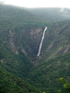
Dudhsagar Falls is a four-tiered waterfall located on the Mandovi River in the Indian state of Goa. It is 60 km from Panaji by road and is located on the Belgaum–Vasco da Gama rail route about 46 km east of Madgaon and 80 km south of Belagavi. Dudhsagar Falls is amongst India's tallest waterfalls with a height of 310 m (1017 feet) and an average width of 30 metres (100 feet).
Kanger Ghati National Park was declared a national park in 1982 by the Government of India. Near Jagdalpur in the Bastar region of Chhattisgarh, it is one of India's densest national parks, and is known for its biodiversity, landscape, waterfalls, and subterranean geomorphologic limestone caves, and as the home of the Bastar hill myna, the state bird of Chhattisgarh.

Bhandardara is a dam built by British during their regime in the western ghats of India. The village is located in the Akole tehsil, Ahmednagar district of the state of Maharashtra, about 185 kilometers (115 mi) from Mumbai and 155 kilometers (96 mi) from Ahmednagar.
Thalaiyar Falls, also known as Rat Tail Falls is a waterfall Located in the Palani Hills Dindigul District, which flows as Manjalar River, one of the tributories of Vaigai river which flows in the south of Tamil Nadu State, South India. It is 975 ft (297 m) tall and is the highest waterfall in Tamil Nadu, the sixth highest waterfall in India and the 267th highest in the world.

Udumalai, also known as Udumalaipettai and Udumalpet, is a municipality in Tiruppur district in the Indian state of Tamil Nadu. It is famous for spinning mills. It is the headquarters of Udumalaipettai taluk and as of 2011, the town had a population of 61,133. Udumalpet town is under Udumalpet Legislative Assembly constituency.

Agasthyarkoodam is a 1,868-metre (6,129 ft)-tall peak in the Western Ghats of South India. This peak is a part of the Agasthyamala Biosphere Reserve which lies on the border between the Indian states of Kerala and Tamil Nadu. The perennial Thamirabarani River originates from the eastern side of the range and flows into the Tirunelveli district of Tamil Nadu.

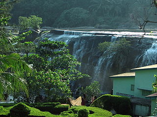
Siruvani Waterfalls and the dam named after them are located 36 km (22 mi) west of Coimbatore in the Western Ghats. The reservoir at Siruvani was built for Tamil Nadu by the Kerala government with funds collected by the Tamil Nadu government to meet the drinking water requirements of Coimbatore. The gateways on either side of the road across the dam are typical of the Kerala and Tamil architectural styles. Siruvani is also home to certain tribals like the Mudugars and Irulars. The view from the falls and the dam is a tourist attraction.
Vattaparai Falls are located at: 8°15.919′N77°27.062′E, elevation 40 m (130 ft), in the Keeriparai reserve forest near Bhoothapandi village (Pin:629852) on the Pazhayar River in Kanyakumari district, Tamil Nadu state, South India. It is 25 km (16 mi) N of Nagercoil) and 32 km (20 mi) NW of Kanyakumari. This 20 km2 (7.7 sq mi) area is proposed to be a Wildlife Sanctuary.
Thirparappu Waterfalls is located near Kulasekharam town in Kanyakumari district, Tamil Nadu state, India.

Lakkidi is a rain forest mid-lands located in the gateway of Wayanad district of the Indian state of Kerala. During British rule, a horse track through Wayanad brought European investors and traders who started cultivating Malabar pepper and spices, tea and coffee. Today the all weather road National Highway 766 connects Kozhikode in Kerala with Kollegal in Karnataka via Mysore creating business opportunities in tourism and agriculture. The viewing spot here protected by railing offers dazzling view of misty hillocks, green valleys and silvery streams at dawn. Lakkidi is surrounded by rich biodiversity and unspoiled nature which attracts those interested in bird-watching, trekking and off-road driving. Jawahar Navodaya Vidyalaya in Wayanad district is situated here.
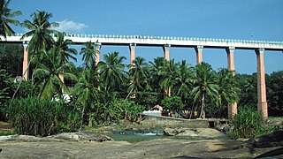
Mathoor Aqueduct or Mathoor Hanging Trough, is an aqueduct in Kalkulam taluk of Kanyakumari district of Indian state of Tamil Nadu. It is built over the Pahrali River and takes its name from Mathoor, a hamlet near the aqueduct, which is about 3 km from Thiruvattar town and about 60 km from Kanyakumari, the southernmost tip of mainland India. It is one of the longest and highest aqueducts in South Asia and is a popular tourist spot in Kanyakumari District. The nearest railway station is Kuzhithurai Railway Station which is about 15 km away and the nearest airport is the Trivandrum International Airport which is about 70 km away.

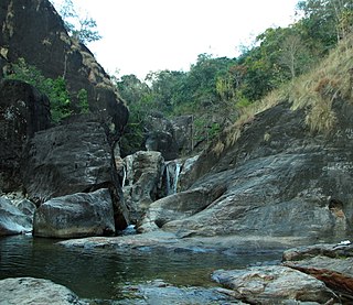
Monkey Falls are natural waterfalls located near the uphill ghat road Valparai on the Pollachi-Valparai road in the Anaimalai Hills range, in Coimbatore district.

The Pothigai Hills, also known as Agasthiyar Mountain is a 1,866-metre (6,122 ft)-tall peak in the southern part of the Western Ghats of South India. The peak lies in the border of Kerala and Tamil Nadu.
Tamil Nadu has the largest tourism industry in India with an annual growth rate of 16%. In 2015, the number of domestic arrivals was at 333.5 million making the state the most popular tourist destination in the country, and foreign arrivals numbered 4.68 million, the highest in the country, making it the most popular state for tourism in the country.
Ganapathi Sundara Natciyar Puram is a village in Virudhunagar district in the Indian State of Tamil Nadu. Located between Rajapalayam and Tenkasi on NH208. The economy is based on agriculture.
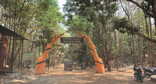
The Wayanad District of Kerala, India has a wide variety of tourist attractions ranging from religious sites to natural, and historical sites. This district is divided into three towns, Kalpetta, Sultan Bathery and Mananthavady. All Major Tourism destinations in the district are maintained by the District Tourism Promotion Council.

