The South Pennar River is a river in India. Bangalore, Hosur, Tiruvannamalai, and Cuddalore are the important cities on the banks of South Pennar river. This is the second longest river in Tamil Nadu, with a length of 497km, after the Kaveri. Chandapura, Anekal, Hosur, Bagalur and Chengam are the major industrial settlements on its banks. The river is severely polluted by industrial waste as it flows through major industrial areas in the eastern suburbs of Bangalore, Industrial parks of Hosur and Chengam.
Panruti is a developing city, municipality and taluk headquarters of Cuddalore district, Tamil Nadu, India. Panruti is located between Cuddalore and Neyveli. Panruti is famous for jackfruits and cashew nuts. The jackfruit grown here is exported worldwide and is very sweet. It is a business capital of Cuddalore district. Kananchavadi one of the villages in panruti taluk, famous for palm juice. It has been a great commercial area for more than 200 years. The name Panruti came from the Tamil words "Pann" and "Urutti" meaning "composing song and music", as the place is where many saints and great religious singers such as nayanmars and vainavas sung. A 150-year-old government school was built here by the British East India Company and a more-than-1000-year-old temple Veerattaneswarar temple is nearby in Thiruvathigai. As of 2011, the town had a population of 60,323.

Silver Beach is a beach on the southeast coast of India. It is located 2 km (1.2 mi) from downtown Cuddalore, the headquarters of Cuddalore district in the state of Tamil Nadu. Silver Beach, however, is untouched by the busy life of the city. It is the second longest beach on the Coromandel Coast and one of the longest beaches in Asia. The 57 km-long stretch of beach faces severe seafront erosion.
Alapakkam is a census town in Chengalpattu district in the state of Tamil Nadu, India. The Alapakkam Census Town has population of 9,404 of which 4,702 are males while 4,702 are females as per report released by Census India 2011.
Kattumannarkoil is a panchayat town and taluk headquarters in Cuddalore district in the Indian state of Tamil Nadu. Kattumannarkoil Town Panchayat constituted in 1892. The town is coming under the administrative territory of Cuddalore District. The town extends over an area of 19.425 km2. The town is situated along 25 km South West of Chidambaram and lies on the Chidambaram - Coimbatore Highway and 25 km East of Srimushnam and a similar distance north-east of Gangaikonda Cholapuram. The entire road route from Sethiathoppu to Kattumannarkoil runs alongside the Veeranam Lake. The newly built Muttam bridge provides connectivity to Mayladuthurai in the south at the distance of 30 km.
Marakkanam is a coastal panchayat town & Taluk in Viluppuram district in the Indian state of Tamil Nadu. It is well connected to the state capital Chennai and the nearby union territory of Puducherry by the East Coast Road. To the west, Marakkanam is connected to the town of Tindivanam by the SH-134. Marakkanam is situated on the declared National Waterways NW-4. On materialisation of National Waterways NW-4, Marakkanam will be connected to two states Andhra Pradesh (Kakinada) and Puducherry through north and south of Buckingham Canal.
Minjur is a town located in the outskirts of North Chennai, India. It is located in the Thiruvallur district in the Indian state of Tamil Nadu. Minjur is called 'Vada Kanchi' meaning North Kanchipuram. The town has two famous temples for Shiva and Vishnu, similar to Kanchipuram. The neighbourhood is served by Minjur railway station of the Chennai Suburban Railway Network.
Bhuvanagiri is a Taluka in the Cuddalore district of the Indian state of Tamil Nadu. It is the birthplace of a South Indian saint, Sri Raghavendra Swami and is close to Maruthur, the birthplace of Saint Ramalinga Adigalar.
The Lytton First Nation, a First Nations band government, has its headquarters at Lytton in the Fraser Canyon region of the Canadian province of British Columbia. While it is the largest of all Nlaka'pamux bands, unlike all other governments of the Nlaka'pamux (Thompson) people, it is not a member of any of the three Nlaka'pamux tribal councils, which are the Nicola Tribal Association, the Fraser Canyon Indian Administration and the Nlaka'pamux Nation Tribal Council.

The Gadilam River flows through the Cuddalore and Villupuram districts of Tamil Nadu.
Alapakkam also called is a village in Cuddalore district in Tamil Nadu. It comes under Cuddalore taluk and Alappakkam and poovanikuppam village panchayat. It is located on highway NH 45A, en route to Chidambaram. It is 19 km from Cuddalore and 29 km from Chidambaram town. Perumal lake is located the poovanikuppam panchayat The village consists of more than 1,000 acres (4.0 km2) of arable land and about 1000 homes. The village also houses an ancient Shiva temple. It has one middle school and one elementary school.the lake water finally connected to sangolikuppam river.alappkkam village located inside the keezhpoovanikuppam village panchayat.
Alapakkam is a neighbourhood in western part of Central Chennai. It belongs to Central Chennai Revenue Division of Chennai district. It is surrounded by Porur, Valasaravakkam and Maduravoyal. It is part of Chennai corporation under zone 11. Entry in to Alapakkam is through two main roads, that is, Arcot Road and Poonamallee High Road. Alapakkam belongs to Sriperumbudur Lok Sabha constituency and Maduravoyal assembly constituency.
The Taku River Tlingit First Nation are the band government of the Inland Tlingit in far northern British Columbia, Canada and also in Yukon. They comprise two ḵwaan (tribes) of the Tlingit people, who are otherwise coastal, the Áa Tlein Ḵwáan of the Atlin Lake area and the Deisleen Ḵwáan of Teslin Lake, whose main focus is the Teslin Tlingit Council in Teslin, Yukon. Their band offices are in Atlin, British Columbia.
Thudupathi is a town in the taluk of Perundurai in the district of Erode in Tamil Nadu, India. The distance between Perundurai and the village is 5 kilometers and from NH47 it is 2.5 kilometers. It is the site of S.Samy Sound Service & Decorators and Erode Sengunthar Engineering College. There are government elementary and Higher secondary school located which has a proud of producing District level rank holders every year. Below are the list of students who achieved this milestone so far, 1. Gokulakrishnan - HSC District 3rd rank holder 2. Vijayakumar - SSLC District 1st rank holder 3. Kathiravan - HSC District 1st rank holder 4. Madhankumar - HSC District 1st rank holder 5. Vijayakumar - HSC District 2nd rank holder This village holds an ancient Perumal temple. There are engineering colleges, medical colleges, auditing colleges located around this village.
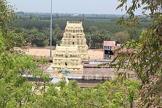
Devanathaswamy temple in Thiruvanthipuram, a village in the outskirts of Cuddalore in the South Indian state of Tamil Nadu, is dedicated to the Hindu god Vishnu. Constructed in the Dravidian style of architecture, the temple is glorified in the Divya Prabandha, the early medieval Tamil canon of the Azhwar saints from the 6th–9th centuries CE. It is one of the 108 Divyadesam dedicated to Vishnu, who is worshipped as Devanathaswamy and his consort Lakshmi as Hemabhujavalli. Though the presiding deity is Devanathaswamy, the temple is known for Hayagriva, the horse faced avatar of Vishnu, God of Knowledge. The temple is the only historical temple in South India to have a shrine of Hayagriva on hilltop.
Ikkadu Kandigai is a village near Tiruvallur town in the Indian state of Tamil Nadu. It is five kilometers from Tiruvallur town. The population is around 400 families. It is covered by fully cultivated lands.

Annan Koil is a village near Sirkazhi in Mayiladuthurai district of Tamil Nadu,. The main occupation of the people is agriculture. The soil is alluvial and the village is well irrigated by the river Kaveri which flows into the Bay Of Bengal.
Bahour is a town, Commune, Taluk and Assembly Constituency in the Union Territory of Puducherry, India. It consists of four non-contiguous areas, including three of the nine true enclaves of Puducherry. It is home to the second largest and perhaps the oldest irrigation lake in the region- the Bahour Eri. The lake has been in existence since the Chola period. Bahour also has reports of lignite deposits but it is not exploited due to its close proximity to the sea and the likelihood of seeping seawater, adulterating the ground water. It is a major access point for villages south of Puducherry and forms the southern border to the Union territory. The city is also known as the ‘rice bowl of Puducherry’ since the area is suitable for Paddy (rice) cultivation.
Meladhanur is a village located in Tittakudi taluk, Cuddalore district in the state of Tamil Nadu, India. Tittakudi is the nearest town for this village and the Trichy to Chennai highway (NH45) is the nearest one.
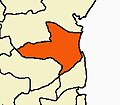
Kallakurichi is one of the 38 districts in the state of Tamil Nadu in India. The district headquarter is Kallakurichi. Kallakurichi District was announced on 8 January 2019 and it came into existence on 26 November 2019.