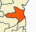
Parangipettai block is a revenue block of Cuddalore district of the Indian state of Tamil Nadu. [1] This revenue block consist of 41 panchayat villages. [2] The Regional Development Office of this municipal union is functioning at Parangipettai.
According to the 2011 Census of India, the total population of Parangipettai Panchayat Union is 1,10,073. The number of Scheduled Caste population is 33,939. The number of Scheduled Tribes is 1,030. [3]
SI.No | Panchayat Village |
---|---|
1 | Adivaraganallur |
2 | Ariakoshti |
3 | Arunmozhidevan |
4 | Ayeepuram |
5 | B.Maduvangarai |
6 | B.Mutlur |
7 | C.Kothankudi |
8 | Chinnakomatti |
9 | Chinnur Pudupettai |
10 | Kanagarapattu |
11 | Kavarapattu |
12 | Keel Anuvampattu |
13 | Keelamanakudi |
14 | Keelaperambai |
15 | Keelathirukalipalai |
16 | Kothattai |
17 | Kovilampoondi |
18 | Kumaramangalam |
19 | Kuriyamangalam |
20 | Manikollai |
21 | Manjakuzhi |
22 | Meethikudi |
23 | Melathirukalipalai |
24 | Nakkaravandankudi |
25 | Nanjamahathuvalgai |
26 | Pallipadai |
27 | Periyakomatti |
28 | Periyapattu |
29 | Pichavaram |
30 | Pinnathur |
31 | Poovalai |
32 | Senthirakillai |
33 | Silambimangalam |
34 | Thandavarayasozhanpet |
35 | Thatchakadu |
36 | Thillaividangan |
37 | Uthamasozhamangalam |
38 | Vasaputhur |
39 | Vayalamoor |
40 | Velangipattu |
41 | Villiyanallur |
Panruti is a town, municipality and taluk headquarters of Cuddalore district, Tamil Nadu, India. Panruti is located between Cuddalore and Neyveli. Panruti is famous for jackfruits and cashew nuts. The jackfruit grown here is exported worldwide and is very sweet. It is a business capital of Cuddalore district. Kananchavadi one of the villages in panruti taluk, famous for palm juice. It has been a great commercial area for more than 200 years. The name Panruti came from the Tamil words "Pann" and "Urutti" meaning "composing song and music", as the place is where many saints and great religious singers such as nayanmars and vainavas sung. A 150-year-old government school was built here by the British East India Company and a more-than-1000-year-old temple Veerattaneswarar temple is nearby in Thiruvathigai. As of 2011, the town had a population of 60,323.
Cuddalore District is one of the 38 districts in the state of Tamil Nadu in India.
Killai is a second-grade panchayat town in the Chidambaram taluk of the Cuddalore district of Tamil Nadu, India.
Parangipettai, historically called Porto Novo, is a coastal panchayat town in Cuddalore district in the Indian state of Tamil Nadu. Parangipettai is located on the north bank of the mouth of the Vellar River at a distance of 30 km from Cuddalore. From the state capital city of Chennai, Parangipettai can be reached through the National Highway NH32 stretch between Cuddalore and Chidambaram.
The Puducherry district, also known by its former name Pondicherry district, is one of the four districts of the union territory of Puducherry in South India. The district occupies an area of 290 square kilometres (110 sq mi), spread over 12 non-contiguous enclaves lying on or near the Bay of Bengal within a compact area in the state of Tamil Nadu. According to the 2011 census, the district has a population of 950,289.
Thalaivasal is a town and Taluk in the Salem district of Tamil Nadu, India. It is located 18 km away from the Sub-district headquarter Attur and 70 km away from the Salem District Headquarter. It is one of the Taluks of the Salem District
Tufanganj-II is a community development block that forms an administrative division in Tufanganj subdivision of Cooch Behar district in the Indian state of West Bengal.
Annagramam block is a revenue block of Cuddalore district of the Indian state of Tamil Nadu. This revenue block consist of 42 panchayat villages.
Bhuvanagiri block is a revenue block of Cuddalore district of the Indian state of Tamil Nadu. This revenue block consist of 47 panchayat villages.
Cuddalore block is a revenue block of Cuddalore district of the Indian state of Tamil Nadu. This revenue block consist of 51 panchayat villages.
Kattumannarkoil block is a revenue block of Cuddalore district of the Indian state of Tamil Nadu. This revenue block consist of 55 panchayat villages.Total area of Kattumannarkoil is 455 km2 including 406.38 km2 rural area and 48.74 km2 urban area.Kattumannarkoil has a population of 2,76,947 peoples. There are 67,752 houses in the sub-district. There are about 147 villages in Kattumannarkoil block.
Keerapalayam block is a revenue block of Cuddalore district of the Indian state of Tamil Nadu. This revenue block consist of 63 panchayat villages.
Komaratchi block is a revenue block of Cuddalore district of the Indian state of Tamil Nadu. This revenue block consist of 57 panchayat villages.
Mangalur block is a revenue block of Cuddalore district of the Indian state of Tamil Nadu. This revenue block consist of 67 panchayat villages. It is the biggest block in Cuddalore district.
Nallur block is a revenue block of Cuddalore district of the Indian state of Tamil Nadu. This revenue block consist of 64 panchayat villages.
Panruti block is a revenue block of Cuddalore district of the Indian state of Tamil Nadu. This revenue block consist of 42 panchayat villages.
Galsi I is a community development block that forms an administrative division in Bardhaman Sadar North subdivision of Purba Bardhaman district in the Indian state of West Bengal.
Pettai is a village in the southern state of Tamil Nadu, India. Administratively, Parangipettai is under the Chidambaram Taluk of Cuddalore District, Tamil Nadu. In the 2011 census 469 people were reported as living in Parangipettai.
The Malappuram district has four types of administrative hierarchies:
Thiruvennainallur taluk is one of the 9 taluks of Viluppuram district in the Indian state of Tamil Nadu.
{{cite web}}
: CS1 maint: archived copy as title (link)