Wellington Lake

Last updated

Wellington Lake
India Tamil Nadu relief map.svg
Red pog.svg
Wellington Lake
Location Cuddalore district, Tamil Nadu, India
Coordinates 11°20′10″N79°32′40″E / 11.33611°N 79.54444°E / 11.33611; 79.54444
Type Reservoir, intermittent
Basin  countries India

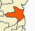
Wellington Lake is a lake situated in the Keelachiruvoi to Ivanur Villages,(Near Tittakudi) Tittakudi taluk of the Cuddalore district in the Indian state of Tamil Nadu. It is the second-largest lake in Tamil Nadu after the Veeranam Lake, which also is situated in the Cuddalore district. [1]

It is primarily a rain-fed lake, while its main tributary is the Vellar River that originates from the Shevaroy Hills. Smaller creeks that originate from the Nangoor reserve forest and the Lakkur reserve forest form the secondary tributaries.[ citation needed ]

The Wellington Lake also has about 27 ancillary lakes [2] and together they form the primary source of irrigation for nearly 25,000 acres (10,000 hectares) of land and over 67 villages dependent on it for cultivation.[ citation needed ]

The lake is also a noted trout fishery and home to a small-scale inland fishing industry. [2]

Related Research Articles

<span class="mw-page-title-main">Noyyal River</span> River in India

The Noyyal River is a small river in Western Tamil Nadu, and a tributary of Kaveri River. It rises from the Vellingiri hills in the Western Ghats in Tamil Nadu, very closer in proximity to Kerala border, and flows through many villages and the cities of Coimbatore, and Tirupur. Then finally, the river drains into the Kaveri River at Noyyal, a village in Karur district named after the river itself. The river's basin is 180 km (110 mi) long and 25 km (16 mi) wide and covers a total area of 3,500 km2 (1,400 sq mi). Cultivated land in the basin amounts to 1,800 km2 (690 sq mi) while the population density is 120 people per km² (311/mi²) in the countryside, and 1000 people per km² (2590/mi²) in the cities. The area is known for its scanty rainfall and the development of the Noyyal River Tanks System to hold any overflow from the rains plus the water of the Northeast and Southwest monsoon season was ecologically important. Kausika river, which originates along the northern side of Coimbatore district in the Western Ghats along with its consequent streams, lake and pond systems is an important tributory of the river. The 173 km (107 mi) long tributary of the Kaveri River filled 32 tanks. These interconnecting tanks held the water flowing from the Noyyal.

<span class="mw-page-title-main">Ponnaiyar River</span> River in southern India

The South Pennar River is a river in India. Bangalore, Hosur, Krishnagiri,Kaveripattinam, and Cuddalore are the important cities on the banks of South Pennar river. This is the second longest river in Tamil Nadu, with a length of 497 km, after the Kaveri. Chandapura, Anekal, Hosur, Bagalur, and Chengam are the major industrial settlements on its banks. The river is severely polluted by industrial waste as it flows through major industrial areas in the eastern suburbs of Bangalore, Industrial parks of Hosur and Chengam.

<span class="mw-page-title-main">Periyar River</span> River in Kerala, India

Periyar, IPA: [peɾijɐːr], is the longest river and the river with the largest discharge potential in the Indian state of Kerala. It is one of the few perennial rivers in the region and provides drinking water for several major towns. The Periyar is of utmost significance to the economy of Kerala. It generates a significant proportion of Kerala's electrical power via the Idukki Dam and flows along a region of industrial and commercial activity. The river also provides water for irrigation and domestic use throughout its course besides supporting a rich fishery. Due to these reasons, the river has been named the "Lifeline of Kerala". Kochi city, in the vicinity of the river mouth draws its water supply from Aluva, an upstream site sufficiently free of seawater intrusion. Twenty five percent of Kerala's industries are along the banks of river Periyar. These are mostly crowded within a stretch of 5 kilometres (3 mi) in the Eloor-Edayar region (Udhyogamandal), about 10 kilometres (6 mi) north of Kochi harbor.

<span class="mw-page-title-main">Anaimalai Hills</span> Mountain range in India

The Anamala or Anaimalai, also known as the Elephant Mountains, are a range of mountains in the southern Western Ghats of central Kerala and span the border of western Tamil Nadu in Southern India. The name anamala is derived from the Malayalam word aana and the Tamil word yaanai, meaning elephant, or from tribal languages. Mala or Malai means 'mountain', and thus literally translatable as 'Elephant mountain'.

<span class="mw-page-title-main">Cuddalore district</span> District of Tamil Nadu in India

Cuddalore District is one of the 38 districts in the state of Tamil Nadu in India.

<span class="mw-page-title-main">Kattumannarkoil</span> Panchayat town in Tamil Nadu, India

Kattumannarkoil is a panchayat town and taluk headquarters in Cuddalore district in the Indian state of Tamil Nadu. Kattumannarkoil Town Panchayat constituted in 1892. The town is coming under the administrative territory of Cuddalore District. The town extends over an area of 19.425 km2. The town is situated along 25 km South West of Chidambaram and lies on the Chidambaram - Coimbatore Highway and 25 km East of Srimushnam and a similar distance north-east of Gangaikonda Cholapuram. The Place is considered as the birth place of one of the great Vaishnavate Acharya Nathamuni and Yamunacharya. As Lord Vishnu came here as King ‘Mannan’ to hold the hand of Mahalakshmi; and later asked Nathamunigal to share the Divya Prabandham and the Vaishnava Sampradayam to the world at large, he was referred to as ‘ Kattum – Mannan – Aanaar’ and the town later became Kattu Mannar. The place historic name was Veeranarayanapuram.

Tittakudi is a Municipality and taluk headquarters in Cuddalore district in the Indian state of Tamil Nadu. Tittakudi itself is the Tittakudi Member of Assembly Constituency. Tittakudi is the reserved Constituency.

<span class="mw-page-title-main">East Coast Road</span> Road in Tamil Nadu, India

East Coast Road (ECR), combination of SH-49, NH-332A, NH-32, officially known as Mutthamizh Arignar Kalaignar Road, is a two-lane highway in Tamil Nadu, India, built along the coast of the Bay of Bengal connecting Tamil Nadu's state capital city Chennai with Kanyakumari via Puducherry, Cuddalore, Chidambaram, Sirkali, Thirukkadaiyur, Tharangambadi, Karaikal, Nagore, Nagapattinam, Thiruthuraipoondi, Muthupet, Adirampattinam, Manora, Manamelkudi, Mimisal, Ramanathapuram, Thoothukudi, Tiruchendur, Uvari, Kudankulam. The total length of the road is about 777 km between Chennai and Kanyakumari.

<span class="mw-page-title-main">Kalakkad Mundanthurai Tiger Reserve</span> Tiger reserve in Tamil Nadu, India

Kalakkad Mundanthurai Tiger Reserve (KMTR) located in the South Western Ghats montane rain forests in Tirunelveli district and Kanyakumari district in the South Indian state of Tamil Nadu, is the second-largest protected area in Tamil Nadu. It is part of the Agasthyamala Biosphere Reserve.

<span class="mw-page-title-main">Veeranam Lake</span> Man-made lake in Tamil Nadu, India

Veeranam Lake is located 14 km (8.7 mi) SSW in Cuddalore district in the state of Tamil Nadu in South India 1 km from Kattumannarkoil. It is located 235 km (146 mi) from Chennai, India. It is one of the water reservoirs from where water is supplied to Chennai city. The lake has a capacity to store about 1,465 mcft of water. Though the level in the Veeranam lake has dipped to 323 million cubic feet (mcft), the same amount of 180 mld was being drawn for supply to Chennai City.

<span class="mw-page-title-main">Vellar River (Northern Tamil Nadu)</span> River in Tamil Nadu, India

The Vellar River is a river in the Indian state of Tamil Nadu. It originates in the Kalrayan Hills, and flows generally eastward through Salem, Perambalur, and Cuddalore districts, before flowing into the Bay of Bengal near Parangipettai. The river has a total length of 150 kilometres (93 mi), and its drainage basin covers an area of 7,504.346 square kilometres (2,897.444 sq mi) in Cuddalore, Perambalur, Salem, Kallakurichi, Ariyalur, Namakkal, Tiruchirappalli, and Dharmapuri districts.

Thozhudur,, are twin towns decorated by Vellar River in Cuddalore District, Tamil Nadu, India.

Karaimedu is a revenue village in Cuddalore district, state of Tamil Nadu, India. Karaimedu is a small village, which is 2.5 km away from Bahour with more than one hundred families lives there. The village is situated in the southern border of Bahour lake.

Kaiperambalur is a panchayat village of the Kizhamathdur district in Perambalur, Tamil Nadu, India. It was formally part of the Tiruchirappalli district.

<span class="mw-page-title-main">Ganapathikurichi</span>

Ganapathikurichi is a village of Nallur Panchayat union in Tittakudi taluk, Cuddalore district, Tamil Nadu. It is a well developed and unimpeachable agricultural village and most of peoples are farmers. It has a mariyamman and draupadi temple & a village health center. The village is known for cashews and sugarcanes.

Meladhanur is a village located in Tittakudi taluk, Cuddalore district in the state of Tamil Nadu, India. Tittakudi is the nearest town for this village and the Trichy to Chennai highway (NH45) is the nearest one.

Alambadi is a village panchayat in Cuddalore district in the Indian state of Tamil Nadu. It is located inside from 2 km of the National Highway NH-45 which is from Avatti X Road Bus Stop to Alambadi has 2 km. Whole 2 km road with fully surrounded by tamarind trees (புளியமரம்). And this village will comes under Tittagudi Taluk as well as constitution.

Ramanatham and Tholudur or Thozhudur,, are twin towns by the Vellar River in Cuddalore District, Tamil Nadu, India.

<span class="mw-page-title-main">Vellar River (Southern Tamil Nadu)</span> River in Tamil Nadu, India

The Vellar River or South Vellar River is a non-perennial river in the Indian state of Tamil Nadu that flows southeast into the Palk Strait, part of the Bay of Bengal.

C. V Ganesan is an Indian politician from the Dravida Munnetra Kazhagam (DMK). He was elected twice as a member of the Tamil Nadu Legislative Assembly from Tittakudi. Since May 2021, he is serving as Tamil Nadu's Minister for Labour Welfare and Skill Development.

References

  1. "Tehsil Tittakudi of district Cuddalore, Tamil Nadu".
  2. 1 2 "AIADMK" . Retrieved 23 June 2013.