
Aksai Chin is a region administered by China as part of Hotan County, Hotan Prefecture, Xinjiang and Rutog County, Ngari Prefecture, Tibet. It is claimed by India to be a part of its Leh District, Ladakh Union Territory. It is a part of the eastern portion of the Kashmir region and has been a subject of dispute between India and China since the late 1950s.
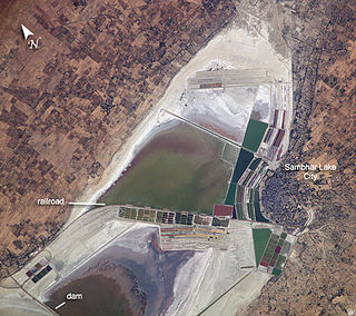
The Sambhar Salt Lake, India's largest inland salt lake, is located in Sambhar Lake Town, Jaipur district of Rajasthan, India, 80 km (50 mi) southwest of the city of Jaipur and 64 km (40 mi) northeast of Ajmer, Rajasthan. It surrounds the historical Sambhar Lake Town.

Vembanad is the longest lake in India, as well as the largest lake in the state of Kerala. The lake has an area of 230 square kilometers and a maximum length of 96.5 km. Spanning several districts in the state of Kerala, it is known as Vembanadu Lake in Kottayam, Vaikom, Changanassery, Punnamada Lake in Alappuzha, Punnappra, Kuttanadu and Kochi Lake in Kochi. Several groups of small islands including Vypin, Mulavukad, Maradu, Udayamperoor, Vallarpadam, Willingdon Island are located in the Kochi Lake portion. Kochi Port is built around the Willingdon Island and the Vallarpadam island.
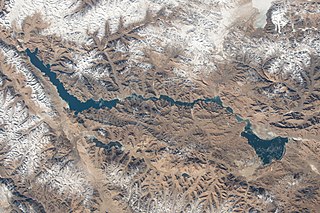
Pangong Tso or Pangong Lake is an endorheic lake spanning eastern Ladakh and West Tibet situated at an elevation of 4,225 m (13,862 ft). It is 134 km (83 mi) long and divided into five sublakes, called Pangong Tso, Tso Nyak, Rum Tso and Nyak Tso. Approximately 50% of the length of the overall lake lies within Tibet in China, 40% in Ladakh, India and the remaining 10% is disputed and is a de-facto buffer zone between India and China. The lake is 5 km (3.1 mi) wide at its broadest point. All together it covers almost 700 km2. During winter the lake freezes completely, despite being saline water. It has a land-locked basin separated from the Indus River basin by a small elevated ridge, but is believed to have been part of the latter in prehistoric times.
Pookode Lake is a scenic freshwater lake in the Wayanad district in Kerala, South India. A major tourist destination in the district, Pookode is a natural freshwater lake nestling amid evergreen forests and mountain slopes at an elevation of 770 meters above sea level. It is 15 km away from Kalpetta. It is the smallest and highest elevation freshwater lake in Kerala.
Rangamati Hill District (Chakma:𑄢𑄋𑄟𑄖𑄴𑄳𑄠 ;) is a district in south-eastern Bangladesh. It is a part of the Chattogram Division, and the town of Rangamati serves as the headquarters of the district. By area, Rangamati is the largest district of the country.

Bidhannagar is a planned urban agglomeration in the Indian state of West Bengal, and a satellite township of Kolkata. It falls in Greater Kolkata region and currently falls under the administration of the Bidhannagar Municipal Corporation. Keeping with its original name, it is commonly referred to as Salt Lake City, and was planned and developed between 1958 and 1965 to accommodate the burgeoning population of Kolkata.

The Jaldhaka River (Pron:/ˌdʒælˈdɑːkə/), also known as Dichu, a tributary of Brahmaputra is a trans-boundary river flowing through India, Bhutan and Bangladesh with a length of 233 kilometres. It originates from the Bitang Lake at Kupup, Gangtok District, Sikkim, near the Jelep La pass below Dongkya Mountain Range. It flows through Pakyong District of Sikkim, India and then passes through forests of Samtse District of Bhutan where it flows for around 40 Kilometres and than re-enters India at Bindu, Kalimpong district. Further it passes through West Bengal's cities and towns like Dhupguri, Falakata, Mathabhanga and flows through Kalimpong, Jalpaiguri and Cooch Behar districts in West Bengal, India. Than the river enters Bangladesh at Mogolhat, Lalmonirhat District of Rangpur Division. It is known as Dharla River in Bangladesh and flows through towns like Kolaghat, Phulbari and Kurigram City and Passes southwards until the Dharla debouches into the Brahmaputra River at Bagua Anantpur of Kurigram District. Due to the river's wandering over several international borders, only a small length of the river lies in Bangladesh and Bhutan and most of its path lies in India. In some places, this river is also known as Mansai river and Singhimari river.

Gobardanga is a city and a municipality in North 24 Parganas district in the Indian state of West Bengal. Founded on 20 April 1870, it is one of the oldest municipalities of West Bengal.

Gurudongmar Lake is one of the highest lakes in the world and in India, at an elevation of 5,430 m (17,800 ft) according to the Government of Sikkim. It is located in the Great Himalayas in the Mangan District in Indian state of Sikkim, and considered sacred by Buddhists, Sikhs and Hindus. The lake is named after Guru Padmasambhava—also known as Guru Rinpoche—founder of Tibetan Buddhism, who visited in the 8th century.
Elur Chetty is a [Tamil/ Malayalam] speaking Hindu community in South India. They are said to have migrated from Kaveripoompattanam in Thanjavur District and settled in Kanyakumari District. They come under the common name of Chetty which includes other communities such as Kottar Chetty, Parakka Chetty, Vellalar Chetty, Pathira Chetty, Valayal Chetty, Pudukottai vallanattu Chetty, Nattukkottai Chetty etc. They were once a trading community and were distinct from the other Chetty communities. The name is derived from "Ezhu ooru" meaning "seven towns". The seven towns were in and around the Kanyakumari District in South Tamil Nadu, India, namely Eraniel, Thiruvithancode, Padmanabhapuram, Colachel, Ganapathipuram, Midalam, and Parakkai. They are called Keezhatheru Chetty. Later Kottar, Thiruvananthapuram, Therusanamkoppu, Nagercoil, Chennai, Thalakkulam, Eraniel (Melatheru), Tiruchchirappalli, Coimbatore and Madurai.
Rezang La, also called Rechin La , is a mountain pass on the Line of Actual Control between Indian-administered Ladakh and the Chinese-administered Spanggur Lake basin that is also claimed by India. The pass is located on the eastern watershed ridge of the Chushul Valley that China claims as its boundary. It is at the head of the Rezang Lungpa valley, which houses a stream draining into the Spanggur Lake.

Devikulam is a Grama Panchayat and small hill station of about 8 kilometres (5.0 mi) from Munnar in the Idukki District of Kerala State, India. It lies 1,800 metres (5,900 ft) above sea level.

Sasthamcotta Lake or Sasthamkotta Lake, also categorized as a wetland, is the largest fresh water lake in Kerala, a state of India on the south of the West Coast. The lake is named after the ancient Sastha temple located on its bank. It meets the drinking water needs of half million people of the Quilon district and also provides fishing resources. The purity of the lake water for drinking use is attributed to the presence of large population of larva called cavaborus that consumes bacteria in the lake water. The lake is a designated wetland of international importance under the Ramsar Convention since November 2002.
Marsimik La or Marsemik La, also called Lankar La, elevation 5,582 metres (18,314 ft) is a high mountain pass in the Chang Chenmo Range in the Indian union territory of Ladakh, 96 km (60 mi) east of Leh as the crow flies. Ladakh's route to the Chang Chenmo Valley traverses the pass.

Madiwala lake is one of the biggest lakes in Bangalore, India spread over an area of 114.3 hectare. Legend has it that the lake was built by the Cholas in a day. The water in the lake was fit for drinking till the early 1990s. Since then it has become unfit for drinking due to industrial waste and sewage entering the waterbody. It has gradually become polluted.

Tilyar Lake is one of the major tourist attractions in the Indian state of Haryana. It is 70 kilometers from New Delhi on the Delhi – Fazilka highway and is located close to the city of Rohtak in Haryana.
Rajakkamangalam is a block or Panchayat Union of Kanyakumari district, India. It is one of the nine administrative divisions of the district of Kanyakumari. The current president of the Rajakkamangalam Panchayat is R.Ayyappan. It includes the following 15 village panchayats,
- Athikkattuvilai
- Elluvilai
- Ganapathipuram
- Kanyakulam
- Kesavanputhenthurai
- Melekrishnanputhoor
- Manakudi
- Northsoorankudy
- Putheri
- Peruvilai
- Parakkai
- Pallamthurai
- Melasankarankuzhi
- Rajakkamangalam Thurai
- Dharmapuram
- Azhathangarai
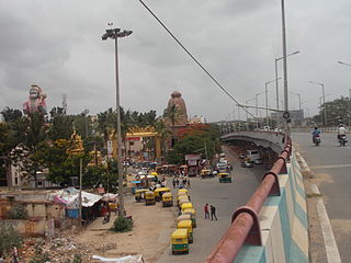
Agara Bangalore is a panchayat village in the southern state of Karnataka, India. It is located in the Bangalore South taluk of Bangalore Urban district in Karnataka, on Outer Ring Road, near Koramangala and HSR Layout. The Agara Bus Stop connects Koramangla with ITPL, Varthur, etc. Agara is visited for its Oriyan temple, Agara Lake, Ayyappa Temple & Aanjaneya Temple. After winning the Sreerangapattana war, the British moved their army to Banaglore. In British times, it was one of the biggest army cantonments in south Asia. Madras Engineer Groups was operating from Agara.

The Khurnak Fort is a ruined fort on the northern shore of the Pangong Lake that spans eastern Ladakh in India and Rutog County in the Tibet region of China. The area of the Khurnak Fort is disputed by India and China, and has been under Chinese administration since 1958.
