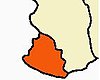
Sharavati is a river which originates and flows entirely within the state of Karnataka in India. It is one of the few westward flowing rivers of India and a major part of the river basin lies in the Western Ghats. The famous Jog Falls, located about 25 km from Siddapura, is formed by this river. The river itself and the regions around it are rich in biodiversity and are home to many rare species of flora and fauna.

The Mettur Dam is one of the largest dams in India and also the largest in Tamil Nadu, located across the river Kaveri where it enters the plains. Built in 1934, it took nine years to complete. Maximum height and width of the dam are 214 and 171 feet, respectively. The dam receives inflows from its own catchment area, Kabini Dam and Krishna Raja Sagara Dams located in Karnataka. There is a park at the base of the dam. It provides irrigation and drinking water facilities for more than 12 districts of Tamil Nadu and hence is revered as the life and livelihood-giving asset of Tamil Nadu.
Pothundi Dam is an irrigation dam near Pothundi village in the Palakkad district of Kerala state, India. Constructed in the 19th century, it is considered one of the oldest dams in India. It provides irrigation to an area of 5,470 hectares in the Palakkad district and drinking water supply to the Nemmara, Ayalur, Melarcode Panchayat. An unusual feature of the earth dam is the core wall, which is built with a mixture of jaggery and quick lime.

Nizam Sagar Dam is an Indian dam named after the Nizam of Hyderabad. It is a reservoir constructed across the Manjira River, a tributary of the Godavari River, between Achampet and BanjePally villages of the Kamareddy district in Telangana, India. It is located at about 144 km (89 mi) north-west of Hyderabad. Nizam Sagar is the oldest dam in the state of Telangana.

Nagarjuna Sagar Dam is a masonry dam across the Krishna River at Nagarjuna Sagar which straddles the border between Palnadu district in Andhra Pradesh and Nalgonda district in Telangana. The dam provides irrigation water to the districts of Krishna, Guntur, Palnadu, Prakasam and parts of West Godavari districts of Andhra Pradesh and also Nalgonda, Suryapet, Khammam, Bhadradri Kothagudem districts of Telangana. It is also a source of electricity generation for the national grid.

The Shoshone Project is an irrigation project in the U.S. state of Wyoming. The project provides irrigation for approximately 107,000 acres (430 km2) of crops in the Big Horn Basin, fulfilling the vision of local resident and developer Buffalo Bill Cody, who hoped to make the semi-arid basin into agricultural land. Buffalo Bill Dam on the Shoshone River impounds water for the project in Buffalo Bill Reservoir. In addition to its role in irrigation, the project provides flood control on the Shoshone and generates power, using the 350-foot (110 m) height of Buffalo Bill Dam, once a world record, and the considerable fall of the river through Shoshone Canyon to generate hydroelectric power. Chief crops in the Big Horn Basin are sugar beets, alfalfa, barley, oats, corn and beans.
Ghataprabha is a village in the north of the Indian state of Karnataka. It is located in the Gokak taluk of Belgaum district in Karnataka.
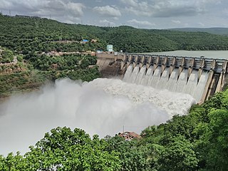
The Srisailam Dam is constructed across the Krishna River in Nandyal district, Andhra Pradesh and Nagarkurnool district, Telangana near Srisailam temple town and is the 2nd largest capacity working hydroelectric station in India.

River Vamsadhara or River Banshadhara is an important east flowing river between Rushikulya and Godavari, in Odisha and Andhra Pradesh states in India.

Jayakwadi dam is an earthen dam located on Godavari river at the site of Jayakwadi village in Paithan taluka of Aurangabad district in Maharashtra, India. It is a multipurpose project. The water is mainly used to irrigate agricultural land in the drought-prone Marathwada region of the state. It also provides water for drinking and industrial usage to nearby towns and villages and to the municipalities and industrial areas of Sambhajinagar and Jalna districts. The surrounding area of the dam has a garden and a bird sanctuary.

Perunchani Dam is an irrigation dam at Perunchani, Kanyakumari District, in the state of Tamil Nadu, India. It is one of the dams of the Kodayar Irrigation System. As there was water deficiency in the Kodayar Irrigation System, Perunchani Dam was constructed in December 1952 to store flood water of the Paralayar River as an extension. It was built about 1 km (0.62 mi) upstream of the Puthen dam on the Paralayar River. The irrigation system became operational on 2 September 1953. It feeds the left bank irrigation canal system of the Puthen dam, which is the terminal structure of the system.

The Dahla Dam, also known as Arghandab Dam and Kasa, is located in the Shah Wali Kot District of Kandahar Province in Afghanistan, approximately 40 km (25 mi) northeast of the provincial capital Kandahar. Its name derives from Dahla, which is the historical name of the area where the dam was built. It is the second largest dam in Afghanistan after the Kajaki Dam in neighboring Helmand Province. In 2019, the Afghan government planned to spend $450 million in upgrading the dam. The project includes raising the dam's walls by around 13 meters so the reservoir could hold nearly a billion cubic meters of fresh water and installing three turbines to produce 22 megawatts (MW) of electricity.

Dhom Dam is an earthfill and gravity dam on Krishna River near Wai in state of Maharashtra in India.

The Upper Wardha Dam is an earthfill straight gravity dam across the Wardha River, a tributary of the Godavari River, near Simbhora village in Morshi taluk in Amravati district in the Indian state of Maharashtra. The dam provides multipurpose benefits of irrigation, drinking water supply, flood control and hydropower generation.

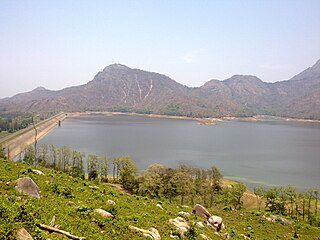
The Bhadra Dam or Lakkavalli Dam, which has created the Bhadra Reservoir, is located on the Bhadra River a tributary of Tungabhadra River. Bhadra Dam is located in the border of Bhadravathi and Tarikere, in the western part of Karnataka in India. The benefits derived from the reservoir storage are irrigation with gross irrigation potential of 162,818 hectares, hydro power generation of 39.2 MW, drinking water supply and industrial use. The dam commissioned in 1965 is a composite earth cum masonry structure of 59.13 metres (194.0 ft) height with length of 1,708 metres (5,604 ft) at the crest level, which submerges a land area of 11,250.88 hectares.

Bheema lift irrigation project or Rajiv Bheema Project is a lift irrigation canal project located in Narayanpet district in Telangana, India. Water is lifted at Panchdev Pahad from the back waters of Jurala Dam. Under the same project, another lift canal originates separately from the Ramanpahad balancing reservoir under Jurala left bank to irrigate the uplands.

The Pazhassi Dam also called Kulur Barrage is a stone masonry diversion structure in Kannur district, Kerala, India. It is named after king Pazhassi Raja, a patriot who died a heroic death in the war. The dam is constructed across the west flowing Bavali river near Veliyambra. It was commissioned by Prime Minister Morarji Desai in 1979. It mainly functions as an irrigation dam, serving a command area of 11,525 hectares in Iritty taluk of the Kannur District. The water from this dam also meets the drinking water requirement of Kannur district. The dam site and the reservoir are known for their scenery.
Kunderipallam Dam is a dam located in Kongarpalayam, Gobichettipalayam Taluk, Erode district, Tamil Nadu, India. Located in the southern part of a dense hill forest, it is a crucial structure for Tamil Nadu's agricultural and hydroelectric power sectors. In addition, it is valuable as a destination for international tourism due to the wide variety of both rare fish and fowl that call it home.
Lower Manair Dam also known as LMD was constructed across the Manair River, at Alugunur village, Thimmapur mandal, Karimnagar District, in the Indian state of Telangana during 1974 to 1985. It provides irrigation to a gross command area of 163,000 hectares.

The Kanjirapuzha Dam, a masonry earth dam built for providing irrigation to a Cultural Command Area (CCA) of 9,713 hectares, is located in the Palakkad district in the Indian state of Kerala. The reservoir, which has three islands within it, also has an established commercial fisheries development programme operated by the Fisheries Department.