
Mamsapuram is a Special Grade Panchayat Town, located in Srivilliputhur Taluk and comes under Srivilliputtur Assembly constituency, Virudhunagar District in the Indian State of Tamil Nadu. Mamsapuram is also known as "Kutty Kerala". Agriculture is a most favourable employment for the people. This town totally surrounded with the agriculture land which can easily connect with the farmers within the short distance for their work. Some other peoples working in Textile and Matches industry.
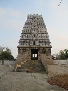
Arakandanallur is a panchayat town in Viluppuram district in the state of Tamil Nadu, India. The place is known for the historic Atulya Nadheswarar Temple built in rock-cut architecture on a small hillock.

Population

Bilariaganj is a town and a nagar panchayat in Azamgarh district in the state of Uttar Pradesh, India.

Chelora is a village in Kannur district in the state of Kerala, India 8 km from Kannur town and on the Kannur-Mysore Highway. The Kannur International Airport is 15 km from Chelora. Kadakkara Sri Dharmasastha Temple and Valannur Sri Risheishwara Temple are the two temples that attract people to the village. Chelora Govt Higher Secondary School is a local educational institution. Kappad, Valannur, Mathukoth, Peringalayi and Konganamkott Para are among the major localities in Chelora.

Ethapur (Yethapur) is a panchayat town in Pethanaickenpalayam Taluk in Salem District in the state of Tamil Nadu, India. Ethapur also referred as "Vasishtronum" named by Vashista one of the Saptarishis.
Kilpennathur is a Panchayat Town in Tiruvanamalai district in the Indian state of Tamil Nadu. Kilpennathur is one of the taluks of Tiruvannamalai district and an assembly constituency of Tamil Nadu. The MLA of Kilpennathur assembly constituency is DMK party Mr. K. Pichandi. Vettavalam is the most populous town panchayat in this taluk. Kilpennathur is located a 12.25 degrees latitude and 79.224 degrees longitude. Nearest towns are Avalurpet, Vettavalam, Gingee and Tiruvannamalai, and Chennai is about 177 km away.

Manapakkam is a census town and part of the Chennai Metro city, in the Indian state of Tamil Nadu. Manapakkam is located along the Mount-Poonamallee Road in Chennai. It is now a home to many IT companies and L&T. Manappakam has beautiful and scenic Adyar River Bank Trail suitable for morning walkers and joggers, it's a 3 Kms stretch extended till Chennai Airport's secondary Runway Bridge.

Modak is a census town in Kota district in the Indian state of Rajasthan. Modak is in Ramganjmandi Tehsil. It is located 61 km south of Kota, the district headquarters.
Neikkarapatti is a panchayat town in Dindigul district in the Indian state of Tamil Nadu.
Pirawa is a city and a municipality in Jhalawar district in the India. The pride of pirawa is "Mr.Nafis ahmed khan" ex minister Rajasthan. Her son "Mr. Masum ahmed khan(baba)" is parshad of ward no.20 nagar palika pirawa and ex youth Rajasthan sachiv..

Puthukkad is a town on the banks of Kurumali River, also known as Mupliyam River, in Kerala. The town is 15 km (9.3 mi) to the south of Thrissur, 16 km (9.9 mi) to the north of Chalakudy, and 1.2 km (0.75 mi) west of Cheruval. The National highway NH 544 passes through thi town.
Rayagiri is a panchayat town in TENKASI district in the Indian state of Tamil Nadu.
Sriramnagar is a census town in Vizianagaram district of the Indian state of Andhra Pradesh. It is located in Garividi mandal of Vizianagaram revenue division.
Thingalnagar is a town panchayat located in Kanniyakumari district in the Indian state of Tamil Nadu.
Varadarajanpet is a panchayat town in Ariyalur district in the Indian state of Tamil Nadu.
Veeravanallur is a selection grade special panchayat town in the Tirunelveli district in the Indian state of Tamil Nadu.

Villiappally is a census town in Kozhikode district in the Indian state of Kerala. Villiappally is the headquarters of Villiappally Panchayath, which contains two villages, Memunda and Villiappally. There is a Vocational Higher Secondary School in this village.
Walajabad is a panchayat town in Kancheepuram district in the Indian state of Tamil Nadu. It is the main town in Walajabad taluk.
Uthukottai is a town in Suburbs of Chennai, one of the taluk headquarters in Thiruvallur District Tamil Nadu, also one of the border towns of Tamilnadu - Andhra Pradesh, located on the banks of the Arani river. This town is the central hub for many nearby towns and villages for their needs of education, markets, shops, businesses, banks, travel, transport and entertainment(Movie Theatres, badminton courts, cricket grounds, Gyms). The town features a channel which helps to direct water from the Krishna river for local irrigation.
