
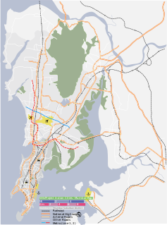
Ooty, officially known as Udagamandalam, is a town and a municipality in the Nilgiris district of the Indian state of Tamil Nadu. It is located 86 km north of Coimbatore and 128 km south of Mysore and is the headquarters of the Nilgiris district. It is a popular hill station located in the Nilgiri Hills. Local residents call it Queen of Hills.

The Nilgiris district is one of the 38 districts in the southern Indian state of Tamil Nadu. Nilgiri is the name given to a range of mountains spread across the borders among the states of Tamil Nadu, Karnataka and Kerala. The Nilgiri Hills are part of a larger mountain chain known as the Western Ghats. Their highest point is the mountain of Doddabetta, height 2,637 m. The district is contained mainly within the Nilgiri Mountains range. The administrative headquarters is located at Ooty. The district is bounded by Coimbatore and Palakkad to the south, Erode to the east, Chamarajnagar district of Karnataka and Wayanad district of Kerala to the north, and Malappuram district of Kerala to the west. As it is located at the junction of three states namely Tamil Nadu, Kerala, and Karnataka, a significant Malayali and Kannadiga population reside in the district.

Ponmudi is a hill station in the Peringamala gramapanchayath of Trivandrum District of Kerala in India. It is located 24 km from Vithura 53 km north-east of Trivandrum City, 78 km south-east of Varkala Beach and 69 km north-east of Kovalam Beach at an altitude of 1,100 m (3,600 ft). Ponmudi (Varayadumotta) peak is a part of the Western Ghats mountain range that runs parallel to the Arabian Sea. Ponmudi is also called Kashmir of Kerala and is a popular honeymoon destination in South India. The normal temperature of Ponmudi is between 18 and 25 °C.

Roha is a small city and taluka in the Raigad district of the Maharashtra state of India. It is located 120 km southeast of Mumbai. It is the starting point of Konkan railways and end point of central railways(Mumbai). Many chemical industries have opened up their manufacturing bases in Roha. Roha is located between the banks of the Kundalika River and the hills of Kalasgiri. It has a population of over 20,849.Roha is connected to Mumbai by Panvel-Roha railway line. Roha is also the northern end of the Konkan Railway. Roha is off of the Mumbai Goa Highway, via the Kolad road.

Anamudi is a mountain located in the Indian state of Kerala. It is the highest peak in the Western Ghats and South India, at an elevation of 2,695 metres (8,842 ft) and a topographic prominence of 2,479 metres (8,133 ft). It lies on the border of Devikulam Taluk, Idukki district and Kothamangalam Taluk, Ernakulam district. The name Anamudi literally translates to "elephant's head" a reference to the resemblance of the mountain to an elephant's head. Anamudi Shola National Park (ASNP) was declared as National Park in December 2003 as per Notification No. 12876/F2 2003/F & WLD dated 14.12.2003 of Government of Kerala.
Panvel is a city Raigad district of Maharashtra in India. It is highly populated due to its closeness to Mumbai. Panvel is also governed for development purpose by the body of Mumbai Metropolitan Region. Panvel is the first Municipal Corporation in Raigad and the 27th Municipal corporation of Maharashtra State.

Sulthan Bathery, formerly known as Sultan's Battery and Ganapathyvattam is a town and municipality in Wayanad district of Kerala, India, near the borders with Tamil Nadu and Karnataka states. It is The second largest city in Wayanad district, it is the headquarters of Sultan Bathery taluk.

The Lawrence School, Lovedale, the namesake of its founder Brigadier-General Sir Henry Montgomery Lawrence KCB, is a co-educational boarding school located at Lovedale, which is a little town on the Nilgiri Mountains in the south Indian state of Tamil Nadu.
Brinchang is a town and hill resort located at an altitude of 1,540 metres (5,050 ft) in Cameron Highlands in the state of Pahang, Malaysia.
Gudalur is a municipality and taluk in Nilgiris district in the Indian state of Tamil Nadu. Gudalur is one of the major towns in West Tamil Nadu and is located at 52 km from Ooty in the hilly terrain of The Nilgiris district. It is situated at the junction of Tamil Nadu, Kerala and Karnataka. Tea plantations dot the whole region, and the regional economy is heavily dependent on the tea industry. The land was an offspring of the exploration done by the British during the pre-independence period to cultivate tea plantations. Being a satellite town between Ooty and Mysore, both tourist spots, Gudalur has the prospect of developing into another tourist destination. Gudalur is a place where one can see people from the three states of Tamil Nadu, Kerala, and Karnataka live together cordially. Malayalam is the most spoken language in Taluk. Apart from that Chetti, Paneya, Nayaka, Kannada language are also spoken by some people.

Hebron School is a co-educational day and boarding independent international Christian school in Ootacamund, the hill station also known as Ooty, in the state of Tamil Nadu, southern India. The school is a boarding school operated by a Protestant Christian trust with the aim of providing education to the children of Christian workers and other families, predominantly those living in India, but also from other parts of Asia.

Arta is a town in southeastern Djibouti. The center of the Arta Region, it is the country's sixth-largest city. As of 2010, the population was 11,043. Arta is situated on the Mountains of Arta and is famous for its mild climate. It is located some 41 kilometres west of the national capital, Djibouti City.

Wellington is a town in The Nilgiris District in the Indian state of Tamil Nadu, three kilometres to the north of Coonoor on the NH181. The town includes a Wellington Bazaar, and the Wellington Cantonment. The Wellington Cantonment is home to The Madras Regimental Centre (MRC) and The Defence Services Staff College (DSSC). The Nilgiri Passenger train passes through Wellington, which also has a railway station.

Badagaon Dhasan is a town and a Nagar Parishad in Tikamgarh district in the state of Madhya Pradesh, India.

Bhowali[bʱəʋaːli] is a town and a municipal board in Nainital District in the state of Uttarakhand, India. It is situated at a distance of 11 km (6.8 mi) from the city of Nainital, the district headquarters; at an average elevation of 1,654 m (5,427 ft) from sea level. It is the seat of Bhowali tehsil, one of the eight subdivisions of Nainital district.

Ketti also called Ketti Valley is a small town nestled in a large valley of the same name. It is located in The Nilgiris District of Tamil Nadu State, South India and is a Revenue Village of Coonoor Taluk. Upper Ketti is another village called Yellanahalli, which is located on the main Coonoor to Ooty road.

Pykara is river 19 kilometres (12 mi) from Ooty in the Indian State of Tamil Nadu with a village by the same name nearby. The Pykara River is considered very sacred by the Todas. It rises at Mukurthi peak, flows northwards, and then turns to the west after reaching the edge of the plateau. The river flows through Murkurti, Pykara and Glenmorgan dams, and forms part of an important hydro-electric power project.
Tamil Nadu has the largest tourism industry in India with an annual growth rate of 16%. In 2015, the number of domestic arrivals was at 333.5 million making the state the most popular tourist destination in the country, and foreign arrivals numbered 4.68 million, the highest in the country, making it the most popular state for tourism in the country.
St. Joseph's Higher Secondary School is a boys' school located in the scenic hill station town Ooty, which is part of The Nilgiris district in Tamil Nadu, India. The school was started by Christian missionaries in 1820.

Mulligoor (முள்ளிகூர்) is a village in the Kundah taluk of Nilgiris District of Tamil Nadu State, India. It is situated 10 kilometers away from sub-district headquarters Kundah and 30 kilometers from district headquarters Ooty. The main cultivation in Mulligoor is tea growing. This area surrounding Mulligoor is also very rich in wildlife.

