Nilambur is a major town, a municipality and a Taluk in the Malappuram district of the Indian state of Kerala. It is located close to the Nilgiris range of the Western Ghats on the banks of the Chaliyar River.[4] This place is also known as 'Teak Town' because of the abundance of Nilambur teaks, which is a variety of a large, deciduous tree that occurs in mixed hardwood forests. Unlike many Municipalities of India; Nilambur is covered with large amounts of vegetation, making it very scenic.
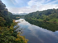
In the British records, Nilambur and its surroundings are collectively described as Nilambur Valley.[5] The bank of river Chaliyar at Nilambur region is also known for natural Gold fields.[6] Explorations done at the valley of the river Chaliyar in Nilambur has shown reserves of the order of 2.5million cubic meters of placers with 0.1 gram per cubic meter of gold.[7] The hilly forested area of Nilambur Taluk forms a portion of the Nilgiri Biosphere Reserve of rich biodiversity. Nilambur is located about 90km (56mi) west of Ooty and 48km (30mi) southwest of Gudalur town, and 27km (17mi) northeast of Manjeri, on Ooty-Gudalur-Nilambur-Calicut road.
The 2,554m (8,379ft) m high Mukurthi peak, which is situated in the border of Nilambur Taluk and Ooty Taluk, and is also the fifth-highest peak in South India as well as the third-highest in Kerala after Anamudi (2,696m[8,845ft]) and Meesapulimala (2,651m[8,698ft]), is the highest point of elevation in Malappuram district. It is also the highest peak in Kerala outside the Idukki district. The 2,383m (7,818ft) high Anginda peak, which is located closer to Malappuram-Palakkad-Nilgiris district border is the second-highest peak. Vavul Mala, a 2,339m[7,674ft] high peak situated on the trijunction of Nilambur Taluk of Malappuram, Wayanad, and Thamarassery Taluk of Kozhikode districts, is the third-highest point of elevation in the district. The Nilambur Taluk has several small and medium-sized tributaries of Chaliyar river.
UNESCO has included Nilambur in its Global Network of Learning Cities (GNLC) in recognition of its outstanding efforts to make lifelong learning a reality for all at the local level.[8]
Etymology
It is believed that Nilambur was derived from Nilambapuri, the old name of Nilambur Kingdom.
The teaks for the construction of Uru, a kind of ships those were used for maritime trade through Beypore port, were usually taken from Nilambur Teak Forests.[9] The oldest teak plantation of the world in the Conolly's plot is just twokm (1.2mi) from the town. It was named in memory of Henry Valentine Conolly, the then Malabar district collector.[10]Teak Museum at Nilambur is maintained by the Kerala Forest Research Institute which was established for the memory of the oldest known Teak plantation in the world. The town is also famous for Nilambur Kovilakam, where the Nilambur Rajas resided and ruled the land.[11]Nilambur Rajas were vassals to the Zamorins of Calicut, based at Nilambur.
The Nilambur–Shoranur line is among the shortest as well as picturesque broad gauge railway lines in India.[12] It was laid by the British in colonial era for the transportation of Nilambur Teak logs into United Kingdom through Kozhikode. During British rule, Nilambur's chief importance laid in producing teaks. In the old administrative records of the Madras Presidency, it is recorded that the most remarkable plantation owned by Government in the erstwhile Madras Presidency was the Teak plantation at Nilambur planted in 1844.[13]
Nilambur Teak is the first forest produce to get its own GI tag.[14]
On 2nd September 2022, Nilambur joined the UNESCO Global Network of Learning Cities (GNLC).[15]
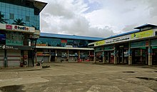
A road in NilamburThe main block of Amal college of Advanced studies in NilamburJawaharlal Nehru Municipal Bus Stand at Nilambur
Nilambur is well connected to other parts of the Kerala and other parts of the country by road and rail networks. Kozhikode-Nilambur-Gudalur (SH 28) road which is a major interstate highway runs through the heart of Nilambur. Other State highways such as SH 39 (Perumbilavu - Nilambur Road) and SH 73 (Valanchery - Nilambur Road) also serves this town. Construction for Hill Highway is ongoing here. There are also wide and good quality direct road towards Kakkadampoyil of Kozhikode district from here. There is a large fleet of government and private buses and other transports serving this town. There is a KSRTC sub depot which serves the area operating both interstate and intrastate Public bus transport. This town is also served by a railway station called Nilambur road which is the terminus of Nilambur–Shoranur railway line. This railway station connects this town to other parts of India as it has regular trains which leads to shoranur junction which is the largest railway station of Kerala state.
The Nilambur–Shoranur line is among the shortest as well as picturesque broad gauge railway lines in India.[12] The railway line is surrounded by teak trees. It was laid by the British in colonial era for the transportation of Nilambur Teak logs into United Kingdom through Kozhikode.
This page is based on this Wikipedia article Text is available under the CC BY-SA 4.0 license; additional terms may apply. Images, videos and audio are available under their respective licenses.