Taliparamba is a Municipality in Taliparamba taluk of Kannur district, Kerala, India. The municipal town spreads over an area of 18.96 square kilometres (7.32 sq mi) and is inhabited by 44,247 number of people.

Payyanur, is a municipal town and a taluk, a sub-district administrative unit, in the Kannur district of Kerala, India. On 10 March 2018, Kerala Chief Minister Pinarayi Vijayan inaugurated Payyanur as the fifth taluk in the district. Payyanur taluk comprises 22 villages including 16 de-linked from the Taliparamba taluk and six from the Kannur taluk. The town is situated on the banks of the Perumba River.
Pariyaram is a Grama Panchayat consisting of two villages viz. Pariyaram census town and Kuttiyeri village. Pariyaram is a suburb of Taliparamba on National Highway between Taliparamba and Payyanur in Kerala state of India. Mini villages of Thiruvattoor, Koran Peedika, Mukkunnu & Chithappile Poyil are parts of Pariyaram.

Ulikkal is a growing town in Kannur District in Kerala. It is the HQ of Ulikkal Grama Panchayat in Iritty Taluk. Kerala State Hill highway SH 59 passes through Ulikkal Town.

Kalliasseri is a census town in Kannur district in the Indian state of Kerala. Kalliaseri Panchayat comprises two villages: Kalliasseri and Irinave.

Sreekandapuram is a municipality in Kannur district, in the Indian state of Kerala.

Punnakkulangara is a significant part as well as a Municipal Ward of Anthoor Municipality in Kannur district of Kerala, India.

Pattuvam is a village in Kannur district in the Indian state of Kerala. It is bordered by the Kuppam river on the north, west and south. It shares a border with Taliparamba municipality on the east. A bridge over the river connects Pattuvam to Kottakkeel of Ezhome village in the northwest.

Kurumathur is a census town in Taliparamba taluk of Kannur district in Kerala state, India. Kurumathur is located 8 km (5.0 mi) east of Taliparamba town in SH 36.
Kuttiattoor is a census town in Taliparamba taluk of Kannur district in the Indian state of Kerala. Kuttiattoor is located 26 km (16 mi) north east of District headquarters Kannur and 6.5 km (4.0 mi) south east of Mayyil.
Nediyanga is a village comes under Sreekandapuram Municipality in Kannur district in the Indian state of Kerala.

Payyavoor is a small town in Kannur district in the Indian state of Kerala. It's the headquarters of Payyavoor Grama Panchayat.
Eruvessi is a village in Irikkur Block Panchayat, Taliparamba Taluk, Kannur district in Kerala, India, around 50 kilometers from Kannur. It was ruled by Mannanar dynasty of Muthedath Aramana and Elayadath Aramana.
Aroli is a village of Pappinisseri Panchayat in Kannur district in the Indian state of Kerala.

Anthoor is a municipality, in Taliparamba taluk of the Kannur district in Kerala, India. The municipality had a population of 28,218 in the 2011 Indian census.

Kannur district is politically organized into a complex web of taluks, blocks, panchayaths and villages. In addition, there are also parliamentary divisions called Assembly constituencies and Lok Sabha constituencies.
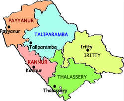
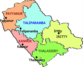
Kannur taluk is an administrative division of Kannur district of Kerala, India. Kannur district is divided into five taluks, Thalassery, Kannur, Payyanur, Iritty and Taliparamba. Thalassery has 35 villages, Kannur has 28, Payyanur has 22, Taliparamba has 28 villages and Iritty has 20 villages.
Anchampeedika is a town in the Kannur district of the North Malabar region in the Indian state of Kerala. Anchampeedika is located roughly 13.5 km from the Kannur Corporation, and it is adjacent to the Taliparamba municipality.
Payyanur taluk comes under Taliparamba revenue division in Kannur district of Kerala, India. Payyanur is one of the 5 taluks in Kannur district established in March 2018 carved out from Taliparamba and Kannur taluks. Payyanur taluk comprises 22 villages including 16 delinked from Taliparamba taluk and 6 from Kannur taluk. It borders Kasaragod district in the north, Taliparamba and Kannur taluk in the south and Karnataka state in the east. Most of the government offices are in Payyanur Mini Civil Station. Payyanur taluk consists of Payyanur Municipality and 11 Panchayats.
Iritty taluk is one of five taluks in Kannur district of Kerala, India. Iritty was established as a taluk in March 2013 when UDF government declared new 12 taluks for the state. Iritty taluk borders with Taliparamba taluk in the north, Thalassery taluk in the west and Karnataka state towards the east. It comprises Iritty municipality, parts of Mattannur municipality and 11 surrounding panchayats.