Pulingome

Last updated

Pulingome
Village
Kottathalachi Mount.JPG
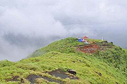
Kottathalachi Mount near Pulingome
India Kerala location map.svg
Red pog.svg
Pulingome
Location in Kerala, India
India location map.svg
Red pog.svg
Pulingome
Pulingome (India)
Coordinates: 12°17′0″N75°25′0″E / 12.28333°N 75.41667°E / 12.28333; 75.41667
CountryFlag of India.svg  India
State Kerala
District Kannur
Area
  Total28.8 km2 (11.1 sq mi)
Population
 (2011)
  Total10,672
  Density370/km2 (960/sq mi)
Languages
  Official Malayalam, English
Time zone UTC+5:30 (IST)
PIN
670511
Telephone code04985
ISO 3166 code IN-KL
Vehicle registration KL-86
Nearest city Payyannur
Lok Sabha constituency Kasaragod
Website http://www.pulingome.com


Pulingome is a village in Kannur District of Kerala state, India. [1]

Contents

Location

Pulingome is a village located in Cherupuzha Grama Panchayat, in the Kannur district in northern Kerala. Located between the Western Ghats and the Karnataka forest, It is 76 km away from Kannur and 37 km from Payyanur.

Demographics

As of 2011 Census, Pulingome village which spreads over an area of 28.8 km2 (11.1 sq mi) had total population of 10,672 which 5,237 males and 5,435 females. Total number of households were 2,631 in the village limits. Population of children in the age group 0-6 was 1,014 (9.5%) where 518 are males and 496 are females. Pulingome village had overall literacy of 94% where male literacy was 95.4% and female literacy was 92.8%. [2]

History

Pulingome was under the rule of Mushika dynasty of Ezhimala during the Sangha Age. Later, this became part of "Kolathunadu" under Chirakkal dynasty. Pulingome had a well established society and a rich culture all through its history. The ancient Sree Sankaranarayan temple here is believed to be set up by "Parasuram". The Pulingome Makham were two holy men of Islam, were buried some 1300 years ago and the remaining of a temple in the Karnataka forest near the border are examples of Pulingome’s cultural heritage. Later with the invasion of Tippu these regions were brought under Mysore kingdom and after Tippu’s death the region was under British rule. The Kamballur Kottayil Nambiar clan were the landlords of the Pulingome village and surrounding areas up until land reform in Kerala in the 1960s. [3]

Transportation

The national highway passes through Perumba junction. Goa and Mumbai can be accessed on the northern side and Cochin and Thiruvananthapuram can be accessed on the southern side. The road to the east of Iritty connects to Mysore and Bangalore. The nearest railway station is Payyanur on Mangalore-Palakkad line. Trains are available to almost all parts of India subject to advance booking over the internet. There are airports at Kannur, Mangalore and Calicut. All of them are international airports but direct flights are available only to Middle Eastern countries.

Related Research Articles

Pariyaram is a Grama Panchayat consisting of two villages viz. Pariyaram census town and Kuttiyeri village. Pariyaram is a suburb of Taliparamba on National Highway between Taliparamba and Payyanur in Kerala state of India. Mini villages of Thiruvattoor, Koran Peedika, Mukkunnu & Chithappile Poyil are parts of Pariyaram.

<span class="mw-page-title-main">Ulikkal</span> Town in Kerala, India

Ulikkal is a growing town in Kannur District in Kerala. It is the HQ of Ulikkal Grama Panchayat in Iritty Taluk. Kerala State Hill highway SH 59 passes through Ulikkal Town.

<span class="mw-page-title-main">Cheruthazham</span> Census Town in Kerala, India

Cheruthazham is a Census Town and Grama Panchayat in Kannur district in the state of Kerala, India. It is the location of the famous Hanumarambalam, dedicated to Sri Rama and Hanuman.Cherutazham is also the birthplace of Kalamandalam Krishnan Nair who gave a new dimension to the art of Kathakali. There are many artists in Cherutazham who are experts in the traditional musical items like "panchavadyam", "taayambaka", "chenda melam" etc. The new generation of Cherutazham is also getting trained in these art forms.

Iriveri is a census town in Kannur district in the Indian state of Kerala.

Mavilayi is a census town in Kannur district in the Indian state of Kerala. Situated in Peralasseri Panchayath on Kannur-Kuthuparamba State Highway, 15 km away from Kannur Town.

<span class="mw-page-title-main">Naduvil and Kudianmala</span> Town in Kerala, India

Naduvil is a small town in Kannur district in the Indian State of Kerala. The town is the headquarters of Naduvil Grama panchayat.

<span class="mw-page-title-main">Cherupuzha, Kannur</span> Town in Kerala, India

Cherupuzha is a town in Kannur district, Kerala, India. It is the headquarters of the Cherupuzha Panchayat which is a special grade panchayat in Kerala.

Ayyankunnu is a village in Kannur district in the Indian state of Kerala.The name ayyankunnu came from the five hills "Anchu Kunnu".

Chuzhali is a village in the Kannur district of the Indian state of Kerala.

Eramam is a village in Kannur district in Indian state of Kerala.

<span class="mw-page-title-main">Ezhome</span> Census Town in Kerala, India

Ezhome is a census town in Kannur district in the Indian state of Kerala.

<span class="mw-page-title-main">Kannavam</span> Village in Kerala, India

Kannavam is a Village in Thalassery Taluk in Kannur District of Kerala State, India. It comes under Chittaripparamba Panchayat. It is located 37 km (23 mi) south east of District headquarters Kannur, 13 km (8.1 mi) east of Kuthuparamba and 466 km (290 mi) from State capital Thiruvananthapuram

<span class="mw-page-title-main">Karivellur</span> Census town in Kerala, India

Karivellur is a census town and Gram Panchayat in Kannur district of Kerala state, India.

Panapuzha is a village in Kannur district in the Indian state of Kerala.

Perinthatta is a village in Kannur district in the Indian state of Kerala.

Thimiri is a village in Kannur district in the Indian state of Kerala. An ancient Shiva temple called Thimiri Sree Shiva Kshethra is situated here.

<span class="mw-page-title-main">Thirumeni</span> Village in Kerala, India

Thirumeni is a village in Kannur district in the Kerala state of India. It is known for its hill station Chathamangalam Hills. The village has several recently migrated families from various parts of the erstwhile political entity (state) of Travancore who settled here in the famed "Malabar migration period" in the nineteenth century. Most of the inhabitants of the village reside in the valley of three major hills by name Chathamangalam Theruvamala alias Alumbumala, Kottathalachimala and Thevarkunnumala. Thirumeni is a small junction with a few government institutions, religious institutions and small shops in int. and is subdivided into smaller villages like Kokkadave, Prapoyil, Chathamangalam (Kannur), Thabore, Muthuvom, Korali, Chattivayal, Thannichal, Paruthikallu etc.

Vayakkara is a village located in Payyanur Taluk of Kannur district in the Indian state of Kerala.

Vellora is a village in Kannur district in the Indian state of Kerala. It has state road connectivity, schools, hospitals, post office, and bank dating back to the 1950s.

Eruvessi is a village in Irikkur Block Panchayat, Taliparamba Taluk, Kannur district in Kerala, India, around 50 kilometers from Kannur. It was ruled by Mannanar dynasty of Muthedath Aramana and Elayadath Aramana.

References

  1. "Census of India : Villages with population 5000 & above". Registrar General & Census Commissioner, India. Archived from the original on 8 December 2008. Retrieved 10 December 2008.
  2. Kerala, Directorate of Census Operations. District Census Handbook, Kannur (PDF). Thiruvananthapuram: Directorateof Census Operations,Kerala. p. 154,155. Retrieved 14 July 2020.
  3. "Religious amity to the fore at Uroos". The Hindu . Retrieved 22 January 2018.