Pariyaram

Last updated

Pariyaram
India Kerala location map.svg
Red pog.svg
Pariyaram
Location in Kerala, India
India location map.svg
Red pog.svg
Pariyaram
Pariyaram (India)
Coordinates: 12°04′24″N75°17′30″E / 12.0732°N 75.2917°E / 12.0732; 75.2917 Coordinates: 12°04′24″N75°17′30″E / 12.0732°N 75.2917°E / 12.0732; 75.2917
CountryFlag of India.svg  India
State Kerala
District Kannur
Taluk Taliparamba
Government
  Type Panchayati raj (India)
  BodyPariyaram Grama Panchayat
Area
  Total32.68 km2 (12.62 sq mi)
Population
 (2011)
  Total20,405
  Density620/km2 (1,600/sq mi)
Languages
  Official Malayalam, English
Time zone UTC+5:30 (IST)
PIN
670502, 670503
ISO 3166 code IN-KL
Vehicle registration KL-59
Literacy 93.19
Lok Sabha constituency Kannur
Assembly constituency Taliparamba

Pariyaram is a Grama Panchayat consisting of two villages viz. Pariyaram census town and Kuttiyeri village. Pariyaram is a suburb of Taliparamba on National Highway (NH 66) between Taliparamba and Payyanur in Kerala state of India. [1] [2] Mini villages of Thiruvattoor, Koran Peedika, Mukkunnu & Chithappile Poyil are parts of Pariyaram.

Contents

Even though the Government Medical College, Kannur was formerly known as Pariyaram Medical College, the same is located in Kadannappally- Panapuzha Grama panchayat.

Educational Institutions

Demographics

As of 2011 census, Pariyaram census town had total population of 20,405 where 9,582 males and 10,823 females with an area spreads over 32.68 km2 (12.62 sq mi). Total number of households were 4,580 in the town limits. Population of children in age group 0-6 was 2,519 (12.3%) which constitutes 1,249 males and 1,270 females. Pariyaram town had overall literacy of 93.2% where male literacy was 96.8% and female literacy was 90%. [4]

Religions

As of 2011 Indian census, Pariyaram census town had total population of 20,405 which constitute 9,329 (45.7%) Hindus, 7,818 (38.3%) Muslims, 3,194 (15.7%) Christians and Others (0.3%). [5]

Administration

Pariyaram Panchayat is part of Taliparamba Assembly constituency under Kannur Loksabha constituency. [6]

Law and Order

Pariyaram Medical College Police Station was established on 10th February 2009 adjacent to the Pariyaram Government Medical College situated in Kadannapalli village. The old station building was renovated and inaugurated on 06.03.2022 by Hon’ble Chief Minister of Kerala, Pinarayi Vijayan. The police station is part of Kannur rural police district and has jurisdiction over Kadannappalli, Panapuzha, Cheruthazham and Pariyaram villages with an area of 118.01 Sq kms. [7] [8]

Transportation

The national highway passes through Pariyaram. Mangalore and Mumbai can be accessed on the northern side and Cochin and Thiruvananthapuram can be accessed on the southern side. The road from Taliparamba to the east of Iritty connects to Mysore and Bangalore. It will take approximately 45 minutes by Bus to reach Pariyaram from the district headquarters Kannur. The nearest railway stations are Payangadi and Payyannur on Mangalore-Palakkad line. There are airports at Kannur, Mangalore and Calicut. All of them are international airports but direct flights are available only to Middle Eastern countries.

See also

Related Research Articles

<span class="mw-page-title-main">Taliparamba</span> Municipality in Kerala, India

Taliparamba is a Municipality in Taliparamba taluk of Kannur district, Kerala, India. The municipal town spreads over an area of 18.96 square kilometres (7.32 sq mi) and is inhabited by 44,247 number of people.

<span class="mw-page-title-main">Payyanur</span> Municipality in Kerala, India

Payyanur, IPA: [pɐjːɐn̺ːuːɾ], is a municipal town and a taluk, a sub-district administrative unit, in the Kannur district of Kerala, India. On 10 March 2018, Kerala Chief Minister Pinarayi Vijayan inaugurated Payyanur as the fifth taluk in the district. Payyanur taluk comprises 22 villages including 16 de-linked from the Taliparamba taluk and six from the Kannur taluk. The town is situated on the banks of the Perumba River.

Padiyoor is a small town in Kannur district of Kerala state, India. Padiyoor village is part of Padiyoor-Kalliad Grama Panchayat in Iritty taluk.

<span class="mw-page-title-main">Vellavu</span> Village in Kerala, India

Vellavu is a place in the Pariyaram gram panchayat of the Kannur District, state of Kerala, India.

<span class="mw-page-title-main">Irikkur</span> Census Town in Kerala, India

Irikkur is a town and grama panchayat in Kannur District of Kerala state, India.

<span class="mw-page-title-main">Peravoor</span> Town in Kerala, India

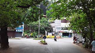
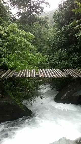
Peravoor is a small town and Grama Panchayat in Kannur district of Kerala state in India. It is located 50 km (31 mi) east of Kannur and 40 km (25 mi) north east of Thalassery. And Iritty, the nearest municipality is 14 km (8.7 mi) north of Peravoor. Peravoor is situated in the Western Ghats mountain range.

<span class="mw-page-title-main">Ulikkal</span> Town in Kerala, India

Ulikkal is a growing town in Kannur District in Kerala. It is the HQ of Ulikkal Grama Panchayat in Iritty Taluk. Kerala State Hill highway SH 59 passes through Ulikkal Town.

<span class="mw-page-title-main">Mayyil</span> Census Town in Kerala, India

Mayyil is a Census Town and Grama Panchayat in Kannur District of Kerala State. Mayyil Panchayat established in 1962 by merging the villages of Kayaralam, Mayyil and Kandakkai.

<span class="mw-page-title-main">Sreekandapuram</span> Municipality in Kerala, India

Sreekandapuram is a municipality in Kannur district, in the Indian state of Kerala.

Koodali is a census town and grama panchayat in Thalassery taluk of Kannur district in Kerala state, India. Koodali is located 15.5 km (9.6 mi) east of Kannur city on Kannur-Mattanur road.

<span class="mw-page-title-main">Naduvil and Kudianmala</span> Town in Kerala, India

Naduvil is a small town in Kannur district in the Indian State of Kerala. The town is the headquarters of Naduvil Grama panchayat.

<span class="mw-page-title-main">Alakode, Kannur district</span> Town in Kerala, India

Alakode is an emerging town in Kannur district in the Indian state of Kerala. It is located 46 km (29 mi) North of District headquarters Kannur. Alakode is located on Taliparamba-Manakadavu-Coorg Road. Alakode was one of the major centers of Malabar Migration.

<span class="mw-page-title-main">Ezhome</span> Census Town in Kerala, India

Ezhome is a census town in Kannur district in the Indian state of Kerala.

<span class="mw-page-title-main">Kanichar</span> Village in Kerala, India

Kanichar is a village and Grama Panchayat in Kannur district in the Indian state of Kerala.

<span class="mw-page-title-main">Kurumathur</span> Census Town in Kerala, India

Kurumathur is a census town in Taliparamba taluk of Kannur district in Kerala state, India. Kurumathur is located 8 km (5.0 mi) east of Taliparamba town in SH 36.

Kuttiattoor is a census town in Taliparamba taluk of Kannur district in the Indian state of Kerala. Kuttiattoor is located 26 km (16 mi) north east of District headquarters Kannur and 6.5 km (4.0 mi) south east of Mayyil.

<span class="mw-page-title-main">Kuttiyeri</span> Village in Kerala, India

Kuttiyeri is a village of Pariyaram Grama Panchayath near Taliparamba town in Kannur district in the Indian state of Kerala. Mini villages of Vellavu, Mavichery, Thalora & Panangattoor are parts of Kuttiyeri.

<span class="mw-page-title-main">Payyavoor</span> Town in Kerala, India

Payyavoor is a small town in Kannur district in the Indian state of Kerala. It's the headquarters of Payyavoor Grama Panchayat.

<span class="mw-page-title-main">Chapparapadavu</span> Village in Kerala, India

Chapparapadavu is a Grama panchayat in Kannur district in the Indian state of Kerala. Chapparapadavu Panchayat have administration over the villages of Kooveri, Thimiri and Vellad.

Kolachery is a census town and Grama Panchayat in Kannur District of Kerala state, India. Kolachery is located 15 kilometres (9.3 mi) north east of Kannur city.

References

  1. "Kerala (India): Districts, Cities and Towns - Population Statistics, Charts and Map".
  2. "Population data - Villages with population 5000 & above". www.censusindia.gov.in. Archived from the original on 8 December 2008. Retrieved 12 January 2022.
  3. "Educational Institutes in Kannur-Kerala". vidyatime.com.
  4. Kerala, Directorate of Census Operations. District Census Handbook, Kannur (PDF). Thiruvananthapuram: Directorateof Census Operations,Kerala. p. 180,181. Retrieved 14 July 2020.
  5. "Religion – Kerala, Districts and Sub-districts". Census of India 2011. Office of the Registrar General.
  6. "Assembly Constituencies - Corresponding Districts and Parliamentary Constituencies" (PDF). Kerala. Election Commission of India. Archived from the original (PDF) on 4 March 2009. Retrieved 18 October 2008.
  7. "Pariyaram Mcps Police Station". keralapolice.gov.in.
  8. "4 more police stations in state get new buildings". Times of India . Retrieved 25 September 2022.