Iritty taluk | |
|---|---|
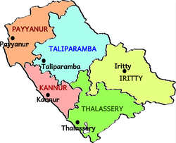 Taluks of Kannur | |
 Iritty taluk Location in Kerala, India  Iritty taluk Iritty taluk (India) | |
| Coordinates: 11°58′55″N75°40′13″E / 11.9819°N 75.6703°E | |
| Country | |
| State | Kerala |
| District | Kannur |
| Established | March 2013 |
| Government | |
| • Type | Taluk |
| Area | |
• Total | 836.08 km2 (322.81 sq mi) |
| Population | |
• Total | 342,118 |
| • Density | 409.19/km2 (1,059.8/sq mi) |
| Languages | |
| • Official | Malayalam, English |
| Time zone | UTC+5:30 (IST) |
| PIN | 670xxx |
| Telephone code | 0498,0490 |
| Vehicle registration | KL 78 |
| Lok Sabha constituency | Kannur |
| Vidhan Sabha constituency | Peravoor, Irikkur, Mattanur |
Iritty taluk is one of five taluks in Kannur district of Kerala, India. [1] Iritty was established as a taluk in March 2013 when UDF government declared new 12 taluks for the state. [2] [3] Iritty taluk borders with Taliparamba taluk in the north, Thalassery taluk in the west, Wayanad district in south and Karnataka state in east. It comprises Iritty municipality, Mattannur municipality and 11 surrounding panchayats.