Chuzhali

Last updated

Chuzhali
Village
India Kerala location map.svg
Red pog.svg
Chuzhali
Location in Kerala, India
India location map.svg
Red pog.svg
Chuzhali
Chuzhali (India)
Coordinates: 12°05′30″N75°26′29″E / 12.0916400°N 75.441400°E / 12.0916400; 75.441400 Coordinates: 12°05′30″N75°26′29″E / 12.0916400°N 75.441400°E / 12.0916400; 75.441400
CountryFlag of India.svg  India
State Kerala
District Kannur
Area
  Total46.19 km2 (17.83 sq mi)
Population
 (2011)
  Total14,759
  Density320/km2 (830/sq mi)
Languages
  Official Malayalam, English
Time zone UTC+5:30 (IST)
PIN
670142
ISO 3166 code IN-KL
Vehicle registration KL-59
Nearest cityTaliparamba
Vidhan Sabha constituencyIrikkur

Chuzhali is a village in the Kannur district of the Indian state of Kerala. [1]

Contents

History

The village is named after the goddess Chuzhali, as it is the abode of Chuzhali (Durga). The village was under the dynasty of Chuzhali Nambiars. In ancient times it was under Chuzhali Swaroopam and the boundary was Koorgu in Karnataka.[ citation needed ]

In Malabar manual, William Logan mentioned Chuzhali as an ideal place for guerilla war, since the main land of Chuzhali is surrounded by high altitude areas, namely Kulathur, Thalakkulam, Edakkulm and Kuunam. Chuzhali Nambiar was one of the commanders of Pazhashiraja's guerilla army. It is said[ by whom? ] that Pazhashiraja visited Chuzhali during his struggle against the British army. Chuzhali Nambiar was caught by the British army and hanged at Thalassery.

Temples

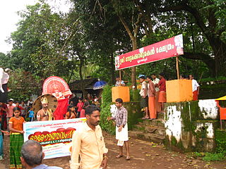
Chuzhali Bhagavathy temple Chuzhali bhagavathy.jpg
Chuzhali Bhagavathy temple

Chuzhali Bhagavathi is a famous temple situated in the middle of the village. The annual festival of this temple takes place during March–April. It is treated by the people of Chuzhali as their village festival. The main attraction near the village is Kulathur, 3 km from the main town of Chalilvayal.

Another famous temple in Chuzhali is Thiruvambadi, dedicated to Lord Sreekrishna. Other temples are Muchilottu Bhagavathi, Aranoor Sastha Bhagavathi, Sree Muthappan Madapura Chuzhali, Kathivanoor Veeran Kshektram Vadakkemoola and Puthiya Bhagavathi Kshethram Mamalathkari.

Demographics

As of 2011 Census, Chuzhali had a population of 14,759 which constitutes 7,147 (48.4%) males and 7,612 (51.6%) females. Chuzhali village has an area of 46.19 km2 (17.83 sq mi) with 3,449 families residing in it. The male female sex ratio was 1,065 lower than state average of 1,084. In Chuzhali, 11.2% of the population was under 6 years of age. Chuzhali had overall literacy of 93.77%, higher than the national average of 75% and lower than the state average of 94.00%. [2]

Transportation

The national highway passes through Taliparamba town. Goa and Mumbai can be accessed to the north and Cochin and Thiruvananthapuram to the south. Taliparamba has a bus station and buses are available to all parts of Kannur district. The road to the east of Iritty connects to Mysore and Bangalore. Buses to these cities are available only from Kannur, 22 km to the south. The nearest railway stations are Kannapuram and Kannur on the Mangalore-Palakkad line.

Trains are available to almost all parts of India. There are airports at Kannur, Mangalore and Calicut. All are small international airports with direct flights available only to Middle Eastern countries.

Related Research Articles

Taliparamba Municipality in Kerala, India

Taliparamba is a Municipality in Taliparamba taluk of Kannur district, Kerala, India. The municipal town spreads over an area of 18.96 square kilometres (7.32 sq mi) and is inhabited by 44,247 number of people.

Vellavu Village in Kerala, India

Vellavu is a place in the Pariyaram gram panchayat of the Kannur District, state of Kerala, India.
Irikkur Census Town in Kerala, India

Irikkur is a census town and grama panchayat in Kannur District of Kerala state, India.

Pariyaram is a Grama Panchayat consisting of two villages viz. Pariyaram census town and Kuttiyeri village. Pariyaram is a small town on National Highway between Taliparamba and Payyanur in Kerala state of India. Mini villages of Thiruvattoor, Koran Peedika, Mukkunnu & Chithappile Poyil are parts of Pariyaram.

Matool Village in Kerala, India

Mattool is a village in Kannur district of Kerala State, India. Mattool is located 19 kilometres (12 mi) north of Kannur city. The Valapattanam River and Kuppam River meet the Arabian sea at Mattool. Mattool can be reached from Kannur via Azheekal crossing the Mattool - Azheekal ferry. And via Madakkara-Matool Bridge From Irinavu Road.

Kalliasseri Census Town in Kerala, India

Kalliasseri is a census town in Kannur district in the Indian state of Kerala. Kalliaseri Panchayat comprises two villages: Kalliasseri and Irinave.

Kannapurampronunciation  is a census town in Kannur district of North Malabar region in the Indian state of Kerala.

Mayyil Census Town in Kerala, India

Mayyil is a Census Town and Grama Panchayat in Kannur District of Kerala State. Mayyil Panchayat established in 1962 by merging the villages of Kayaralam, Mayyil and Kandakkai.

Koodali is a census town in Thalassery taluk of Kannur district in Kerala state, India. Koodali is located 15.5 km (9.6 mi) east of Kannur city on Kannur-Mattanur road.

Cherupuzha (Kannur) Town in Kerala, India

Cherupuzha is a town in Kannur district, Kerala, India. It is the headquarters of the Cherupuzha Panchayat which is a special grade panchayat in Kerala.

Pattuvam Village in Kerala, India

Pattuvam is a village in Kannur district, Kerala, India. It is bounded by Kuppam river on the north-west-south directions. It shares border with Taliparamba municipality on the east. A joint-less bridge over Kuppam river which connects Pattuvam to Kottakkeel of Ezhome village in northwest direction was inaugurate by Chief Minister of Kerala Pinarayi Vijayan in January 2017.

Kuttiyeri Village in Kerala, India

Kuttiyeri is a village of Pariyaram Grama Panchayath near Taliparamba town in Kannur district in the Indian state of Kerala. Mini villages of Vellavu, Mavichery, Thalora & Panangattoor are parts of Kuttiyeri.

Panniyoor is a village in Kannur district in the Indian state of Kerala.

Thimiri is a village in Kannur district in the Indian state of Kerala. An ancient Shiva temple called Thimiri Sree Shiva Kshethra is situated here.

Vellad is a large village in Kannur district in the Indian state of Kerala.

Mavichery is a village which is the part of Pariyaram Gramapanchayath in the Kannur district of Kerala, India.

Aroli Village in Kerala, India

Aroli is a village of Pappinisseri Panchayat in Kannur district in the Indian state of Kerala.

Koonam is a census village in Taliparamba Taluk in North Kerala Division, Kannur District of Kerala, India. It comes under Kurumathoor and chengalayi Panchayaths. It is located about 9 km (5.6 mi) from Taliparamba and 30 km (19 mi) north of Kannur.

Chapparapadavu

Chapparapadavu is a Grama panchayat in Kannur district in the Indian state of Kerala. Chapparapadavu Panchayat have administration over the villages of Kooveri, Thimiri, and Vellad.


Anchampeedika is a town in the Kannur district of the North Malabar region in the Indian state of Kerala. Anchampeedika is located roughly 13.5 km from the Kannur Corporation, and it is adjacent to the Taliparamba municipality.

References

  1. "Census of India : Villages with population 5000 & above". Registrar General & Census Commissioner, India. Archived from the original on 8 December 2008. Retrieved 10 December 2008.
  2. Kerala, Directorate of Census Operations. District Census Handbook, Kannur (PDF). Thiruvananthapuram: Directorate of Census Operations, Kerala. p. 154,155. Retrieved 14 July 2020.