Thirumeni

Last updated

Thirumeni
village
India Kerala location map.svg
Red pog.svg
Thirumeni
Location in Kerala
India location map.svg
Red pog.svg
Thirumeni
Location in India
Coordinates: 12°15′N75°25′E / 12.250°N 75.417°E / 12.250; 75.417 Coordinates: 12°15′N75°25′E / 12.250°N 75.417°E / 12.250; 75.417
CountryFlag of India.svg  India
State Kerala
District Kannur
Government
  BodyCherupuzha Panchayat
Area
  Total23.58 km2 (9.10 sq mi)
Population
 (2011)
  Total8,611
  Density370/km2 (950/sq mi)
Languages
  Official Malayalam, English
Time zone UTC+5:30 (IST)
PIN
670511
Telephone code91-4985
ISO 3166 code IN-KL
Nearest city Payyanur and Taliparamba
Lok Sabha constituency Kasaragod
Vidhan Sabha constituency Payyanur
Chathamangalam Theruvamala Chathamangalam Theruvamala.jpg
Chathamangalam Theruvamala

Thirumeni is a village in Kannur district in the Kerala state of India. It is known for its hill station Chathamangalam Hills. The village has several recently migrated families from various parts of the erstwhile political entity (state) of Travancore (mainly from Pathanamthitta Kottayam and Idukki Districts) who settled here in the famed "Malabar migration period" in the nineteenth century. Most of the inhabitants of the village reside in the valley of three major hills by name Chathamangalam Theruvamala alias Alumbumala, Kottathalachimala and Thevarkunnumala. Thirumeni is a small junction with a few government institutions, religious institutions and small shops in int. and is subdivided into smaller villages like Kokkadave, Prapoyil, Chathamangalam (Kannur), Thabore, Muthuvom, Korali, Chattivayal, Thannichal, Paruthikallu etc. [1]

Contents

Chathamangalam Hills

Chathamangalam (Kannur) is a magnificent hill-station and tourist hangout in the area. Chathamangalam hills is part of Thirumeni village and is just 3.6 km away from Thirumeni town. Chathamangalam hills can be accessible from Kannur or Payyanur or Kanhangad following the route mentioned below.

1)Kannur-Taliparamba-Alakode-Manjakkadu-Thirumeni-Chathamangalam hills

2)Payyannur-Cherupuzha-Thirumeni-Chathamangalam Hills

3)Kanhangad-Cheemeni-Cherupuzha-Thirumeni-Chathamangalam Hills

Demographics

As of 2011 census, Thirumeni village which spreads over 23.58 km2 (9.10 sq mi) area had population of 8,616 where 4,275 are males and 4,336 are females with 2,077 families residing in the village. Population of children in the age group of 0–6 was 793 (9.2%) which consists of 428 males and 365 females. Thirumeni had overall literacy of 96.2% where male literacy stands at 97.5% and female literacy was 95%. [2]

Politics

Thirumeni is a place where Hindus and Christians mainly and a few Muslims live in harmony. The place is surrounded by mountains. Many of the families recently migrated from Pathanamthitta, Kottayam and Idukki districts. The main political parties are Communist Party of India (Marxist), INC, Kerala Congress. The nearest educational institutions are Government Higher Secondary School Thirumeni, SNDPLP School.

Transportation

The national highway passes through Perumba junction. Goa and Mumbai can be accessed on the northern side and Cochin and Thiruvananthapuram can be accessed on the southern side. The road to the east of Iritty connects to Mysore and Bangalore. The nearest railway station is Payyanur on Mangalore-Palakkad line. Trains are available to almost all parts of India subject to advance booking over the internet. There are airports at Kannur, Mangalore and Calicut. All of them are international airports but direct flights are available only to Middle Eastern countries.

Related Research Articles

<span class="mw-page-title-main">Payyanur</span> Municipality in Kerala, India

Payyanur, IPA: [pɐjːɐn̺ːuːɾ], is a municipal town and a taluk, a sub-district administrative unit, in the Kannur district of Kerala, India. On 10 March 2018, Kerala Chief Minister Pinarayi Vijayan inaugurated Payyanur as the fifth taluk in the district. Payyanur taluk comprises 22 villages including 16 de-linked from the Taliparamba taluk and six from the Kannur taluk. The town is situated on the banks of the Perumba River.

Pariyaram is a Grama Panchayat consisting of two villages viz. Pariyaram census town and Kuttiyeri village. Pariyaram is a small town on National Highway between Taliparamba and Payyanur in Kerala state of India. Mini villages of Thiruvattoor, Koran Peedika, Mukkunnu & Chithappile Poyil are parts of Pariyaram.

<span class="mw-page-title-main">Cheruthazham</span> Census Town in Kerala, India

Cheruthazham is a Census Town and Grama Panchayat in Kannur district in the state of Kerala, India. It is the location of the famous Hanumarambalam, dedicated to Sri Rama and Hanuman. Cheruthazham is also the birthplace of Kalamandalam Krishnan Nair who gave a new dimension to the art of Kathakali. There are many artists in Cherutazham who are experts in the traditional musical items like "panchavadyam", "taayambaka", "chenda melam" etc. The new generation of Cherutazham is also getting trained in these art forms.

Kottayam-Malabar is a census town near Kuthuparamba in Kannur district of Kerala state in India. It is different from the city of Kottayam in Kottayam district of the same state.

<span class="mw-page-title-main">Pulingome</span> Village in Kerala, India


Pulingome is a village in Kannur District of Kerala state, India.

<span class="mw-page-title-main">Cherupuzha, Kannur</span> Town in Kerala, India

Cherupuzha is a town in Kannur district, Kerala, India. It is the headquarters of the Cherupuzha Panchayat which is a special grade panchayat in Kerala.

<span class="mw-page-title-main">Alakode, Kannur district</span> Town in Kerala, India

Alakode is an emerging town in Kannur district in the Indian state of Kerala. It is located 46 km (29 mi) North of District headquarters Kannur. Alakode is located on Taliparamba-Manakadavu-Coorg Road. Alakode was one of the major centers of Malabar Migration.

Eramam is a village in Kannur district in Indian state of Kerala.

<span class="mw-page-title-main">Kannavam</span> Village in Kerala, India

Kannavam is a Village in Thalassery Taluk in Kannur District of Kerala State, India. It comes under Chittaripparamba Panchayat. It is located 37 km (23 mi) south east of District headquarters Kannur, 13 km (8.1 mi) east of Kuthuparamba and 466 km (290 mi) from State capital Thiruvananthapuram

<span class="mw-page-title-main">Karivellur</span> Census town in Kerala, India

Karivellur is a census town and Gram Panchayat in Kannur district of Kerala state, India.

Perinthatta is a village in Kannur district in the Indian state of Kerala.

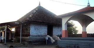
Thimiri is a village in Kannur district in the Indian state of Kerala. An ancient Shiva temple called Thimiri Sree Shiva Kshethra is situated here.

Vayakkara is a village located in Payyanur Taluk of Kannur district in the Indian state of Kerala.

Vellora is a village in Kannur district in the Indian state of Kerala. It has state road connectivity, schools, hospitals, post office, and bank dating back to the 1950s.

Maloth (also known as malom) is a village in Kasaragod district of the state of Kerala., Maloth is a village in Western Ghats. It is situated in the Balal Panchayath of Kasaragod District of Kerala. It is a part of the Kasaragod Parliament constituency. Earlier it was in the Hosdurg assembly constituency which is renamed as Kanhangad after the delimitation of assembly constituencies in 2011. It shares borders with the Karnataka forest. Nearest towns are Kanhangad, Cherupuzha, and Nileshwaram. One can reach Maloth through bus from Kanhangad or from Cherupuzha. Private as well as KSRTC buses playing between Kanhangad and Konnakkad passes through the village.

<span class="mw-page-title-main">Udayagiri, Kerala</span> Village in Kerala, India

Udayagiri is a village in Taliparamba taluk of Kannur District in Kerala, India. It is about 55 km from Kannur city.

<span class="mw-page-title-main">Vellarikundu</span> Town in Kerala, India

Vellarikundu is a town and taluk headquarters in the Hill range of Kasaragod District in the state of Kerala. Vellarikundu is located between Odayanchal and Chittarikkal on Odayanchal-Cherupuzha Road.

<span class="mw-page-title-main">Thabore</span> Village in Kerala, India

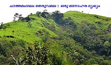
Thabore is a hill top village in Kannur district in the Indian state of Kerala. Some parts of Thabore comes under Udayagiri, Kerala gram panchayat and the rest under Cherupuzha (Kannur) gram panchayat. Tourists come here to see the scenery of the hill station. A statue of Jesus Christ has been recently? installed on the hilltop which attracts a large number of tourists. Nearby places include Udayagiri, Thirumeni, Chathamangalam Hills and Kozhichal.

Kuttur is a village in Payyanur Taluk of Kannur district in the Indian state of Kerala.

Kolthur is a village in Kasaragod taluk of Kasaragod district in Indian state of Kerala.

References

  1. "Census of India : Villages with population 5000 & above". Registrar General & Census Commissioner, India. Retrieved 10 December 2008.Geographically, the village is situated in the Western Ghats and is very close to the Coorg district of Karnataka state.
  2. Kerala, Directorate of Census Operations. District Census Handbook, Kannur (PDF). Thiruvananthapuram: Directorateof Census Operations,Kerala. p. 154,155. Retrieved 14 July 2020.